
Hilgenbach
| Hilgenbach | ||
 Middle part of the Hilgenbach between Steinberg and Düsenberg. (March 25, 2010) |
||
| Data | ||
| Water code | DE : 45262 | |
| location | Bad Driburg , Höxter district , North Rhine-Westphalia , Germany | |
| River system | Weser | |
| Drain over | Hilgenbach → Aa → Nethe → Weser → North Sea | |
| source | On the eastern slope of the Egge Mountains near Bad Driburg at the foot of the Füllenberg 51 ° 43 ′ 26 ″ N , 8 ° 59 ′ 48 ″ E |
|
| Source height | approx. 325 m above sea level NN | |
| muzzle | Between Bad Driburg and Herste in the Aa (Nethe) coordinates: 51 ° 43 '25 " N , 9 ° 3' 41" E 51 ° 43 '25 " N , 9 ° 3' 41" E |
|
| Mouth height | approx. 172 m above sea level NN | |
| Height difference | approx. 153 m | |
| Bottom slope | approx. 28 ‰ | |
| length | approx. 5.5 km | |
| Catchment area | 17.22 km² | |
| Left tributaries | Katzohlbach | |
| Small towns | Bad Driburg | |
 The highest spring in the northern arm of the spring that constantly carries water. (July 21, 2011) |
||
 Hilgenbach estuary, look upstream. In the picture, the Hilgenbach flows into the Aa from the left. A scour forms at the confluence. (July 23, 2011) |
||
The Hilgenbach is an approx. 5.5 km long right tributary of the Aa (Nethe) in the district of Höxter , North Rhine-Westphalia , Germany . It thus belongs to the Weser river system . The western watershed is also the watershed of the Rhine river system . In terms of nature, its valley belongs to the Oberwälder Land and lies in the Teutoburg Forest / Eggegebirge nature park .
The Hilgenbach essentially drains the central and southern part of the Bad Driburg basin , while the northern part is drained by the Schwallenbach . The federal road 64 , which crosses it three times, and the Altenbeken – Kreiensen railway line , which runs parallel to the north in the lower reaches, run through the valley of the Hilgenbach .
geography
course
The Hilgenbach rises on the eastern slope of the Egge Mountains at the foot of the Füllenberg in the Iburg-Aschenhütte nature reserve . Some of the source streams show a significant sintering and thus contribute significantly to the character of this nature reserve.
The stream crosses the southern part of the Bad Driburg basin, with the B 64 flowing under it once in a northern and once in a southern direction. In its course north of the B 64, the Hilgenbach flows through the settlement area of Bad Driburg on the southern edge. South of the B 64 is the former Uhlenmühle on the right, now a private property. In its course south of the B 64, the Hilgenbach then follows the foot of the Sülburg.
The Hilgenbach leaves the Bad Driburg basin in a south-easterly direction between Steinberg in the north and the Düsenberg in the south. In the north follows the Sollberg, in the south the Kohlberg. At this point the former Josefsmühle, today a restaurant for excursions, is on the right. Finally, to the south, the Dohnhauser Feld opens up. From the north comes the valley of the Aa, into which the Hilgenbach flows from the right.
Spring arms
The Hilgenbach rises in 3 steep dry valleys at the foot of the Füllenberg in several sources. Only the lower areas of these valleys constantly carry water below about 325 m above sea level. NN. The southern valley is the widest and most closely corresponds to the course of the stream in a straight line. The arm from the relatively small middle valley is called Hilgenbach on the map in front of the Bad Driburg tourist office. In water information systems available online, the arm from the northern valley is identified as Hilgenbach. This is followed by the geographic coordinate of the source of the info box.

Tributaries
The strongest right-hand tributary flows directly above the Uhlenmühle (water code number: 452622), which carries as much water as the Hilgenbach itself. The catchment area is numerous small rivers in the forests south of the Driburg basin from the Aschenhütte to the Schnatbach behind the Sülburg. The historical name Schnatbach or Schneyebeke goes back to the fact that the border between the former districts of Höxter and Warburg ran here. The Kaplansborn rises directly on the old road from Bad Driburg to Siebenstern, a well-tasting fountain that flows even in summer and was previously important for travelers. The legend of a white figure who haunts there at midnight is entwined around him.
Directly above the bridge to Hillenwasser, a small stream flows from the left (water code number: 452624). Up to this point, this runs parallel to the Hilgenbach at a distance of a few hundred meters to the north, mostly in an underground pipe, through the southern part of Bad Driburg. It rises at the top of the street Am Ringelsberg .
The Katzohlbach (water code number: 452626) is the only officially named tributary of the Hilgenbach and a left one. It drains the middle part of the Bad Driburg basin and runs centrally through the basin from northeast to southwest. For the most part it runs through settlement areas and passes the old town. In the upper and lower reaches it flows through meadows. It flows into the Hilgenbach just before it leaves the valley basin.

The Bollerwienbach or Bollerwinbach flows into the Katzohlbach from the right and bears the name Bollewindbach (water code: 4526262) in the official registers . This rises at the foot of the Egge between Iburg and Stellberg. It runs through meadows, the Westfriedhof and reaches the Katzohlbach on the southwestern edge of the historic old town.
Several small streams arise at the foot of the Iburg and feed the city pond, some of which are piped in the course. This valley structure separates the old town from the southern part. The city pond is a former clay pit that was used by the Heinrich Breker brickworks from 1928 to 1930 . The city pond lies in a small alder quarry.
Watersheds
The watershed to the Schwallenbach, the northern tributary of the Hilgenbach to the Aa, runs from the east first over Sollberg and Steinberg, then across the Bad Driburg city center to the Schweinsberg and from there up to the ridge of the Egge. Here it is replaced by the watershed to the Beke , which flows over the Lippe into the Rhine. At the Stellberg, this watershed merges with the Ellerbach , which flows into the Lippe via Altenau and Alme , but for the most part has already dried up below Dahl in the Karst. The watershed to the Rotenbach, a right tributary of the Ellerbach, which rises near Buke, extends to the Füllenberg . At the Klusenberg, the watershed goes to the Ellerbach and the Katzbach , the southern tributary of the Hilgenbach to the Aa. Descending from the Egge, it runs over Niederhahn and Kohlberg.
geology
rocks

In the catchment area of the stream Hilgenfeld the rocks of the rule Erdmittelalters ( Mesozoikums ) in front, especially from the period of the triad , namely, red sandstone , limestone and keuper . The layers also lie on top of each other in this order.
The mountains from which the tributaries arise are mostly shell limestone mountains, in the southern catchment area near Siebenstern there are also red sandstone mountains. The floor of the Driburg basin is covered by the clays, claystones and marls of the Upper Buntsandstein ( Röt ).
The area where it flows into the Aa already belongs to the Alhausener-Eichmilder-Keuper-Mulde. In the estuary area, the Keuper is largely covered by loose rocks from the Ice Age , namely gravel, sand and the loess deposited by the wind . The immediate flat valley floors are formed by clay and gravel from the Holocene .
Floors
On the mountain slopes of the Muschelkalkberge, which are mostly covered with beech forest, shallow, but nutrient-rich rendzines of stony-clayey loam change from steeper to shallower into medium-sized brown soils with a top layer rich in loess clay . Where there is waterlogging , pseudogleye form .
The basin with its soft clay stones of the Röt is lined with very clayey brown earth. Gleye filled with groundwater form in the stream valleys . Loamy-silty parabroun earths can be found in areas where remains of the Ice Age loess cover have been preserved.
water
Since the very water-permeable Muschelkalkgebirge lie on the less water-impermeable layers of the Upper Buntsandstein, which also make up the bottom of the Driburg valley basin, numerous springs arise on the edge.

Especially at the exit of the Driburg basin in the area of the peaks Steinberg, Sollberg, Düsenberg and Kohlberg there are so-called faults or fractures, i.e. areas where the rock has shifted strongly against each other as a result of folding. Here, more precisely in the side valley of the Hilgenbach between Düsenberg and Kohlberg, is the main fountain of the mineral water bottler Bad Driburger Naturparkquellen , Mineralquelle I at Josefsmühle. From the layers of the Lower Muschelkalk a hygienically perfect, low-nitrate and low-salt content calcium-magnesium-sulfate-hydrogen carbonate water is extracted. (The forest valleys between Düsenberg, Kohlberg, Sülburg and Siebenstern are completely uninhabited.). The carbonated mineral waters actually lie in the layers of the Middle Buntsandstein, which is significantly deeper, but they rise up along paths marked out by faults.
biology
Riparian trees
As a whole, the wood on the banks of the Hilgenbach is characterized primarily by alders and willows . As long as spring streams run in the beech forest , ash trees can initially be found along the shore. These also accompany the artificial ditch in which the northern arm of the spring runs. In the other areas of the upper reaches, alders are numerically most represented, followed by willows. The ash trees will be rare from here, maple is a little more common.
Below the Uhlenmühle, where the valley becomes flatter, the ratio of alders and willows is reversed. The silhouette of the stream is increasingly shaped in a striking way by high silver willows . Especially in the area of the Uhlenmühle there are some poplars and oaks as companions of the stream.
The bushes are mainly lower willow species, as well as hawthorn , blackthorn , hazel , viburnum , wild roses and elderberries .
tourism
Coming from the settlement area, the Alter Graben road crosses the B 64 into the northern source valley of the Hilgenbach. The Südfeldmark road runs over a bridge into the southern source valley. Both lead the hiker on the Sachsenring hiking trail , which runs here at the foot of the Eggegebirge, so that on the one hand there is a circular hike for walks, on the other hand there is a connection to the Egge hiking trail network.
The middle course of the Hilgenbach valley between Uhlenmühle and Josefsmühle is accessible by a predominantly paved bike and hiking trail. In the forest, unpaved but paved paths run along the valley. It can be reached on foot over a short distance from the city through two tunnels under the B 64. There is a parking lot for hikers on the B 64 at Josefsmühle. South of the valley are the mountains Sülburg, Düsenberg and Kohlberg, which are covered with beech forest. There are several circular hiking options with different lengths and different height profiles on paved, unpaved forest paths to choose from. Excursion restaurants in this area are the Josefsmühle and an inn in Siebenstern.
Below the Josefsmühle, the valley has so far hardly been developed for tourism. There is no meadow hiking trail in the direction of Herste. The cycle path to Herste is flat, but runs close to the B 64. North of the Josefsmühle there is only one possibility to cross the railway line. This paved dirt road as a possible hiking trail to the Steinberg, the spa gardens and the adjoining clinics is rarely used, also because of its long detour to cross the railway line.
Flood problem
Risk of flooding in the Aa valley
The Hilgenbach represents a special flood risk for the Aa valley for five reasons. First, the settlement area of the city fills a large part of the Bad Driburg basin, so that the water flows off particularly quickly here. Second, the slopes of the basin are very steep and therefore have a large relief energy. The loamy clay soils of the valley floor are highly susceptible to drainage. Fourth, the natural shape of the water was interfered with. The average structural quality class of the Hilgenbach is considered to have changed significantly with 4 out of a maximum of 7. As the most important tributary, the Katzohlbach is almost continuously canalised in the area of the city. Fifthly, the Hilgenbach has a comparably large catchment area at the confluence with the Aa (17.2 km² vs. 26.5 km²) and is therefore correspondingly important in terms of the amount of water.
Flood protection

In 2010, a retention floor filter basin with a capacity of 7600 cubic meters was created below the mouth of the Katzohlbach . The system is used to clean what is known as knocked-off mixed water from the Bad Driburg sewer system if the sewer system's capacity is exceeded during heavy rainfall. Otherwise the sewer system would overflow directly into the Hilgenbach. At the same time, it delays the flow peaks and thus contributes to flood protection.

A smaller retention basin is located on the upper reaches where the Hilgenbach road crosses the Hilgenbach.
Below the mouth of the Katzohlbach, floodplains were designated along the Hilgenbach, which, among other things, serve the natural retention of floods and are only allowed to be built on to a very limited extent. The extent of these is based on a flood event that statistically occurs once every hundred years.
In particular for the floodplains, the aim is to slow down the flow rate outside of settlement areas by means of a natural state. From 2008 to 2011, the Hilgenbach took part in a water renaturation program in the Höxters district.
Bridges and tunnels
The topographic map 1: 10,000 lists a total of 20 bridges or tunnels, counted with the north or optionally the south arm of the source up to the mouth. There are slight deviations from the real situation.
The B 64 underflowed three times in the course. The three source arms flow through separate tunnels on the first crossing. There are other such tunnels from unnamed tributaries.
- Bridges and tunnels following the Hilgenbach downhill

The northern arm of the spring tunnels under the Sachsenring hiking trail. In the forest, the stream is still very steep. Look upstream. (July 27, 2011)

The Hilgenbach (northern arm of the spring) leave the forest and now flows in a ditch to the right (south) along the “Alter Graben” road, a little less steep. This pipe (overgrown on the right in the picture) leads to the access to the meadow above the B 64. View upstream. (July 27, 2011)

Immediately afterwards the ditch bends to the left under the street “Alter Graben”. It only reappears in a ditch to the left of the road after the road itself has crossed under the B 64, through this tunnel . The topographic map shows this complexity as several stream tunnels. View downstream. (July 27, 2011)

Below the B 64 the trench now runs for a good 100 m along meadows on the left (northern) side of the “Alter Graben” road. This bridge is the access to the meadow. Look upstream. (July 27, 2011)
Finally, the source arm crosses the “Alter Graben” road back south. It leaves the course of the road and now flows on the edge of the settlement area, where it meets the two other source arms. Look upstream. (July 27, 2011)

After the three arms of the spring have united, the Hilgenbach crosses under a street of the same name in the new development area of Bad Driburger Südstadt. Look upstream. (July 27, 2011)
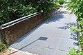
This pedestrian and cyclist bridge made of steel and wood connects Hans-Sachs-Straße with Südfeldmark. This is where the most unattractive part of the stream between shopping centers and parking lots begins. Looking north. (July 27, 2011)

Tunnel under Dringenberger Strasse. When stooped, even an adult can go through. Look downstream. (July 26, 2011)

Double tunnel under the street “Im Kreuzbruch”. The opportunities for aquatic animals to migrate are restricted. However, the stream is still steep enough here that it naturally forms comparable steps when the water is low. (July 27, 2011)

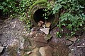
Tunnel under the B 64 at the Uhlenmühle. Approx. 50 m long and only about 1.5 m in diameter. In winter it builds up here. In the event of flooding, the stream has the option of using the Am Bischofswasser road tunnel , which runs to the left of it. Look downstream. (July 23, 2011)

This approx. 15 m long, narrow pipe lies between the B 64 and Uhlenmühle. At this length it is perhaps the most senseless construction of the Hilgenbach, as only a meadow is reached via this transition. Look downstream. (July 23, 2011)

This private wooden bridge leads to the site of the former Uhlenmühle. Facing south. (July 23, 2011)

Wooden footbridge. This foot and cycle path bypasses the Uhlenmühle property today, as this is private property. Look downstream. (July 23, 2011)

The street Zum Hillenwasser , coming from the left of the city, is a popular walk in the Hilgenbachaue. Side streams flow from both sides directly in front of the bridge. Look downstream. (July 23, 2011)

A forest path leads from the B 64 over this bridge at Josefsmühle in the direction of Kohlberg and Düsenberg. The new bridge was built in 2010. Before that there was this natural stone bridge . Look upstream. (July 23, 2011)

Tunnel under the B 64 at Josefsmühle. The streambed fastened with grass grids. Look upstream. (July 23, 2011)

Agricultural bridge just before the confluence with the Aa. It connects the fields on both sides of the stream. Facing south. (July 23, 2011)


Web links
- www.kreis-hoexter.de:Erlebnisgebiet Iburg-Aschenhütte - excursion tip
- www.wefish.de: Fishing pictures from the Bad Driburg town pond - The town pond belongs to the catchment area via Katzohlbach.
Individual evidence
- ↑ a b c Topographic map 1: 25,000
- ^ A b Lower Saxony's Ministry for the Environment, Energy and Climate Protection: Hydrographic map of Lower Saxony
- ↑ a b http://www.fisdt.de/wrrl/page/Gewaesser/gewseite.php?fg=45262 ( page no longer available , search in web archives ) Info: The link was automatically marked as defective. Please check the link according to the instructions and then remove this notice.
- ↑ http://www.naturschutz-fachinformationssysteme-nrw.de/natura2000-meldedok/de/fachinfo/listen/meldedok/DE-4219-303
- ↑ a b http://www.elwasims.nrw.de/ ( page no longer available , search in web archives ) Info: The link was automatically marked as defective. Please check the link according to the instructions and then remove this notice.
- ↑ Information board of the Eggegebirgsverein, Kunkelhütte location
- ↑ Information board of the Eggegebirgsverein, Kaplansborn location
- ↑ a b http://www.lanuv.nrw.de/fileadmin/lanuv/wasser/pdf/Gewaesserverzeichnis%20GSK3C.xls
- ↑ Official Journal of the City of Bad Driburg: No. 19, May 13, 2010
- ↑ Information board of the Bad Driburger Sportangler Verein, location city pond
- ↑ a b c d e f g h Geoscientific community descriptions NRW Bad Driburg ( Memento from March 1, 2014 in the Internet Archive )
- ↑ a b c d e f g h i http://www.paderborn.de/microsite/naturkundemuseum/download/00-71-NATVM09.pdf
- ↑ a b c d e topographic map 1: 10,000
- ↑ a b c d e f g Page no longer available , search in web archives: Flood report district government Detmold
- ^ Bad Driburg news: The mayor informs. (PDF (6.13MB)) Westfalenblatt, May 20, 2010, accessed on April 30, 2017 .
- ↑ http://www.nw-news.de/lokale_news/hoexter/hoexter/3782906_50.000_Pflanzen_reinigen_das_Wasser.html
- ↑ Information from the district government ( Memento of the original dated May 29, 2014 in the Internet Archive ) Info: The archive link was inserted automatically and has not yet been checked. Please check the original and archive link according to the instructions and then remove this notice.
- ↑ Archive link ( Memento of the original from June 10, 2011 in the Internet Archive ) Info: The archive link was inserted automatically and has not yet been checked. Please check the original and archive link according to the instructions and then remove this notice.