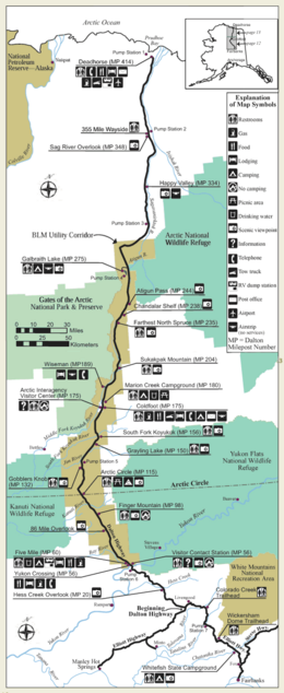
Dalton Highway
The Dalton Highway (Alaska Route 11) was built in 1974 within five months and connects Fairbanks in central Alaska with Deadhorse near the Beaufort Sea . The highway begins at a junction with the Elliott Highway and then leads 666 km north through largely deserted and - with the exception of the Trans-Alaska Pipeline , which runs parallel to it for long distances - untouched nature. The road is unpaved and is often in poor condition due to the severe winter. There are no towns along the highway. The few settlements are service stations for the trucks of the oil production companies. Between Coldfoot and Deadhorse there are no supply options on a 384 kilometer stretch.
The highway ends a few kilometers from the Arctic Ocean, in Deadhorse. From here, only vehicles with special rights are allowed to drive to the oil production facilities in Prudhoe Bay . After the highway was built, only the first 89 kilometers from Fairbanks to the Yukon River , and later another 251 kilometers to Disaster Creek, were open to public transport. Since 1991 private individuals have also been allowed to drive to Deadhorse.
Apart from the Dalton Highway, the Dempster Highway in the Canadian Yukon is only another highway in North America that crosses the Arctic Circle. The highway was named after James W. Dalton , an engineer who worked on early oil exploration in the region.
course
- 0 km: The highway begins north of Fairbanks
- 0–24 km: The Taps
- 34 km: Hess-Creek, rest area (viewpoint)
- 39 km: Hess Creek
- 87 km: Pump station No. 6 of the pipeline
- 90 km: Crossing the Yukon (EL Patton Yukon River Bridge), information center and gas station
- 98 km: Hot Spot Cafe
- 100 km: 7 Mile Camp of the Alaska Department of Transportation
- 117 km: Hamlin Hills Creek
- 122 km: Roller Coaster
- 127 km: No Name Creek
- 146 km: Dall Creek
- 158 km: Finger Mountain
- 171 km: Bridge over the Kanuti River
- 177 km: Beaver Slide
- 183 km: Fish Creek
- 186 km: Arctic Circle , rest area
- 192 km: Alder Mountain
- 195 km: Connection Rock
- 201–202 km: Bridges over Bonanza Creek
- 202 km: Oh Shit Corner
- 208 km: Two and a Half Mile
- 212 km: Gobblers Knob
- 217 km: Prospect Creek
- 219 km: Winter road junction to Bettles
- 221 km: Pump station No. 5 of the pipeline
- 223 km: Jim River Camp of the Alaska Department of Transportation
- 225–232 km: Bridges over the Jim River
- 229 km: Douglas Creek
- 150 miles: Grayling Lake, rest area
- 251 km: Bridge over the Koyukuk River
- 253 km: Koyukuk
- 279 km: Coldfoot settlement (old gold mining village on the Koyukuk River )
- 284 km: Slate Creek
- 290 km: Marion Creek
- 304 km: Wiseman settlement (old gold mining village on the Brooks chain )
- 330 km: rest area
- 331 km: Bridge over the Koyukuk River
- 334 km: Bridge over the Dietrich River
- 336 km: Sukakpak Mountain
- 340 km: Dietrich Camp
- 370 km: Nutriwik Creek
- 383 km: rest area
- 385 km: Chandalar Shelf ("The Shelf")
- 387 km: Chandalar Camp of the Alaska Department of Transportation
- 395 km: Bridge over the Chandalar River
- 396–402 km: avalanche zone (around 40 avalanche slopes)
- 399 km: Continental watershed at Atigun Pass
- 406 km: Atigun Camp
- 410 km: Bridge over the Atigun River
- 418 km: Trevor Creek
- 430 km: Roche Mountonee Creek
- 433 km: Pump station No. 4 of the pipeline
- 433 km: Holden Creek
- 443 km: Galbraith Lake
- 443 km: Toolik Lake
- 447 km: Island Lake
- 463 km: Toolik Hill
- 467 km: Bridge over the Kuparuk River
- 494 km: Sag River Camp of the Alaska Department of Transportation
- 502 km: Pump station No. 3 of the pipeline
- 516 km: Oil Spill Hill
- 526 km: Ice Cut
- 534 km: Dan Creek
- 541 km: Happy Valley
- 560 km: Sag River Viewpoint
- 573 km: Roadside rest area
- 577 km: Pump station No. 2 of the pipeline
- 610 km: Franklin Bluffs ("The Bluffs")
- 666 km: Deadhorse settlement (supply camp for the oil workers)
photos
Dalton Highway north of the Continental Divide at mile 256 on the Brooks Range
Between Atigun Pass and Deadhorse , the highway runs parallel to the Sagavanirkenok River
Highway and Chandalar Shelf on the upper reaches of the Chandalar River
Sunrise east of Gates of the Arctic National Park
Web links
- Bureau of Land Management: Dalton Highway (English)
- During the Dalton Highway on Bell's Travel Guide (English)
- Webcams Dalton Highway DOT Webcams (English)


