Alei
|
Alei Алей |
||
| Data | ||
| Water code | RU : 13010200112115200000028 | |
| location | Altai Region ( Russia ) | |
| River system | If | |
| Drain over | Whether → Arctic Ocean | |
| source | northwestern foothills of the Altai 50 ° 44 ′ 43 ″ N , 82 ° 29 ′ 0 ″ E |
|
| muzzle | near Ust-Aleika south of Barnaul in the Ob coordinates: 52 ° 51 ′ 16 ″ N , 83 ° 36 ′ 59 ″ E 52 ° 51 ′ 16 ″ N , 83 ° 36 ′ 59 ″ E
|
|
| length | 858 km | |
| Catchment area | 21,100 km² | |
| Discharge at the Aleisk A Eo gauge : 18,700 km² Location: 155 km above the estuary |
MQ 1954/2000 Mq 1954/2000 |
30 m³ / s 1.6 l / (s km²) |
| Discharge at the gauge Chabasino A Eo : 20,800 km² Location: 46 km above the mouth |
MQ 1936/1955 Mq 1936/1955 |
34 m³ / s 1.6 l / (s km²) |
| Left tributaries | Klepechikha | |
| Big cities | Rubtsovsk | |
| Medium-sized cities | Aleisk | |
| Small towns | Pospelicha | |
| Communities | Staroaleiskoje | |
|
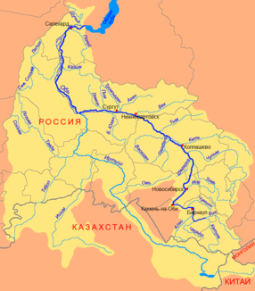
Course of the Alei (Алей) as the left tributary of the Ob |
||
The 858 km long Alei ( Russian Але́й ; also Alej ) is a left tributary of the Ob in Siberia ( Russia , Asia ).
The Alei (in the upper reaches: Eastern Alei, Russian Восто́чный Але́й / Wostotschny Alei ) rises in the northwestern foothills of the Altai on the border with Kazakhstan . In the further course it flows strongly meandering through the steppes of the northern Altai foreland in the area of the Altai region and flows into the Ob near the village of Ust-Aleika south of Barnaul . Near the mouth, the river is approx. 70 m wide and 1.5 m deep.
The catchment area covers 21,100 km². The mean monthly water flow at Chabasino 46 km before the mouth is 34.0 m³ / s (in February only an average of 3.5 m³ / s, in May, however, an average of 144.1 m³ / s).
The alei freezes from November to April. Its water is used to irrigate agricultural areas.
The cities of Rubtsovsk and Aleisk are located on the Alei .
Individual evidence
- ↑ a b Article Alei in the Great Soviet Encyclopedia (BSE) , 3rd edition 1969–1978 (Russian)
- ↑ a b Alei in the State Water Register of the Russian Federation (Russian)
- ↑ Alei at the Aleisk gauge - hydrographic data from R-ArcticNET
- ↑ a b Alei at the Chabasino gauge - hydrographic data at R-ArcticNET

