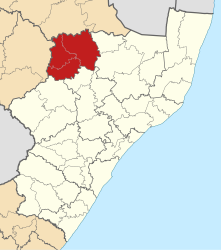
Amajuba
| Amajuba Amajuba District Municipality |
||
|---|---|---|
 |
||
| Symbols | ||
|
||
| Basic data | ||
| Country | South Africa | |
| province | KwaZulu-Natal | |
| Seat | Newcastle | |
| surface | 6911 km² | |
| Residents | 499,839 (October 2011) | |
| density | 72 inhabitants per km² | |
| key | DC25 | |
| ISO 3166-2 | ZA-KZN | |
| Website | www.amajuba.gov.za (English) | |
| politics | ||
| mayor | Musa Mgubane | |
Coordinates: 27 ° 45 ′ S , 29 ° 55 ′ E
Amajuba is a district within the KwaZulu-Natal Province in South Africa . In 2011 the population was 499,839 on a total area of 6,911 km². The district administration is based in Newcastle .
Amajuba is the Zulu word meaning "a place of the doves" (a place of peace).
Around 40 percent of the population are infected with HIV / AIDS . Since the 20 to 40-year-olds are primarily affected, the age structure of the country is falling apart. In many cases families break up, leaving behind the socially marginalized AIDS orphans.
Community structure
As an example of the infrastructure here is the water supply for households (HWA = own domestic water connection; ÖWA = public water connection nearby; KWA = no connection to a water supply network):
| local community | Administrative headquarters | surface | Residents | HWA | Ö WA | KWA |
|---|---|---|---|---|---|---|
| Dannhauser | Dannhauser | 1516 km² | 102,771 | 4% | 32% | 64% |
| eMadlangeni | Utrecht | 3593 km² | 32,268 | 11% | 28% | 61% |
| Newcastle | Newcastle | 1855 km² | 332.971 | 14% | 70% | 16% |
Web links
- The district website (English)
Individual evidence
- ↑ Meaning of the name municipalities
- ^ Aids statistics of the community ( Memento from September 26, 2006 in the Internet Archive )
- ^ Community statistics South Africa ( Memento from April 26, 2009 in the Internet Archive )
