Newcastle (parish)
| Newcastle Newcastle Local Municipality |
||
|---|---|---|
 |
||
| Symbols | ||
|
||
| Basic data | ||
| Country | South Africa | |
| province | KwaZulu-Natal | |
| District | Amajuba | |
| Seat | Newcastle | |
| surface | 1,855.3 km² | |
| Residents | 363,236 (October 2011) | |
| density | 196 inhabitants per km² | |
| key | KZN252 | |
| ISO 3166-2 | ZA-KZN | |
| Website | www.newcastle.gov.za (English) | |
| politics | ||
| mayor | Makhosini Nkosi | |
| Political party | African National Congress | |
Coordinates: 27 ° 45 ′ S , 29 ° 55 ′ E
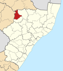
Newcastle ( English Newcastle Local Municipality ) is a municipality in the South African district of Amajuba and the third largest urban center in the province of KwaZulu-Natal . The municipality's administrative headquarters are in the city of Newcastle . Aszul Rehman is the mayor. The ANC has the majority in the local council.
The namesake of the municipality and the city was the Duke of Newcastle , a former British Secretary of State for the colonies. The parish covers an area of 1855 square kilometers. In 2011 the community had 363,236 inhabitants according to the census.
geography
Newcastle is the largest of three parishes in the district. It is located in the northwest of the province on the Ncandu River at the foot of the Drakensberg . It borders the Mpumalanga Province to the north and eMadlangeni to the northeast . Dannhauser is south of Newcastle and the province of Free State to the west .
Parts of Chelmsford Dam belong to Newcastle, which forms part of the southern parish boundary. Another reservoir is the Amcor Dam . In the northeast, Newcastle is delimited by the Buffalo River .
places
- Charlestown
- Madadeni
- Newcastle
- Osizweni
economy
The N11 national road runs through Newcastle and connects the parish with Gauteng in the north and Ladysmith and eThekwini in the south. The national road is surrounded by a corridor in which a large part of the municipality's industry is located. From east to west, Newcastle is connected to the surrounding communities by the R34 .
Originally, manufacturing, mining and social services made up the majority of the economic output of the Newcastle region. Especially when the former state-owned company ISCOR settled in the city after large coal discoveries . However, the manufacturing industry and mining are declining. Private households are now the main employer in the municipality. Despite the uncertainty in the manufacturing industry, textile companies are still a very important employer in the region. The textile industry is mainly supported by Chinese and Taiwanese investors.
Much of the municipality is used as uncultivated pastureland. In addition, agriculture and forestry are practiced.
population
In 2011 the community had 363,236 inhabitants. 91.9% of them were black, 3.9% white, 3.2% Indian or Asian and 0.8% colored .
The first language was 84.9% isiZulu , 6.3% English, 3.5% Afrikaans and 0.9% isiNdebele .
Attractions
Newcastle is close to the Battlefield Route, which has many historical theaters of war. There are also some old buildings to visit, such as the town hall from 1897, which is a listed building. The building of the Carnegie Art Gallery , an art gallery from 1915, is also a national monument. The museum exhibits contemporary South African art.
Web links
- Official website (English)
- The Local Government Handbook: Newcastle Local Municipality (KZN252 )
- Newcastle Local Municipality. KwaZulu-Natal Top Business , accessed June 6, 2010 .
- Integrated Development Plan. (doc; MB) Newcastle City, accessed June 6, 2010 (English).
Individual evidence
- ↑ a b Newcastle Municipality (Ed.), P. 7.
- ↑ Contact information: Newcastle Local Municipality. (No longer available online.) Government Communication and Information System , archived from the original on September 2, 2011 ; accessed on February 7, 2010 (English). Info: The archive link was inserted automatically and has not yet been checked. Please check the original and archive link according to the instructions and then remove this notice.
- ^ The Local Government Handbook - A complete guide to municipalities in South Africa. Newcastle Local Municipality (KZN252). Yes! Media, accessed December 26, 2016 .
- ↑ a b c d e KwaZulu-Natal Top Business (ed.).
- ^ Newcastle. (No longer available online.) Municipal Demarcation Board , formerly original ; accessed on June 6, 2010 (English). ( Page no longer available , search in web archives ) Info: The link was automatically marked as defective. Please check the link according to the instructions and then remove this notice.
- ↑ a b c Ward Delimitation 2009 - Supplementary Map. Municipal Demarcation Board , accessed June 6, 2010 .
- ↑ http://www.statssa.gov.za/?page_id=993&id=newcastle-municipality
