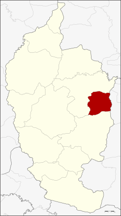
Kae Dam district
|
Kae Dam แกดำ |
|
|---|---|
| Province: | Maha Sarakham |
| Surface: | 149.5 km² |
| Residents: | 29,810 (2013) |
| Population density : | 195.4 U / km² |
| ZIP : | 44190 |
| Geocode : | 4402 |
| map | |

|
|
Amphoe Kae Dam ( Thai อำเภอ แกดำ ) is a district ( Amphoe - administrative district) in the east of the province of Maha Sarakham . The province of Maha Sarakham is located in the center of the northeast region of Thailand , the so-called Isan .
geography
Amphoe Kae Dam borders the following districts (clockwise from the south): Amphoe Wapi Pathum and Mueang Maha Sarakham in the province of Maha Sarakham, and Amphoe Si Somdet in the province of Roi Et .
history
Kae Dam was initially set up on January 3, 1977 as a “branch circle” ( King Amphoe ) by separating the three tambon Kae Dam, Nong Kung and Mittraphap from the Mueang Maha Sarakham district . On January 1, 1988, it was promoted to Amphoe.
administration
Provincial Administration
Kae Dam County is divided into five tambon ("subdistricts" or "municipalities"), which are further subdivided into 89 muban ("villages").
| No. | Surname | Thai | Muban | Pop. |
|---|---|---|---|---|
| 1. | Kae Dam | แกดำ | 18th | 8,863 |
| 2. | Wang Saeng | วัง แสง | - | 5,942 |
| 3. | Mittraphap | มิตรภาพ | 21st | 6,797 |
| 4th | Nong Kung | หนอง กุ ง | - | 4,330 |
| 5. | Non Phiban | โนน ภิ บาล | 14th | 3,878 |
Note: Some of the Muban's data are not yet available.
Local administration
There are two municipalities with "small town" status ( Thesaban Tambon ) in the district:
- Kae Dam (Thai: เทศบาล ตำบล แกดำ ), consisting of parts of the Tambon Kae Dam.
- Mittraphap (Thai: เทศบาล ตำบล มิตรภาพ ), consisting of the entire tambon Mittraphap.
There are also four " Tambon Administrative Organizations " ( องค์การ บริหาร ส่วน ตำบล - Tambon Administrative Organizations, TAO):
- Kae Dam (Thai: องค์การ บริหาร ส่วน ตำบล แกดำ )
- Wang Saeng (Thai: องค์การ บริหาร ส่วน ตำบล วัง แสง )
- Nong Kung (Thai: องค์การ บริหาร ส่วน ตำบล หนอง กุ ง )
- Non Phiban (Thai: องค์การ บริหารส่วน ตำบล โนน ภิ บาล )
Individual evidence
- ↑ ประกาศ กระทรวง มหาดไทย เรื่อง แบ่ง ท้องที่ อำเภอ เมือง มหาสารคาม จังหวัด มหาสารคาม ตั้ง เป็น กิ่ง อำเภอ แกดำ . In: Royal Gazette . 94, No. 4 ง , January 11, 1977, p. 118.
- ↑ พระราชกฤษฎีกา ตั้ง อำเภอ นาม น อำเภอ พระยืน อำเภอ หนองบัว ระ เหว อำเภอ บ้านเหลื่อม อำเภอ จะ แนะ อำเภอ หนอง หงส์ อำเภอ นา โพธิ์ อำเภอ เกาะยาว อำเภอ อำเภอ แกดำ อำเภอ สระ โบสถ์ อำเภอ อำเภอ โนน คูณ อำเภอ ควนโดน อำเภอ ไชยวาน อำเภอ หนอง แสง และ อำเภอ ตาล สุม พ.ศ. ๒๕๓๐ . In: Royal Gazette . 104, No. 278 ก ฉบับ พิเศษ (special), December 31, 1987, pp. 33-37.
- ↑ 2013 population statistics ( Thai ) Department of Provincial Administration. Retrieved July 29, 2014.
Web links
Coordinates: 16 ° 1 ' N , 103 ° 23' E
