Amphoe Na Dun
|
Well Dun นาดูน |
|
|---|---|
| Province: | Maha Sarakham |
| Surface: | 248.449 km² |
| Residents: | 37,294 (2013) |
| Population density : | 146.9 U / km² |
| ZIP : | 44180 |
| Geocode : | 4410 |
| map | |

|
|
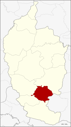
Amphoe Na Dun (in Thai อำเภอ นาดูน ) is a district ( Amphoe - administrative district) in the south of the province of Maha Sarakham . The province of Maha Sarakham is located in the center of the northeast region of Thailand , the so-called Isan .
geography
Na Dun District borders the following districts are (from south clockwise) to the Amphoe Phayakkhaphum Phisai , Yang Sisurat , Na Chueak and Wapi Pathum in the province of Maha Sarakham and to Amphoe Pathum Council of the province of Roi Et .
history
Na Dun was initially set up on October 1, 1969 as a "branch circle" ( King Amphoe ) by separating the three tambon Na Dun, Nong Phai and Nong Khu from the Amphoe Wapi Pathum. It was promoted to Amphoe on March 25, 1979.
administration
Provincial Administration
The district of Na Dun is divided into nine tambon ("subdistricts" or "municipalities"), which are further subdivided into 94 Muban ("villages").
| No. | Surname | Thai | Muban | Pop. |
|---|---|---|---|---|
| 1. | Well Dun | นาดูน | 10 | 4,656 |
| 2. | Nong Phai | หนองไผ่ | 8th | 3,868 |
| 3. | Nong Khu | หนอง คู | 14th | 5,738 |
| 4th | Dong bang | ดง บัง | 9 | 2,709 |
| 5. | Dong Duan | ด งด วน | 10 | 4,024 |
| 6th | Hua Dong | หัว ดง | 15th | 5,178 |
| 7th | Dong Yang | ดง ยาง | 11 | 4,360 |
| 8th. | Ku Santarat | กู่ สัน ต รัตน์ | 9 | 3,796 |
| 9. | Phra That | พระ ธาตุ | 8th | 2,965 |
Local administration
There are three municipalities with "small town" status ( Thesaban Tambon ) in the district:
- Na Dun (Thai: เทศบาล ตำบล นาดูน ), consisting of parts of the Tambon Na Dun and Phra That.
- Hua Dong (Thai: เทศบาล ตำบล หัว ดง ), consisting of the entire Tambon Hua Dong.
- Nong Phai (Thai: เทศบาล ตำบล หนองไผ่ ), consisting of the entire Tambon Nong Phai.
There are also six " Tambon Administrative Organizations " ( องค์การ บริหาร ส่วน ตำบล - Tambon Administrative Organizations, TAO):
- Nong Khu (Thai: องค์การ บริหาร ส่วน ตำบล หนอง คู )
- Dong Bang (Thai: องค์การ บริหาร ส่วน ตำบล ดง บัง )
- Dong Duan (Thai: องค์การ บริหาร ส่วน ตำบล ด งด วน )
- Dong Yang (Thai: องค์การ บริหาร ส่วน ตำบล ดง ยาง )
- Ku Santarat (Thai: องค์การ บริหารส่วน ตำบล กู่ สัน ต รัตน์ )
- Phra That (Thai: องค์การ บริหาร ส่วน ตำบล พระ ธาตุ )
Individual evidence
- ↑ ประกาศ กระทรวง มหาดไทย เรื่อง แบ่ง ท้องที่ ตั้ง เป็น กิ่ง อำเภอ . In: Royal Gazette . 86, No. 91 ง , October 21, 1969, p. 3118.
- ↑ พระราชกฤษฎีกา ตั้ง อำเภอ หนองกุงศรี อำเภอ ไทรงาม อำเภอ บ้านฝาง อำเภอ อุบลรัตน์ อำเภอ เวียงชัย อำเภอ ดอยเต่า อำเภอ นิคมคำสร้อย อำเภอ นาหว้า อำเภอ เสิงสาง อำเภอ ศรีสาคร อำเภอ บึงสามพัน อำเภอ นาดูน อำเภอ อำเภอ ค้อวัง อำเภอ โพธิ์ชัย อำเภอ อำเภอ เมืองสรวง อำเภอ ปลวกแดง อำเภอ ยางชุมน้อย อำเภอ กาบเชิง อำเภอ สุวรรณคูหา และ อำเภอ กุดข้าวปุ้น พ.ศ. ๒๕๒๒ . In: Royal Gazette . 96, No. 42 ก ฉบับ พิเศษ (special), March 25, 1979, pp. 19-24.
- ↑ 2013 population statistics ( Thai ) Department of Provincial Administration. Retrieved July 30, 2014.
Web links
Coordinates: 15 ° 43 ' N , 103 ° 14' E
