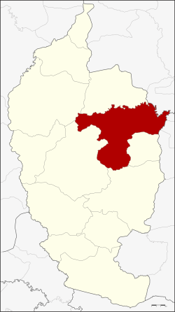
Amphoe Mueang Maha Sarakham
|
Amphoe Mueang Maha Sarakham อำเภอ เมือง มหาสารคาม |
|
|---|---|
| Province: | Maha Sarakham |
| Surface: | 556.7 km² |
| Residents: | 154,254 (2013) |
| Population density : | 255.7 U / km² |
| ZIP : | 44000 |
| Geocode : | 4401 |
| map | |

|
|
Amphoe Mueang Maha Sarakham ( Thai : อำเภอ เมือง มหาสารคาม ) is a district ( amphoe - administrative district) in the province of Maha Sarakham . The province of Maha Sarakham is located in the northeast region of Thailand , the so-called Isan .
geography
Maha Sarakham is located in the heart of the Isan, in the middle of the Khorat plateau . The distance to the capital Bangkok is about 450 kilometers.
Neighboring districts (from the south clockwise): the Amphoe Kae Dam , Wapi Pathum , Borabue , Kosum Phisai and Kantharawichai of the province of Maha Sarakham, Amphoe Khong Chai of the province of Kalasin and the Amphoe Changhan , Mueang Roi Et and Si Somdet of the province of Roi Et .
history
The district was renamed from Uthai Sarakham to Mueang Maha Sarakham in 1913.
education
The Maha Sarakham Rajabhat University is located in Amphoe Mueang Maha Sarakham .
administration
Provincial Administration
Mueang Maha Sarakham County is divided into 14 tambon ("subdistricts" or "parishes"), which are further subdivided into 185 Muban ("villages").
| No. | Surname | Thai | Muban | Pop. |
|---|---|---|---|---|
| 1. | Talat | ตลาด | - | 48,765 |
| 2. | Khwao | เข วา | 24 | 14,728 |
| 3. | Tha Tum | ท่าตูม | - | 5,228 |
| 4th | Waeng Nang | แวง น่า ง | 17th | 14,195 |
| 5. | Khok Ko | โคก ก่อ | 16 | 8,163 |
| 6th | Don Wan | ดอน หว่าน | 9 | 5,008 |
| 7th | Koeng | เกิ้ง | 14th | 9,082 |
| 8th. | Kaeng Loeng Chan | แก่ง เลิ ง จาน | 2 | 8,111 |
| 9. | Tha Song Khon | ท่า สอง คอน | - | 13,291 |
| 10. | Lat Phatthana | ลาด พัฒนา | 19th | 7,489 |
| 11. | Nong Pling | หนอง ปลิง | 8th | 5.119 |
| 12. | Huai Aeng | ห้วย แอ่ง | - | 3,635 |
| 13. | Nong No. | หนอง โน | - | 5,885 |
| 14th | Bua Kho | บัว ค้อ | - | 5,555 |
Note: Some of the Muban's data are not yet available.
Local administration
There is one commune with "city" status ( Thesaban Mueang ) in the district:
- Maha Sarakham (Thai: เทศบาล เมือง มหาสารคาม ) comprises the entire Tambon Talat.
There is one municipality with "small town" status ( Thesaban Tambon ) in the district:
- Waeng Nang (Thai: เทศบาล ตำบล แวง น่า ง ) consists of parts of the Tambon Waeng Nang.
There are also 13 " Tambon Administrative Organizations " ( องค์การ บริหาร ส่วน ตำบล - Tambon Administrative Organizations, TAO):
- Khwao (Thai: องค์การ บริหาร ส่วน ตำบล เข วา )
- Tha Tum (Thai: องค์การ บริหาร ส่วน ตำบล ท่าตูม )
- Waeng Nang (Thai: องค์การ บริหาร ส่วน ตำบล แวง น่า ง )
- Khok Ko (Thai: องค์การ บริหาร ส่วน ตำบล โคก ก่อ )
- Don Wan (Thai: องค์การ บริหาร ส่วน ตำบล ดอน หว่าน )
- Koeng (Thai: องค์การ บริหาร ส่วน ตำบล เกิ้ง )
- Kaeng Loeng Chan (Thai: องค์การ บริหาร ส่วน ตำบล แก่ง เลิ ง จาน )
- Tha Song Khon (Thai: องค์การ บริหาร ส่วน ตำบล ท่า สอง คอน )
- Lat Phatthana (Thai: องค์การ บริหาร ส่วน ตำบล ลาด พัฒนา )
- Nong Pling (Thai: องค์การ บริหาร ส่วน ตำบล หนอง ปลิง )
- Huai Aeng (Thai: องค์การ บริหาร ส่วน ตำบล ห้วย แอ่ง )
- Nong No (Thai: องค์การ บริหาร ส่วน ตำบล หนอง โน )
- Bua Kho (Thai: องค์การ บริหาร ส่วน ตำบล บัว ค้อ )
Individual evidence
- ↑ แจ้ง ความ กระทรวง มหาดไทย เรื่อง เปลี่ยน นาม อำเภอ . In: Royal Gazette . 30, No. 0 ง , October 19, 1913, pp. 1619–1620.
- ↑ 2013 population statistics ( Thai ) Department of Provincial Administration. Retrieved July 29, 2014.
Web links
Coordinates: 16 ° 11 ′ N , 103 ° 18 ′ E
