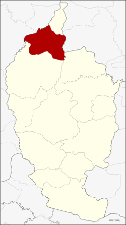
Chiang Yuen Amphoe
|
Chiang Yuen เชียงยืน |
|
|---|---|
| Province: | Maha Sarakham |
| Surface: | 289.0 km² |
| Residents: | 61,528 (2013) |
| Population density : | 214.5 U / km² |
| ZIP : | 44160 |
| Geocode : | 4405 |
| map | |

|
|
Amphoe Chiang Yuen ( Thai อำเภอ เชียงยืน ) is a district ( Amphoe - Administrative District) in the north of the Maha Sarakham Province . The province of Maha Sarakham is located in the center of the northeast region of Thailand , the so-called Isan .
geography
Chiang Yuen District borders the following districts (from north clockwise) to Amphoe Chuen Chom in the province of Maha Sarakham to Amphoe Yang Talat the province of Kalasin , the Amphoe Kantharawichai and Kosum Phisai turn in Maha Sarakham and to the Amphoe Mueang Khon Kaen and Sam Sung of Khon Kaen Province .
history
Amphoe Chiang Yuen was initially set up as a “branch circle” ( King Amphoe ) on August 16, 1958 , by separating the four tambon Chiang Yuen, Chuen Chom, Ku Thong and Nong Son from the Amphoe Kantharawichai. On December 11, 1959, it was promoted to Amphoe.
administration
Provincial Administration
Chiang Yuen County is divided into eight tambon ("subdistricts" or "parishes"), which are further subdivided into 66 muban ("villages").
| No. | Surname | Thai | Muban | Pop. |
|---|---|---|---|---|
| 1. | Chiang Yuen | เชียงยืน | 19th | 13,639 |
| 3. | Nong Son | หนอง ซอน | 16 | 6,852 |
| 5. | Don Ngoen | ดอน เงิน | 15th | 7.131 |
| 6th | Ku Thong | กู่ ทอง | 19th | 10,203 |
| 7th | Well thong | นาทอง | 11 | 5,612 |
| 8th. | Suea Thao | เสือ เฒ่า | 16 | 8,364 |
| 11. | Phon Thong | โพนทอง | 12 | 6,034 |
| 12. | Lao Bua Ban | เหล่า บัว บาน | 8th | 3,693 |
Note: the missing numbers (geocodes) refer to tambon, which today belong to Chuen Chom.
Local administration
There are two municipalities with "small town" status ( Thesaban Tambon ) in the district:
- Chiang Yuen (Thai: เทศบาล ตำบล เชียงยืน ), consisting of parts of the Tambon Chiang Yuen,
- Phon Thong (Thai: เทศบาล ตำบล โพนทอง ), consisting of the entire tambon Phon Thong.
There are also seven " Tambon Administrative Organizations " ( องค์การ บริหาร ส่วน ตำบล - Tambon Administrative Organizations, TAO):
- Chiang Yuen (Thai: องค์การ บริหาร ส่วน ตำบล เชียงยืน )
- Nong Son (Thai: องค์การ บริหาร ส่วน ตำบล หนอง ซอน )
- Don Ngoen (Thai: องค์การ บริหาร ส่วน ตำบล ดอน เงิน )
- Ku Thong (Thai: องค์การ บริหาร ส่วน ตำบล กู่ ทอง )
- Na Thong (Thai: องค์การ บริหาร ส่วน ตำบล นาทอง )
- Suea Thao (Thai: องค์การ บริหาร ส่วน ตำบล เสือ เฒ่า )
- Lao Bua Ban (Thai: องค์การ บริหาร ส่วน ตำบล เหล่า บัว บาน )
Individual evidence
- ↑ ประกาศ กระทรวง มหาดไทย เรื่อง ยก ฐานะ ตำบล ขึ้น เป็น กิ่ง อำเภอ . In: Royal Gazette . 75, No. 70 ง , September 9, 1958, p. 2487.
- ↑ พระราชกฤษฎีกา ตั้ง อำเภอ ชุมพวง อำเภอ เชียงยืน อำเภอ แก้ง ค ร้ อ อำเภอ สำโรงทาบ อำเภอ คอน สาร อำเภอ เซกา อำเภอ ทุ่งเสลี่ยม อำเภอ บ้าน ด่าน ด่าน อำเภอ ขนอม อำเภอ บ้านแพรก อำเภอ กระทู้ และ อำเภอ คลองใหญ่ พ.ศ. ๒๕๐๒ . In: Royal Gazette . 76, No. 113 ก ฉบับ พิเศษ (special), January 10, 1959, p. 8.
- ↑ 2013 population statistics ( Thai ) Department of Provincial Administration. Retrieved July 30, 2014.
Web links
Coordinates: 16 ° 24 ' N , 103 ° 6' E
