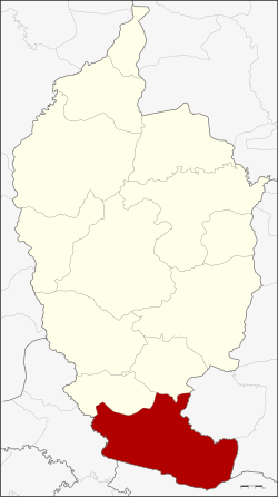
Amphoe Phayakkhaphum Phisai
|
Phayakkhaphum Phisai พยัคฆภูมิพิสัย |
|
|---|---|
| Province: | Maha Sarakham |
| Surface: | 409.783 km² |
| Residents: | 87,753 (2013) |
| Population density : | 214.5 U / km² |
| ZIP : | 44110 |
| Geocode : | 4408 |
| map | |

|
|
Amphoe Phayakkhaphum Phisai (in Thai อำเภอ พยัคฆภูมิพิสัย ) is a district ( Amphoe - administrative district) in the south of the province of Maha Sarakham . The province of Maha Sarakham is located in the center of the northeast region of Thailand , the so-called Isan .
geography
Phayakkhaphum phisai district borders the following districts (from north clockwise) to the Amphoe Yang Sisurat and Na Dun in the province of Maha Sarakham, to the Amphoe Pathum Rat and Kaset Wisai the province of Roi Et , at Amphoe Chumphon Buri the province of Surin , and at Amphoe Phutthaisong the province of Buriram .
administration
Provincial Administration
Phayakkhaphum Phisai County is divided into 14 tambon (“subdistricts” or “parishes”), which are further subdivided into 227 muban (“villages”).
| No. | Surname | Thai | Muban | Pop. |
|---|---|---|---|---|
| 1. | Palan | ปะ หลาน | 16 | 11,267 |
| 2. | Came Pooh | ก้ามปู | 17th | 6,866 |
| 3. | Wiang Sa-at | เวียง สะอาด | 21st | 6,041 |
| 4th | Mek Dam | เม็ก ดำ | 22nd | 9,699 |
| 5. | Well Si Nuan | นา สี นวล | 14th | 5,885 |
| 9. | Council Charoen | ราษฎร์ เจริญ | 14th | 4,979 |
| 10. | Nong Bua Kaeo | หนองบัว แก้ว | 16 | 6.121 |
| 12. | Mueang Tao | เมือง เตา | 26th | 7,980 |
| 15th | Lan Sakae | ลาน สะแก | 19th | 7,043 |
| 16. | Wiang Chai | เวียงชัย | 14th | 3,962 |
| 17th | Nong Bua | หนองบัว | 13 | 5,669 |
| 18th | Council of Phatthana | ราษฎร์พัฒนา | 14th | 3,716 |
| 19th | Mueang Suea | เมือง เสือ | 11 | 4,418 |
| 20th | Phan Aen | ภาร แอ่น | 10 | 4,107 |
Note: Missing numbers (geocodes) refer to the tambon that belong to Yang Sisurat today.
Local administration
There is one municipality with "small town" status ( Thesaban Tambon ) in the district:
- Phayakkhaphum Phisai (Thai: เทศบาล ตำบล พยัคฆภูมิพิสัย ), consisting of parts of the Tambon Palan and Lan Sakae.
There are also 14 " Tambon Administrative Organizations " ( องค์การ บริหาร ส่วน ตำบล - Tambon Administrative Organizations, TAO):
- Palan (Thai: องค์การ บริหาร ส่วน ตำบล ปะ หลาน )
- Kam Pu (Thai: องค์การ บริหาร ส่วน ตำบล ก้ามปู )
- Wiang Sa-at (Thai: องค์การ บริหาร ส่วน ตำบล เวียง สะอาด )
- Mek Dam (Thai: องค์การ บริหาร ส่วน ตำบล เม็ก ดำ )
- Na Si Nuan (Thai: องค์การ บริหาร ส่วน ตำบล นา สี นวล )
- Rat Charoen (Thai: องค์การ บริหาร ส่วน ตำบล ราษฎร์ เจริญ )
- Nong Bua Kaeo (Thai: องค์การ บริหาร ส่วน ตำบล หนองบัว แก้ว )
- Mueang Tao (Thai: องค์การ บริหาร ส่วน ตำบล เมือง เตา )
- Lan Sakae (Thai: องค์การ บริหาร ส่วน ตำบล ลาน สะแก )
- Wiang Chai (Thai: องค์การ บริหาร ส่วน ตำบล เวียงชัย )
- Nong Bua (Thai: องค์การ บริหาร ส่วน ตำบล หนองบัว )
- Rat Phatthana (Thai: องค์การ บริหาร ส่วน ตำบล ราษฎร์พัฒนา )
- Mueang Suea (Thai: องค์การ บริหาร ส่วน ตำบล เมือง เสือ )
- Phan Aen (Thai: องค์การ บริหาร ส่วน ตำบล ภาร แอ่น )
Individual evidence
- ↑ 2013 population statistics ( Thai ) Department of Provincial Administration. Retrieved July 30, 2014.
Web links
Coordinates: 15 ° 31 ' N , 103 ° 12' E
