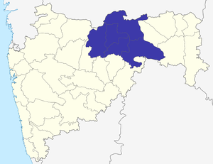
Amravati (Division)
| Amravati Division अमरावती विभाग |
|
|---|---|
| State : | Maharashtra |
| Coordinates | 20 ° 56 ' N , 77 ° 45' E |
| Administrative headquarters : | Amravati |
| Area : | 46,090 km² |
| Residents : | 9,941,903 |
| Population density : | 216 inhabitants / km² |
| Districts : | 5 |
Amravati is a division in the Indian state of Maharashtra . It is part of the Vidarbha region .
history
The division roughly coincides with the former Berar Province , which became part of Hyderabad State in 1803 . Since 1853 the area was administered by the British, who annexed it to the Central Provinces in 1903 . After India's independence, the area was initially assigned to Madhya Pradesh ; In 1956 a new boundary was drawn based on linguistic criteria. The area was assigned to the state of Bombay , to which it belonged until it was split into Gujarat and Maharashtra in 1960.
Districts
The Amravati division is divided into five districts:
| District | Capital | Area in km² | Population (as of 2001) | Population density in E / km² |
|---|---|---|---|---|
| Akola | Akola | 5,431 | 1,630,239 | 301 |
| Amravati | Amravati | 12,235 | 2,606,063 | 213 |
| Buldhana | Buldhana | 9,640 | ||
| Washim | Washim | 5,150 | 1,020,216 | 276 |
| Yavatmal | Yavatmal | 13,584 | 2,460,482 | 181 |
