Aranda (Spain)
| Aranda | |
|---|---|

|
|
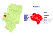
| Location of the comarca in the province of Saragossa | |
| Basic data | |
| Province: | Zaragoza |
| Main place: | Illueca (Zaragoza) |
| Surface: | 561 km² |
| Residents: | 6544 (2019) approx. 8,000 inhabitants |
| Municipalities: | 13 |
Aranda is a comarca ( administrative unit ) of the autonomous region of Aragon in Spain . It is located in the far west of the province of Saragossa and has about 8,000 inhabitants on an area of 561 km². Their main town is Illueca , the largest of the 13 municipalities in the comarca. The comarca belongs to the poorly populated Serranía Celtibérica .
location
The comarca is located south and southeast of the Sierra de Moncayo; it borders in the west on the province of Soria ( Campo de Gómara ), in the north on the comarcas Tarazona y el Moncayo and Campo de Borja , in the east on Valdejalón and in the south on the Comunidad de Calatayud . It is traversed by the Aranda and Isuela rivers.
Communities
In addition to Illueca , the comarca includes the municipalities of Aranda de Moncayo , Brea de Aragón , Calcena , Gotor , Jarque de Moncayo , Mesones de Isuela , Oseja , Pomer , Purujosa , Sestrica , Tierga and Trasobares .
economy
The comarca is rural and agricultural. The most important industry is the shoe production in Illueca and Brea de Aragón , the two largest towns.
history
In Illueca is the castle of the antipope Benedict XIII. ("Papa Luna", antipope 1394–1423); in Mesones de Isuela the imposing late medieval castle of a former bishop of Saragossa from the house of Luna rises from the 14th century. A crescent moon from the coat of arms of the House of Luna can be found in several municipal coats of arms of the comarcas Aranda and Calatayud.


