Gotor
| Gotor municipality | ||
|---|---|---|
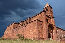
 Gotor - town view
|
||
| coat of arms | Map of Spain | |

|
|
|
| Basic data | ||
| Autonomous Community : | Aragon | |
| Province : | Zaragoza | |
| Comarca : | Aranda (Spain) | |
| Coordinates | 41 ° 33 ′ N , 1 ° 39 ′ W | |
| Height : | 600 msnm | |
| Area : | 15.52 km² | |
| Residents : | 318 (Jan. 1, 2019) | |
| Population density : | 20.49 inhabitants / km² | |
| Postal code : | 50257 | |
| Municipality number ( INE ): | 50121 | |
| administration | ||
| Website : | Gotor | |
Gotor is a northern Spanish city and a municipality ( municipio ) with 318 inhabitants (at January 1, 2019) in the western province of Zaragoza in the autonomous community of Aragon . The place belongs to the poorly populated Serranía Celtibérica .
Location and climate
The place Gotor is on the north bank of the Río Aranda about 91 km (driving distance) west of the provincial capital Saragossa at an altitude of about 600 m ; the lovely town of Calatayud is located a good 43 km south. The climate is temperate to warm; Rain (approx. 415 mm / year) falls throughout the year, with the exception of the rather dry summer months.
Population development
| year | 1857 | 1900 | 1950 | 2000 | 2017 |
| Residents | 851 | 844 | 584 | 380 | 314 |
The mechanization of agriculture , the abandonment of small farms and the associated loss of jobs led to a significant decline in the rural population since the beginning of the 20th century; this migrated to the smaller and larger cities ( rural exodus ).
economy
For centuries, the residents of the village lived directly or indirectly as self-sufficiency from agriculture, which also included livestock farming. Today there are numerous fruit trees and vegetable fields. Apartments (casas rurales) are also rented out.
history
Traces of Celtiberian , Roman and Visigoth settlement have not yet been discovered. In the 8th century Arab-Moorish armies advanced into the upper Ebro Valley; A large number of Muslims lived in Gotor . Around 1120 the area was recaptured by Alfonso I of Aragon ( reconquista ) . It was later disputed between the kingdoms of Aragon and Castile . The territorial dispute with Castile only ended with the marriage of the Catholic kings Isabella I of Castile and Ferdinand II of Aragón in 1469. In the years 1609 to 1615 all Moriscos were asked again to publicly profess Christianity or to emigrate.
Attractions
- A castle (castillo) lying in ruins is a bit away from the village.
- The single-nave parish church of Santa Ana dates from the 17th century; it was a mixture of breakage , tool and brick built. The bell tower (campanar) dates from the same period.
- The Dominican Convent (Ex-Convento de Santo Domingo) founded in 1522 was even a papal university for a time. As part of the dissolution of the church property ( desamortización ) (around 1835) it passed into the possession of the community and served as a school. The outbuildings now serve as a hotel and restaurant. The roof of the church (Nuestra Señora de la Consolación) has long since collapsed.
Web links
Individual evidence
- ↑ Cifras oficiales de población resultantes de la revisión del Padrón municipal a 1 de enero . Population statistics from the Instituto Nacional de Estadística (population update).
- ↑ Gotor - climate tables
- ↑ Gotor - population development
- ^ Gotor - Castillo
- ^ Gotor - Iglesia
- ^ Gotor - Ex-Convento


