
Torrijo de la Cañada
| Torrijo de la Cañada municipality | |||
|---|---|---|---|
 Torrijo de la Cañada - View of the town with Río Manubles
|
|||
| coat of arms | Map of Spain | ||

|
|
||
| Basic data | |||
| Autonomous Community : | Aragon | ||
| Province : | Zaragoza | ||
| Comarca : | Comunidad de Calatayud | ||
| Coordinates | 41 ° 28 ′ N , 1 ° 52 ′ W | ||
| Height : | 750 msnm | ||
| Area : | 74.57 km² | ||
| Residents : | 199 (Jan. 1, 2019) | ||
| Population density : | 2.67 inhabitants / km² | ||
| Postal code : | 50217 | ||
| Municipality number ( INE ): | 50263 | ||
| administration | |||
| Website : | Torrijo de la Cañada | ||

Torrijo de la Cañada is a town in northern Spain and a municipality ( municipio ) with 199 inhabitants (as of January 1, 2019) in the far west of the province of Zaragoza and the autonomous region of Aragon . The place belongs to the poorly populated Serranía Celtibérica .
Location and climate
The town of Torrijo de la Cañada, located near the border with the old Castilian province of Soria , is located at an altitude of approx. 725 to 790 m on or above the Río Manubles , a tributary of the Río Jalón ; it is located about 40 km (as the crow flies) south of the Sierra de Moncayo, which is a maximum of 2315 m high . The place is a good 112 km (driving distance) in a westerly direction from the provincial capital of Saragossa ; the historically and culturally significant city of Calatayud is approx. 33 km to the southeast. The climate is temperate to warm; Rain (approx. 460 mm / year) falls spread over the year with the exception of the rather dry summer months.
Population development
| year | 1857 | 1900 | 1950 | 2000 | 2017 |
| Residents | 1,737 | 2,076 | 1,562 | 386 | 210 |
The mechanization of agriculture , the abandonment of small farms and the associated loss of jobs led to a significant decline in the population ( rural exodus ) since the middle of the 20th century .
economy
For centuries, the residents of the village lived directly or indirectly as self-sufficiency from agriculture, which also included livestock farming. The production of cheese and the processing of sheep's wool were important economic factors in the 16th and 17th centuries. Today fruit trees in particular play an important role in the economic life of the place; In addition, holiday apartments (casas rurales) are rented out.
history
Although the place belonged to the settlement area of the Celtiberian Lusones , so far neither Celtiberian nor Roman or Visigoth traces have been discovered. In the 8th century, Arab-Moorish armies penetrated into the upper Ebro Valley, but even from this period there are no archaeological traces of Torrijo de la Cañada. Around 1120 the area was recaptured by Alfonso I of Aragon ( reconquista ) . In the late Middle Ages it was disputed for a long time between the kingdoms of Aragon and Castile ( Guerra de los Dos Pedros ) ; this dispute only ended with the marriage of the Catholic Kings Isabella I of Castile and Ferdinand II of Aragón in 1469.
Attractions

- Remains of the keep (torre del homenaje) and the castle walls still exist from the castle (castillo) that may have existed earlier and was destroyed in the war against Castile in the 14th century .
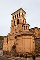
- The single-nave Iglesia de San Juan Bautista , built around 1480 instead of a Romanesque predecessor building, is dedicated to John the Baptist . The overall appearance of the rather late Gothic church is built exclusively from precisely hewn stone and has a Renaissance portal on the south side. The nave and apse are covered by star vaults. A Romanesque baptismal font has been preserved; In addition, you can still see several reused stones ( spoilage ) from the previous building.
- Another church (Iglesia de Nuestra Señora del Hortal) from the 16./17. Century is in the immediate vicinity. The design of the south facade with a late Gothic-looking keel arch portal and a transverse rectangular bell tower (campanar) , the upper floor of which shows Mudejar ornaments , is remarkable .
- The town hall (Casa Consistorial) is located in a three-storey Renaissance palace from the late 16th century, the facade of which is made of bricks in the Mudéjar style .
- A gate and watchtower integrated into the former city wall is also part of the townscape.
- In the center of the village, a stone bridge (puente) from the 17th or 18th century crosses the Río Manubles.
- Numerous rock cellars ( bodegas ) have been carved into the castle hill .

Iglesia de San Juan Bautista

Portal of the Iglesia de San Juan Bautista
South facade of the Iglesia de Nuestra Señora del Hortal

Portal of the Iglesia de Nuestra Señora del Hortal

Gate and watchtower


- Surroundings
- From the Ermita de Santa Bárbara you can enjoy a beautiful panoramic view of the place and the surrounding landscape.
Web links
Individual evidence
- ↑ Cifras oficiales de población resultantes de la revisión del Padrón municipal a 1 de enero . Population statistics from the Instituto Nacional de Estadística (population update).
- ↑ Torrijo de la Cañada - climate tables
- ↑ Torrijo de la Cañada - population development
- ↑ Torrijo de la Cañada - History
- ↑ Torrijo de la Cañada - castle ruins
- ↑ Torrijo de la Cañada - castle ruins
- ↑ Torrijo de la Cañada - castle ruins
- ↑ Torrijo de la Cañada - Church of San Juan
- ↑ Torrijo de la Cañada - Church of Nuestra Señora del Hortal
- ↑ Torrijo de la Cañada - Town Hall
- ↑ Torrijo de la Cañada - watchtower
- ↑ Torrijo de la Cañada - Bridge

Abanto | Acered | Agón | Aguarón | Aguilón | Ainzón | Aladrén | Alagón | Alarba | Alberite de San Juan | Albeta | Alborge | Alcalá de Ebro | Alcalá de Moncayo | Alconchel de Ariza | Aldehuela de Liestos | Alfajarín | Alfamén | Alforque | Alhama de Aragon | Almochuel | Almonacid de la Cuba | Almonacid de la Sierra | Alpartir | Ambel | Anento | Aniñón | Añón de Moncayo | Aranda de Moncayo | Arándiga | Ardisa | Ariza | Artieda | Asín | Atea | Ateca | Azuara | Badules | Bagüés | Balconchán | Bárboles | Bardallur | Belchite | Belmonte de Gracián | Berdejo | Berrueco | Biel | Bijuesca | Biota | Bisimbre | Boquiñeni | Bordalba | Borja | Botorrita | Brea de Aragon | Bubierca | Bujaraloz | Bulbuente | Bureta | Cabañas de Ebro | Cabolafuente | Cadrete | Calatayud | Calatorao | Calcena | Calmarza | Campillo de Aragón | Carenas | Cariñena | Caspe | Castejón de Alarba | Castejón de las Armas | Castejón de Valdejasa | Castiliscar | Cervera de la Cañada | Cerveruela | Cetina | Chiprana | Chodes | Cimballa | Cinco Olivas | Clarés de Ribota | Codo | Codos | Contamina | Cosuenda | Cuarte de Huerva | Cubel | Daroca | Ejea de los Caballeros | El Burgo de Ebro | El Buste | El Frago | El Frasno | Embid de Ariza | Encinacorba | Épila | Erla | Escatron | Fabara | Farlete | Fayón | Figueruelas | Fombuena | Fréscano | Fuendejalón | Fuendetodos | Fuentes de Ebro | Fuentes de Jiloca | Gallocanta | Gallur | Gelsa | Godojos | Gotor | Grisel | Grisén | Herrera de los Navarros | Ibdes | Illueca | Isuerre | Jaraba | Jarque | Jaulín | La Almolda | La Almunia de Doña Godina | La Joyosa | Lagata | La Muela | Langa del Castillo | La Puebla de Alfindén | Las Cuerlas | Las Pedrosas | La Vilueña | Layana | La Zaida | Lécera | Lechón | Leciñena | Letux | Litago | Lituénigo | Lobera de Onsella | Longares | Longás | Los Fayos | Los Pintanos | Lucena de Jalón | Luceni | Luesia | Luesma | Lumpiaque | Luna | Maella | Magallón | Mainar | Malanquilla | Maleján | Mallén | Malón | Maluenda | Manchones | Mara | María de Huerva | Marracos | Mediana de Aragon | Mequinenza | Mesones de Isuela | Mezalocha | Mianos | Miedes de Aragón | Monegrillo | Moneva | Monreal de Ariza | Monterde | Montón | Morata de Jalón | Morata de Jiloca | Morés | Moros | Moyuela | Mozota | Muel | Munébrega | Murero | Murillo de Gállego | Navardún | Nigüella | Nombrevilla | Nonaspe | Novallas | Novillas | Nuévalos | Nuez de Ebro | Olvés | Orcajo | Orera | Orés | Oseja | Osera de Ebro | Paniza | Paracuellos de Jiloca | Paracuellos de la Ribera | Pastriz | Pedrola | Perdiguera | Piedratajada | Pina de Ebro | Pinseque | Plasencia de Jalón | Pleitas | Plenas | Pomer | Pozuel de Ariza | Pozuelo de Aragón | Pradilla de Ebro | Puebla de Albortón | Puendeluna | Purujosa | Quinto | Remolinos | Retascón | Ricla | Romanos | Rueda de Jalón | Ruesca | Sabiñán | Sádaba | Salillas de Jalón | Salvatierra de Esca | Samper del Salt | San Martín de la Virgen de Moncayo | San Mateo de Gállego | Santa Cruz de Grío | Santa Cruz de Moncayo | Santa Eulalia de Gállego | Santed | Zaragoza | Sástago | Sediles | Sestrica | Sierra de Luna | Sigüés | Sisamón | Sobradiel | Sos del Rey Católico | Tabuenca | Talamantes | Tarazona | Thousand | Terrer | Tierga | Tobed | Torralba de los Frailes | Torralba de Ribota | Torralbilla | Torrehermosa | Torrelapaja | Torrellas | Torres de Berrellén | Torrijo de la Cañada | Tosos | Trasmoz | Trasobares | Uncastillo | Undués de Lerda | Urrea de Jalón | Urriés | Used | Utebo | Val de San Martín | Valdehorna | Valmadrid | Valpalmas | Valtorres | Velilla de Ebro | Velilla de Jiloca | Vera de Moncayo | Vierlas | Villadoz | Villafeliche | Villafranca de Ebro | Villalba de Perejil | Villalengua | Villamayor de Gállego | Villanueva de Gállego | Villanueva de Huerva | Villanueva de Jiloca | Villar de los Navarros | Villarreal de Huerva | Villarroya de la Sierra | Villarroya del Campo | Vistabella | Zuera