Ateca
| Ateca parish | ||
|---|---|---|
 Ateca - town view
|
||
| coat of arms | Map of Spain | |

|
|
|
| Basic data | ||
| Autonomous Community : | Aragon | |
| Province : | Zaragoza | |
| Comarca : | Comunidad de Calatayud | |
| Coordinates | 41 ° 20 ′ N , 1 ° 48 ′ W | |
| Height : | 590 msnm | |
| Area : | 84.70 km² | |
| Residents : | 1,762 (Jan 1, 2019) | |
| Population density : | 20.8 inhabitants / km² | |
| Postal code : | 50200 | |
| Municipality number ( INE ): | 50038 | |
| administration | ||
| Website : | Ateca | |
Ateca is a place and a central Spanish municipality ( municipio ) with 1,762 inhabitants (as of January 1, 2019) in the province of Zaragoza in the autonomous community of Aragón . The name of the place is sometimes derived from the Arabic عتيقة ( `Atīqa ), which means something like 'old' or 'ancient'; Another derivation takes the Latin place name Attacum, mentioned by Pliny , as its origin.
location
The municipality of Ateca is located at the confluence of the Río Manubles in the Río Jalón in the west of the province of Zaragoza not far from the border with the provinces of Soria and Guadalajara at an altitude of about 590 meters above sea level. d. M. The nearest town is Calatayud , about 15 km to the east ; the provincial capital of Saragossa is a good 100 km northeast. The climate in winter is cold, in summer temperate to warm; the little rain (approx. 390 mm / year) falls over the whole year.
Population development
| year | 1857 | 1900 | 1950 | 2000 | 2016 |
| Residents | 3,291 | 3.123 | 3,369 | 1,986 | 1,856 |
The mechanization of agriculture , the abandonment of small farms and the associated loss of jobs led to a noticeable decline in population in the second half of the 20th century.
economy
For centuries, Ateca was a medium-sized rural community near the intersection of several roads in central Spain. The residents lived mainly as a self-sufficient living from agriculture, with agriculture and cattle breeding being equally important. In addition, the importance of fruit cultivation ( apples , cherries , almonds , grapes, etc.), which is still of economic importance today, was recognized early on . A chocolate factory has existed in the village since the 19th century; there is also a small furniture factory.
history
Archaeological finds ( stone axes, etc.) have already been made from the Neolithic period . The proven history of the place goes back to the Celtiberian time (around 250 BC) when it was known under the name Alce . In the 2nd and 1st centuries BC Spain was conquered by the Romans , which resulted in an economic and cultural boom for large parts of the country. After late antiquity, the Visigoths invaded the Iberian Peninsula . From 711 onwards, the Arabs advanced with military support from various Berber tribes ; from 1018 to 1110 the area around Ateca belonged to the independent Taifa kingdom of Zaragoza. Although the city is said to have been briefly taken by El Cid in 1071 , it was not until 1120 that the date of the final reconquest ( reconquista ) by Alfonso I of Aragon was marked . The area around Ariza and Ateca was one of the most important theaters of war during the Guerra de los Dos Pedros (1356-1375); numerous castles (castillos) were destroyed during this time.
Attractions
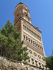
- Most significant attraction of Ateca is originally from the 13th century, but then repeatedly remodeled Parish Church (Iglesia de Santa María) , which at one almohadisches Brick - Minaret reminiscent tower basement in the finest Mudéjar with Fischgrätmustern , dentil bands , overlapping arcs and set Ziersäulchen is decorated. The upper floor of the tower was added in the 16th century; it ends in a pointed hood . As usual in the region, the interior of the church has only one nave; the polygonally broken apse contains an altarpiece from the middle of the 17th century.
- The Iglesia de San Francisco , built between 1627 and 1630, is sometimes called the Iglesia de San Martín . It belonged to a Franciscan convent that was disbanded in Spain in the 19th century .
- The clock tower (torre de reloj) is part of a fortress built in the 16th century.
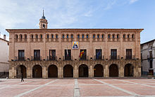
- Today's town hall (Ayuntamiento) is located in the former Casa Consistorial , a representative Renaissance building built between 1629 and 1634 .
- On the outskirts there are several hermit chapels (San Blas, San Gregorio, San Roque, Santiago, etc.)
- The bullring was built in the 1950s.
Personalities
- Antonio Duce Oliveros (1733–1788), architect of the city of Valdivia , Chile
Partner communities
- Lézat-sur-Lèze (France)
Web links
- Ateca in the Enciclopedia Aragonesa - photos + information (spanish)
- Iglesia de Santa María, exterior views - photos + information (Spanish)
- Iglesia de Santa María, stairs in the tower - photos + information (Spanish)
Individual evidence
- ↑ Cifras oficiales de población resultantes de la revisión del Padrón municipal a 1 de enero . Population statistics from the Instituto Nacional de Estadística (population update).
- ↑ Ateca - Map with altitude information
- ↑ Ateca - climate tables
- ↑ Ateca - population development
- ^ Ateca - Camino del Cid
- ↑ Ateca - history


