Orcajo
| Orcajo municipality | ||
|---|---|---|
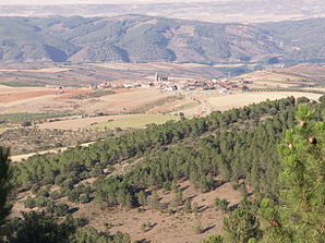
 View of the place
|
||
| coat of arms | Map of Spain | |

|
|
|
| Basic data | ||
| Autonomous Community : |
|
|
| Province : | Zaragoza | |
| Comarca : | Campo de Daroca | |
| Coordinates | 41 ° 7 ′ N , 1 ° 29 ′ W | |
| Height : | 770 msnm | |
| Area : | 28.45 km² | |
| Residents : | 58 (Jan. 1, 2019) | |
| Population density : | 2.04 inhabitants / km² | |
| Postal code : | 50366 | |
| Municipality number ( INE ): | 50195 | |
| administration | ||
| Mayor : | Pedro Luis Aparicio (PSOE-Aragon) | |
| Website : | orcajo.es.tl | |
Orcajo is a Spanish municipality in the Comarca of Campo de Daroca in the province of Saragossa in the autonomous region of Aragon . The place had 58 inhabitants (2019).
location
Orcajo is located at the foot of the Sierra de Santa Cruz about 85 km southwest of Saragossa and 250 km northeast of Madrid . To the Autovia Mudejar (A 23) in the east it is approx. 12 km and to the Autovia del Nordeste (A 2) in the north 25 km. Neighboring towns are in 5 km Daroca in the east, in 5 km Valdehorna in the southeast and Manchones and Murero in 5 km in the north.
history
The place was called Forcajo until 1543, after which it was called Horcajo and since 1646 as Orcajo. The population continued to decline in the 20th century. In 1910 there were still 500 inhabitants, in 1950 383 and in 1970 110 people lived in the village. In 1990 there were only 50 residents.
Web links
- Place website (Spanish)
Individual evidence
- ↑ Cifras oficiales de población resultantes de la revisión del Padrón municipal a 1 de enero . Population statistics from the Instituto Nacional de Estadística (population update).

