
Arnsburg (Seega)
| Arnsburg | ||
|---|---|---|
 Pointed arches of the east wing from the 14th century (2005) |
||
| Alternative name (s): | Arensburg | |
| Creation time : | First mentioned in 1116 | |
| Castle type : | Höhenburg, slope spur | |
| Conservation status: | ruin | |
| Standing position : | Ministerials | |
| Place: | Seega | |
| Geographical location | 51 ° 19 '12.5 " N , 11 ° 1' 34.5" E | |
| Height: | 293 m above sea level NN | |
|
||

The Arnsburg , also called Arensburg , is the ruin of a hilltop castle at 293 m above sea level. NN about 1.5 kilometers southwest of Seega in the Kyffhäuserkreis in Thuringia . It is located on a slope above the Wipper breakthrough valley . It is unclear whether the name of the castle is derived from Adlerburg .
history
The castle was first mentioned as an imperial castle in 1116 in the Pegau Annals in connection with the disputes between Heinrich V and the Saxon princes , when Heinrich von Meißen wanted to get to safety at the castle. It may have been destroyed for the first time in 1118 together with the nearby Kyffhausen Castle .
At an unknown point in time, the castle seems to have come into the possession of the Landgraves of Thuringia , as a ministerial Ulrich von Arnsburg is mentioned in 1229 . In the years 1278 and 1289, these ministerials were called burgraves .
At the end of the 13th century, the Counts of Hohnstein pushed into this area. In 1293 they are enfeoffed with the castle by Albrecht II . In 1356 the castle passed to the Counts of Schwarzburg . In 1433 they left the claim to the Arnsburg to the Counts of Stolberg in the event of their extinction. The Counts of Schwarzburg pledged the castle to the Lords of Vippach in 1498 . At this point it seems to have deteriorated considerably. It was finally destroyed in the Peasants' War in 1525 , but was still inhabited until 1547. The castle has not been mentioned since 1599.
The paper mill below the castle on the Wipper , first mentioned in a document in 1478, served as a grain and sawmill.
The Arnsburg office is named after the castle.
Building description
The 60 × 25 meter large castle complex is located on the southern slope of the Schlossberg on a foothills of the mountain facing south-southeast above the Wipper valley. Remains of various buildings still exist from the comparatively small complex.
To up to 353.7 m above sea level. NN high summit point rising attack side in the north of the castle site is a neck ditch and an additional ditch with a rampart as an approach obstacle. The remaining, steeply sloping sides were also secured by a ring trench with an outer wall. The highest point in the castle area was taken by a round keep , which stood in the north over the neck ditch. Only one stump of it that was buried today has survived, its diameter was about ten meters. This tower is one of the oldest buildings in the castle and is dated to the second half of the 12th century. The curtain wall also ran along between the keep and the neck ditch, the remains of which are still up to two meters high. The castle complex forms an inner courtyard surrounded by buildings in its center, but only a few remains of these buildings have survived. The most striking are the three (originally four) parallel to the circular wall, the ogival arcades of the east wing of the complex. Since these arcades are very similar to those of the palace of Straussberg Castle , they are attributed to the Counts of Schwarzburg, under whom they were built at the end of the 14th century. The south side of the castle complex forms the main residential building, which stands over a restored 6 × 13 meter barrel-vaulted cellar. This was accessible through an arched corridor from the courtyard, next to it another pointed arched entrance to a side cellar is visible, which is almost completely buried today. Access to the castle was possibly from the east at the level of the east wing. Outside this building, a remnant of a wall has been preserved on the outer wall of the ring moat, which could have served as a drawbridge abutment.
About 400 meters north-north-west of the Arnsburg there is another fortification at the summit of the Schlossberg, possibly the Altenburg , mentioned in 1505 . This fortification could have been the original site of the Arnsburg mentioned in 1116, which was rebuilt further south after it was destroyed. Another fortification is on the opposite bank of the Wipper, the Schwedenschanze on the Konstein. This is attributed to the late Bronze Age and the Iron Age , but could also have been committed in the Middle Ages.
Views

View of the Wippertal
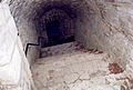
Reconstructed vault to the basement under the main residential building (2005)


literature
- Thomas Zunkel: Castles in Kyffhäuserland. Dingsda-Verlag, Querfurt 2004, ISBN 3-928498-93-2 , p. 101.
- Georg Dehio , edited by Stephanie Eißing, among others: Handbook of German Art Monuments. Thuringia. 2nd Edition. Deutscher Kunstverlag , Munich / Berlin 2003, ISBN 3-422-03095-6 , p. 1136.
- Michael Köhler: Thuringian castles and fortified prehistoric and early historical living spaces . 2nd expanded and revised edition. Jenzig-Verlag, Jena 2003, ISBN 3-910141-56-0 , p. 62.
- Thomas Bienert: Medieval castles in Thuringia - 430 castles, castle ruins and fortifications . 1st edition. Wartberg Verlag, Gudensberg-Gleichen 2000, ISBN 3-86134-631-1 , pp. 162-163.
- Hans Patze , Peter Aufgebauer (Ed.): Handbook of the historical sites of Germany . Volume 9: Thuringia (= Kröner's pocket edition . Volume 313). 2nd, improved and supplemented edition. Kröner, Stuttgart 1989, ISBN 3-520-31302-2 .
- The Kyffhäuser and its surroundings (= values of our homeland . Volume 29). 1st edition. Akademie Verlag, Berlin 1976, p. 179.
- Friedrich Stolberg: Fortifications in and on the Harz from early history to modern times - A manual . Verlagbuchhandlung August Lax, Hildesheim 1968, pp. 22–24.
Web links
Individual evidence
- ↑ Thomas Bienert: Medieval castles in Thuringia - 430 castles, castle ruins and castle sites , p. 162
- ↑ Source up to this point: Thomas Bienert: Medieval castles in Thuringia - 430 castles, castle ruins and castle sites , p. 162 f.
- ↑ Michael Köhler: Thuringian castles and fortified prehistoric and early historical living spaces , p. 180