
Atsubetsu-ku (Sapporo)
|
municipality of Sapporo |
|
|---|---|
 |
|
| Coordinates | 43 ° 2 '11 " N , 141 ° 28' 29" E |
| surface | 24.38 km² |
| Residents | 127,299 (Sep. 30, 2019) |
| Population density | 5221 inhabitants / km² |
| Start-up | Nov 6, 1989 |
| Community key | 01108-8 |
| Website |
www.city.sapporo.jp/ atsubetsu / |
Atsubetsu-ku ( Japanese. 厚 別 区 ) is one of ten boroughs ( ku ) of Sapporo , the capital of the Japanese prefecture of Hokkaidō . It is 24.38 km² and is therefore Sapporos smallest district in terms of area. In the west it borders on Shiroishi-ku , in the east on the city of Ebetsu , in the southeast on the city of Kitahiroshima and in the south on Kiyota-ku .
geography
Atsubetsu-ku lies in largely flat terrain on the edge of the Ishikari plain , only in the very south does the terrain rise slightly. In the east, the district has a small part of the Nopporo forest, which is protected as a nature park. The eponymous river Atsubetsu, which belongs to the catchment area of the Toyohira , forms almost the entire western district boundary. Significant tributaries are Nopporo and Sanri.
history
In 1883 the first settlers settled in the area. The road from Sapporo to Ebetsu was opened in 1889, followed by Atsubetsu station on the Hakodate main line in 1894 . From 1902, the area belonged to the Shiroishi municipality, which merged with the city of Sapporo in 1950. A munitions factory existed from 1943 to 1945 . Otherwise Atsubetsu was dominated by agriculture, with dairy farms predominating. This began to change in the 1950s with the realization of extensive housing projects.
From 1972, Ashibetsu belonged to the Toyohira-ku district . In the same year, the city government began to develop the area around the new Shin-Sapporo station on the Chitose Line into a sub-center with office buildings and shopping centers. In 1982 it was opened up by the subway. The population grew so rapidly that on November 6, 1989, the government created the new Atsubetsu-ku district from the eastern part of Toyohira-ku.
traffic
The main traffic axis is the national road 12 , which leads from Sapporo in the direction of Iwamizawa and Asahikawa . In the far southwest, the Hokkaidō highway to Muroran crosses the district area.
Two railway lines run through Atsubetsu-ku, the Hakodate main line with the stations Atsubetsu and Shinrinkōen and the Chitose line with the stations Shin-Sapporo and Kami-Nopporo. At the same time Shin-Sapporo is the eastern terminus of the Tōzai line of the Sapporo subway . Other subway stations are Hibarigaoka and Ōyachi. There are also several bus routes operated by private companies.
Attractions
- Atsubetsu Park and Stadium
- Historic Hokkaido Village (Open Air Museum)
- Hokkaidō Museum
- Nopporo Shinrin-kōen Natural Park
- Sapporo Science Center
- Sunpiazza Aquarium
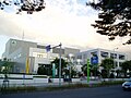
Atsubetsu-ku District City Hall
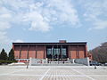
Hokkaidō Museum
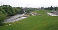
on the Atsubetsu River
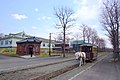
Horse-drawn tram in the open-air museum


_-_panoramio_(4).jpg)
education
Web links
- Atsubetsu-ku website (Japanese)
Individual evidence
- ↑ 区 の 紹 介. Atsubetsu-ku, May 23, 2017, accessed April 17, 2018 (Japanese).
- ↑ a b 厚 別 区 の 年表. Atsubetsu-ku, June 13, 2016, accessed April 17, 2018 (Japanese).
Atsubetsu-ku | Chūō-ku | Higashi-ku | Kita-ku | Kiyota-ku | Minami-ku | Nishi-ku | Shiroishi-ku | Teine-ku | Toyohira-ku