
Chūō-ku (Sapporo)
|
municipality of Sapporo |
|
|---|---|
 |
|
| Coordinates | 43 ° 3 '19 " N , 141 ° 20' 27" E |
| surface | 46.42 km² |
| Residents | 237,761 (Sep. 30, 2019) |
| Population density | 5122 inhabitants / km² |
| Start-up | Apr 1, 1972 |
| Community key | 01101-1 |
| Website |
www.city.sapporo.jp/ chuo / |
Chūō-ku ( Japanese. 中央 区 , dt. "Central District") is one of ten districts ( ku ) of Sapporo , the capital of the Japanese prefecture of Hokkaidō . It is 46.42 km² and includes the center of Sapporo and some adjacent areas. In the north it borders on Kita-ku , in the northeast on Higashi-ku , in the east on Shiroishi-ku , in the southeast on Toyohira-ku , in the south on Minami-ku and in the west on Nishi-ku .
geography
Chūō-ku extends 15.3 km in an east-west direction and 9.8 km in a north-south direction. It is the nucleus of Sapporo, which was founded as a planned city at the beginning of the Meiji period . Based on the American model, the road network has a checkerboard shape. It is not exactly aligned with the cardinal points and there are also isolated deviations. Ōdōri Park, which runs from west to east, is one block wide . Government institutions are concentrated to the north of the park, while densely built-up residential and business districts stretch to the south and west of it.
The Toyohira forms the entire eastern border of the district. The Sōsei Canal, which leads to the north, branches off from this river. The eastern third of the district lies in the extensive alluvial plain of the Toyohira. This is followed by sparsely populated, hilly terrain; distinctive elevations in this area are Maru-yama (225 m), Jinja-yama (237 m), Ōkura-yama (307 m) and the Moiwa-yama (531 m) panoramic mountain. The western third of the Kobayashi Pass and the foothills of Hyakumatsuzawa-yama (1010 m) and Toishi-yama (765 m) are mountainous, densely forested and largely uninhabited.
history
In 1857 the pioneers Shimura Tetsuichi and Yoshida Shigehachi settled on the banks of the Toyohira . 1866 instruct Tokugawa - shogunate the Samurai Ōtomo Kametarō with the construction of Sosei channel to agriculture to promote in the area. Shortly after the Meiji Restoration , the new imperial government decided to found a planned city on Toyohira, from which the island of Hokkaidō should be systematically colonized. Under the direction of Shima Yoshitake, a road network was created in a short time that laid the basis for future development. The city name comes from the nearby Ainu settlement Satsuporo (in today's Higashi-ku district ).
In 1879 Sapporo achieved local self-government as a district city ( machi ) within the district of Sapporo-gun , with the remaining communities being co-administered from here until 1884. In 1886 the first incorporations came about, through which the urban area roughly corresponded to today's district boundaries. On August 1, 1922, Sapporo received the status of an independent city ( shi ) by government resolution . Further incorporations followed in the years 1941 to 1967. On April 1, 1972, the government divided the city into districts (ku), with the city center since then belongs to Chūō-ku.
traffic
Chūō-ku is the starting point of several important road connections. These include Prefecture Road 124 (and then National Road 5 northwest to Otaru ), National Road 231 north to Rumoi , National Road 12 northeast to Iwamizawa , National Road 36 south-east to Muroran and National Road 230 south into the Toyohira Valley. The westernmost part of the district at Kobayashi Pass can only be reached by detouring via Prefecture Road 82.
The main train station Sapporo on the Hakodate Main Line is an important railway junction. From here, all major cities of Hokkaidō and New Chitose Airport can be reached by direct trains operated by JR Hokkaido . The Sasshō line branches off at Sōen station in the north of the district .
Three lines of the Sapporo subway intersect in the city center at the main train station and in Odori station: the Namboku line from north to south, the Tōzai line from west to east and the Tōhō line from northeast to southeast. The Sapporo tram connects the center with the neighboring districts to the south; the network consists of an 8.9 km long circuit. There are also numerous bus routes operated by private companies and a cable car to the Moiwa-yama.
Attractions
|

View from Moiwa-yama

Former government building

Ōdōri Park and TV Tower

Hokkaido shrine

Park on the Sosei Canal

Ōkurayama ski jump
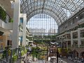
Sapporo Factory

JR Tower and Central Station

Sapporo clock tower

Nakajima Park

Hōheikan

Botanical Garden

Chūō-ku City Hall
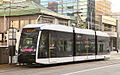
tram

Hokkaidō Museum of Modern Art

Municipal art museum

Kitara concert hall


.jpg)


Arts and Culture
education
- Hokkai Gakuen University
- Sapporo Medical University
- Hokkaidō College of Education
- Nayoro Municipal University (Sapporo Campus)
- Sapporo Municipal University
- University of Health Sciences
State institutions
Chūō-ku is the location of numerous state institutions. These include the administration and parliament of the Hokkaidō prefecture, the branch offices of various ministries and authorities, the Sapporo Supreme Court and other court instances. There are also the headquarters of the Prefecture Police and the Northern Army of the Self-Defense Forces .
Web links
- Chūō-ku website (Japanese)
Individual evidence
- ↑ a b 中央 区 の プ ロ フ ィ ー ル. Chūō-ku, April 12, 2016, accessed April 17, 2018 (Japanese).
- ↑ a b 中央 区 年表. Chūō-ku, April 12, 2018, accessed April 17, 2018 (Japanese).
- ↑ 角 川 日本 地名 大 辞典 北海道 編, Volume 1, pp. 1032-1033. Kadokawa Shoten, Chiyoda 1987.
Atsubetsu-ku | Chūō-ku | Higashi-ku | Kita-ku | Kiyota-ku | Minami-ku | Nishi-ku | Shiroishi-ku | Teine-ku | Toyohira-ku