Aurach (Ager)
| Aurach | ||
|
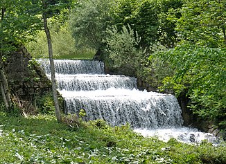
The Nadasdy-Klause on the Aurach above Neukirchen |
||
| Data | ||
| location | Upper Austria | |
| River system | Danube | |
| Drain over | Ager → Traun → Danube → Black Sea | |
| source | Aurach origin in the Hochlecken area of the Höllengebirge 47 ° 50 ′ 14 ″ N , 13 ° 37 ′ 5 ″ E |
|
| Source height | approx. 950 m above sea level A. | |
| muzzle | between Wankham and Sicking in the Ager coordinates: 48 ° 0 ′ 19 ″ N , 13 ° 44 ′ 15 ″ E 48 ° 0 ′ 19 ″ N , 13 ° 44 ′ 15 ″ E |
|
| Mouth height | approx. 400 m above sea level A. | |
| Height difference | approx. 550 m | |
| Bottom slope | approx. 20 ‰ | |
| length | 28 km | |
| Catchment area | 86 km² | |
| Discharge at the Aurachkirchen A Eo gauge : 81 km² Location: 4.2 km above the mouth |
NNQ (08/29/2003) MNQ 1976–2009 MQ 1976–2009 Mq 1976–2009 MHQ 1976–2009 HHQ (09/05/1987) |
8 l / s 290 l / s 2.2 m³ / s 27.2 l / (s km²) 52.9 m³ / s 162 m³ / s |
| Reservoirs flowed through | Taferlklaussee | |
| Communities | Altmünster , Pinsdorf , Ohlsdorf , Regau , Desselbrunn | |
The Aurach is a river in Upper Austria .
River course
The Aurach rises in the Hochlecken area of the Höllengebirge and flows through the wooded Aurach Valley, which runs through the municipal areas of Altmünster ( Neukirchen , Reindlmühl, Finsterau) and Pinsdorf (Kufhaus). It leaves the Aurach Valley near the village of Pinsdorf and continues through the Alpine foothills via Aurachkirchen until it flows into the Ager between Wankham and Sicking ( Desselbrunn municipality ) .
The Aurach is not to be confused with the Dürren Aurach , which flows almost parallel and flows into the Ager just a few kilometers upstream.
Tributaries
In the area of the municipality of Pinsdorf , the Aurach is fed by several small tributaries:
- Wolfsbach
- Viehbach
- Steinbach
- Luderbach
- Groissbach
In the area of the municipality of Altmünster , the cadastral municipality of Reindlmühl, the Aurach is fed by:
- Dambach
- Dauerbach
- Wessenaurach
- Haunstielbach
- Klingbach
ecology
In the uppermost section, the Aurach runs in the forest, otherwise through grassland used and populated area. It is hard-built in the settlement area. Outside of the settlements there is a wood accompanying the river bank over long stretches, but it is usually very narrow. It consists primarily of ash , willow , black alder , sycamore maple , elder , mountain and white elm and common hazel . At Ritzing, the wooded edge of the bank merges into a larger alluvial forest area .
The Aurach has water quality classes I to II throughout its course .
Surname
The Aurach is first mentioned in 1130 as de Urahe . The name is made up of ahd. Aha (ache) and ûr (o) (aurochs), which means something like "brook where aurochs graze".
literature
- Markus Purkhart: Pinsdorf. The history. A place in the Salzkammergut. Pinsdorf 2000.
Individual evidence
- ↑ a b c Digital Upper Austrian Room Information System (DORIS)
- ↑ Reinhard Wimmer: Flow order numbers, water system analysis and flow regime of the Traun . In: The Traun - river without return, catalog of the Upper Austria. Landesmuseums, 1992, Volume 2, p. 37 ( PDF )
- ↑ Federal Ministry for Agriculture, Forestry, Environment and Water Management (ed.): Hydrographisches Jahrbuch von Österreich 2009. 117th volume. Vienna 2011, PDF (12.1 MB) on bmlrt.gv.at (yearbook 2009)
- ^ Office of Upper Austria. Provincial government (ed.): Natural area mapping Upper Austria - landscape survey of the Altmünster community. Final report. Kirchdorf an der Krems 2009 ( PDF; 5.4 MB )
- ^ Office of Upper Austria. Provincial government (Hrsg.): Natural area mapping Upper Austria - Landscape survey of the community of Pinsdorf. Final report. Kirchdorf an der Krems 2009, PDF (1.6 MB) on ZOBODAT
- ^ Office of Upper Austria. Provincial government, nature conservation department (ed.): Nature and landscape - models for Upper Austria. Volume 22: Room Unit Vöckla-Ager-Hügelland , revised. Version, Linz and Vienna 2007 (PDF; 878 kB)
- ^ Office of Upper Austria. State government: water quality maps
- ^ Peter Wiesinger: Place names and settlement history in the Salzkammergut. In: Yearbook of the Upper Austrian Museum Association. Volume 149/1, Linz 2004, pp. 543-560, PDF (2.3 MB) on ZOBODAT
