Avicaya
| Avicaya | ||
|---|---|---|
| Basic data | ||
| Residents (state) | 616 pop. (2012 census) | |
| height | 3843 m | |
| Post Code | 04-0602-0400-1001 | |
| Telephone code | (+591) | |
| Coordinates | 18 ° 32 ′ S , 66 ° 53 ′ W | |
|
|
||
| politics | ||
| Department | Oruro | |
| province | Poopó Province | |
| climate | ||
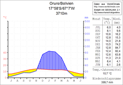
 Oruro climate diagram |
||
Avicaya is a town in the Oruro department in the highlands of the South American Andean state of Bolivia .
Location in the vicinity
Avicaya is the central place of the canton Avicaya in the municipality Pazña in the province Poopó . The village is situated at an altitude of 3843 m on the middle reaches of the River Antequera that the later in the eastern part Poopó Lake opens an approximately 1300 sq km large salt lake south of the city of Oruro .
geography
Avicaya is located on the Bolivian Altiplano on the western edge of the Cordillera Azanaques , a section of the Cordillera Central .
The mean annual temperature of the region is around 10 ° C (see climate diagram Oruro), the annual precipitation is 400 mm. The region has a distinct daytime climate, the monthly average temperatures fluctuate only slightly between 6 ° C in July and a good 13 ° C from November to December. The monthly precipitation is less than 10 mm in the months May to August and only falls from December to March in a significant amount of 60 to 85 mm.
traffic
Avicaya is 90 kilometers by road from Oruro, the capital of the department of the same name.
From Desaguadero on Lake Titicaca , the asphalted national road Ruta 1 crosses the highlands of Bolivia in a north-south direction. It leads via El Alto and Oruro to Pazña and from there on in a southerly direction via Potosí and Tarija to Bermejo on the Bolivian- Argentine border.
In Pazña, a dirt road branches off in a north-easterly direction into the Antequera Valley and leads via Avicaya to the villages of Totoral , Campamento Bolívar and Antequera .
population
The population of the village has increased by almost a quarter in the past two decades:
| year | Residents | source |
|---|---|---|
| 1992 | 508 | census |
| 2001 | 289 | census |
| 2012 | 616 | census |
Due to the historical population distribution, the region has a high proportion of Quechua population, in the Municipio Pazña 66.5 percent of the population speak Quechua .
Cañadón Peñas
Cañadón Peñas ( cañadón = field in the valley that is flooded when it rains; peña = rock, mountain ) is the name for a development project in the canton of Peñas that has been supported by German World Hunger Aid since around 2005 as one of fifteen " Millennium Villages " . In joint workshops, the impoverished inhabitants of the Peñas Valley, together with experts from Welthungerhilfe, have drawn up a five-year plan, the improvements of which are to be implemented in four areas: nutrition, the economy, education, and a say for women. These goals are to be achieved through improvements in animal husbandry, the establishment of small cheese factories and the establishment of schools with lunch. With this project, Welthungerhilfe is not only supporting the 400 families in the Peñas Valley, but also the 13,000 rural residents of the Pazña and Antequera region, whose schools are involved in the project.
Individual evidence
- ^ INE - Instituto Nacional de Estadística Bolivia 1992 ( Memento from April 23, 2014 in the Internet Archive )
- ^ INE - Instituto Nacional de Estadística Bolivia 2001 ( Memento of February 23, 2014 in the Internet Archive )
- ^ INE - Instituto Nacional de Estadística Bolivia 2012 ( Memento of July 22, 2011 in the Internet Archive )
- ↑ INE social data Oruro 2001 ( Memento from March 4, 2016 in the Internet Archive ) (PDF; 6.2 MB)
- ↑ Welthungerhilfe ( Memento from January 9, 2011 in the Internet Archive )
Web links
- Raised relief map Region Uncia 1: 250,000 (JPEG; 8.22 MB)
- Municipio Pazña - detailed map and population data (PDF; 331 kB) ( Spanish )
- Departamento Oruro - Social data of the municipalities (PDF; 5.86 MB) ( Spanish )
