Antequera
| Antequera municipality | ||
|---|---|---|
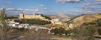
 Antequera - town view
|
||
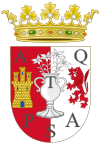
| coat of arms | Map of Spain | |
|
|
|
| Basic data | ||
| Autonomous Community : |
|
|
| Province : | Málaga | |
| Comarca : | Antequera | |
| Coordinates | 37 ° 1 ′ N , 4 ° 34 ′ W | |
| Height : | 515 msnm | |
| Area : | 749.34 km² | |
| Residents : | 41,239 (Jan. 1, 2019) | |
| Population density : | 55.03 inhabitants / km² | |
| Postal code : | 29200 | |
| Municipality number ( INE ): | 29015 | |
| administration | ||
| Website : | Antequera | |
Antequera is a city and a municipality with 41,239 inhabitants (as of January 1, 2019) in the Andalusian province of Málaga ( Spain ). The city has been nicknamed "Heart of Andalusia" since the 16th century because of its importance for the country's culture and history and its geographical location on the connecting routes between the major Andalusian cities of Málaga , Granada , Córdoba and Seville . The entire old town was recognized as a conjunto histórico-artístico in 2013 .
location
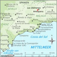
Antequera is a good 50 kilometers (driving distance) north of the provincial capital Málaga and the Costa del Sol on the edge of the mountain ranges ( Spanish : Sierras ) El Torcal and El Arco Calizo Chimenea at an altitude of approx. 515 msnm . The Guadalhorce River and its numerous stream tributaries (arroyos) contribute to the fertility of the surrounding land. The climate in winter is more moderate, in summer it is warm to hot; the annual rainfall (approx. 620 mm / year) falls - with the exception of the almost rainless summer months - distributed over the whole year.
Population development
| year | 1857 | 1900 | 1950 | 2000 | 2016 |
| Residents | 27,340 | 31,609 | 43,334 | 40,596 | 41,065 |
The significant increase in population since the end of the 19th century is mainly due to immigration from the rural areas in the surrounding area.
economy
Traditionally, agricultural products ( olives , grain , sheep's wool ) as well as their processing into ( olive oil or textiles ) and handicrafts (pottery, carpentry) were the determining branches of the economy in the region. Today tourism is the dominant economic factor.
History and culture
Prehistory and early history
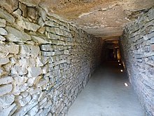
On the northeastern outskirts of the city are the Dolmen de Menga and the Dolmen de Viera from around 3800 BC. BC, which are among the largest megalithic systems in Europe. The larger one, Menga, has a diameter of 25 meters, is 4 meters high and made up of 32 megaliths, the heaviest of which weighs around 180 t . After completion of the chamber and the corridor, the facility was covered with earth. The hill has been preserved to this day. In the 19th century, archaeologists found the skeletons of several hundred people in the chamber.
Just outside the city is the Tholos de El Romeral from around 1800 BC. BC, in whose construction smaller stone formats were also used.
The Dolmen Viera, Menga and El Romeral were named UNESCO World Heritage Sites after successful application in 2016, as well as the El Torcal Mountains surrounding Antequera and La Peña de los enamorados , a mountain in the shape of a reclining Indian head.
From the 7th century BC Iberians settled the region, whose cultural and economic contacts with the Phoenicians and Greeks are documented by numerous archaeological finds. Around the middle of the 1st millennium BC The Iberians sometimes mixed with the immigrating Celts (see also Celtiberians ) and formed the Turdetan people in southern Spain, today's Andalusia (see also: Tartessos ).
Roman Empire
In the last third of the 1st millennium BC The Iberian Peninsula became part of the Roman Empire . The Turdetans soon adopted the culture and language of the Romans and the transition to Roman rule was largely peaceful. As with many other places in Andalusia, the city map still visible today and the name Anticaria go back to that time. As in the times of the Iberians and Turdetans, the city was an important trading center under Roman rule, especially known for the quality of the olive oil produced here . In the southeast of the city, the excavations of the Roman baths can be visited today.
From the middle of the 1st millennium onwards, the Romans were increasingly displaced by peoples such as the Vandals , Alans and Suebi who immigrated via the Pyrenees . For a short time the Eastern Roman Byzantines took power; but these in turn were defeated by the Visigoths .
Al-Andalus
In 711, the conquest of the Iberian Peninsula began by those from North Africa originating Muslim Moors . From around 716 the former Anticaria was also a Moorish city, shaped by its culture, tradition and architecture, and received a new name: Medina Antaquira .
The decline of the Moorish Al-Andalus began with the battle of Las Navas de Tolosa (1212), in which the Almohads ruling at the time were subject to the united armies of the Christian kingdoms in the north of the peninsula . Medina Antaquira, then inhabited by about 2,600 people, became - as one of the northernmost cities of the remaining kingdom of the Nasrid races of Granada - an important border town. To defend against the troops of the Catholic kingdoms in the north, the fortifications were expanded and a castle was built on the hill overlooking the city, the Alcazaba (cf. Kasbah ). Only a few parts of the fortification walls and a few towers of this fortress can be seen today - including the Torre del Homenaje, which was later expanded and rebuilt by the Spanish .
For around two hundred years, Medina Antaquira was repeatedly exposed to attacks by Christian kings (see also Reconquista ). It was not until September 16, 1410 that an army led by Ferdinand I of Aragón ("Infante Don Fernando") was able to conquer the city. This victory gave the ruler, who was raised to King of Aragon in 1412 , the nickname "Ferdinand of Antequera" (Don Fernando de Antequera). The main street in Antequera still bears his name: Calle Infante Don Fernando . After the battle of 1212, the conquest of Antequera is considered the second decisive victory for the Christians in their endeavors to oust the Moors from Spain.
Spain
After Antequera became part of the Kingdom of Castile , the Muslim population was partly murdered and partly expelled. The city was now a frontier and fortress city of the Catholics against the Nasrid Empire of Granada and the starting point of a number of conquests. It was only after Granada surrendered in 1492 as the last Moorish city of the former Al-Andalus that the city began to recover from centuries of struggle and began to attract people again who settled permanently.
Antequera became an important commercial city at the crossroads of the routes between Málaga in the south, Granada in the east, Cordoba in the north and Seville in the west. This position, together with the flourishing agriculture, the artisans known for their work and the cultural achievements of the city, contributed to Antequera being nicknamed "Heart of Andalusia" from the 16th century. During this time, the cityscape also changed fundamentally. Mosques and houses were torn down and new buildings, often churches, erected in their place. The oldest church in Antequera, the late Gothic Iglesia San Francisco, was built around 1500.
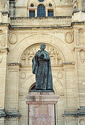
In 1504 “La Colegial” was founded, a humanistic chair for grammar, where a number of writers and scholars of great importance for the Spanish Renaissance came together. In the course of the 16th century, the School of the Poets of Antequera, which among others belonged to Pedro Espinosa , Luis Martín de la Plaza and Cristobalina Fernández de Alarcón , and the School of Plastic Arts, whose artists found employment mainly in the numerous church buildings, also emerged and whose works were also in demand in the surrounding regions around Seville, Málaga and Córdoba. Among the newly built churches were the collegiate church of San Sebastián in the city center and the largest and most magnificent in the city, Real Colegiata de Santa María la Mayor (1514–1550) with its austere facade, which combines Renaissance and late Gothic elements.
A large number of other church buildings were built into the 18th century (today there are a total of 32 in the city) and also palaces for the members of the nobility and the wealthier citizens in the style of the Spanish Baroque .
The cultural heyday of Antequera gradually came to an end at the end of the 17th and the beginning of the 18th centuries. Spain suffered the loss of its American colonies and also lost a number of decisive armed conflicts in Europe. This was accompanied by a profound economic crisis, which in some regions of the country even led to people switching back to bartering. The church, the nobility and the bourgeoisie - the big landowners - previously the clients and patrons of the artists, lost the majority of their assets and could not pay for further church buildings or palaces.
From the middle of the 18th century, Spain experienced a slow economic boom through a series of reforms - in particular a land reform and the suppression of the power of the Roman Catholic Church (expulsion of the Jesuits in 1767). For Antequera, textile production in particular became the main industry. In 1804, the city's upswing was interrupted by a yellow fever epidemic and the Napoleonic Wars that followed shortly afterwards . The textile industry in Antequera experienced another serious crisis in the early 20th century. It was not until the 1960s, when the nearby Costa del Sol developed into an international tourist destination , that Antequera experienced an economic boom again. Today the city is both a tourist and a cultural center of national importance.
Attractions

Antequera is primarily regional, but increasingly also international, a destination for travelers interested in culture; The city's museums contain a large part of all the art treasures of the province of Malaga, which makes it one of the most culturally important centers in Andalusia.
- The originally Roman, then Moorish, but later redesigned by the Christians fortress (alcazaba) with its keep (torre del homenaje) rises on a hill in the southeast of the city .
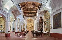
- The three-portal Real Colegiata de Santa María la Mayor , approved by a bull from Pope Julius II on the initiative of the Catholic Kings Isabella I and Ferdinand II, is the largest and historically most important church building in the city; it was built between 1514 and 1550 on the eastern slope of the castle hill. The unfinished facade on the right shows clear Renaissance forms with a few reminiscences of the Gothic . The interior of the church, with three aisles and artesonado roof trusses, is separated from one another by antique columns (not pillars ); the elongated apse has rib vaults . The south side is stabilized by additional chapels.
- Another collegiate church ( Real Colegiata de San Sebastián ) was built in the center of the city in the 1940s. While the facade of the three-nave church shows clear Renaissance forms in was Mudejar tradition entirely of bricks brick bell tower built only in the years 1701 to 1706 and shows a clear baroque design. The spire with an angel figure turning in the wind (El Angelote) was renewed after a fire in 1926.
- Several convents are spread across the city: Convento de Madre de Dios de Monteagudo (around 1750, Augustinian women ), Convento de Belén (around 1630, Discalced Carmelites , Poor Clares since the 19th century ), Convento de la Victoria (around 1715, Paulaner ) , Convento de la Encarnación (around 1560, Carmelites in Shoed), Convento de San Agustín (around 1560, Augustinian ), Convento de la Trinidad (around 1560, Trinitarians ), Convento de los Remedios (around 1630, Third Order of the Franciscans), Convento de Santo Domingo (around 1720, Dominican ), Convento de San José (around 1630–1734, Discalced Carmelite Sisters), Convento de las Catalinas (around 1735, Dominican Sisters ), Real Monasterio de San Zoilo (16th / 17th century, Franciscan ), Convento de la Magdalena (around 1580 hermits , around 1680 Franciscans, today a hotel)
- The town's churches, chapels, mansions (palacios) and fountains are just as numerous .
- Museums
- The Museo de la Ciudad de Antequera was founded as an archaeological museum at the beginning of the 20th century. It houses numerous finds from Roman and Moorish times, but medieval and early modern exhibits can also be seen.
- The Museo Conventual de las Descalzas houses numerous exhibits on Christian art .
- The Museo de Usos y Costumbres in the former church of San Benito deals with the folk customs of the city and the surrounding area.
- The Museo del Aceite presents exhibits and information boards on the history of olive oil production in the region.
Town twinning
Antequera has twinned cities with
sons and daughters of the town
- Pedro Espinosa (1578–1650), humanistic writer and poet during the Spanish Baroque period
- Kiti Manver (* 1953 as María Isabel Ana Mantecón Vernalte ), Spanish actress
- Juan Calatayud Sánchez (* 1979), football player
literature
- Jesús Romero Benítez: Guía Artística de Antequera. Antequera 1989, ISBN 84-505-8551-1 .
- Jesús Romero Benítez: Antequera, ciudad monumental. Antequera 2012, ISBN 978-84-616-2182-8 .
Web links
- statistical data ( Memento of April 25, 2003 in the Internet Archive ) (Spanish)
- Antequera, Dolmen de Menga - sectional drawings, photos + information (Spanish)
- Antequera, Dolmen El Romeral - sectional drawings, photos + information (Spanish)
- Antequera, buildings - photos + information
- Antequera, sights - photos + information (Spanish)
Individual evidence
- ↑ Cifras oficiales de población resultantes de la revisión del Padrón municipal a 1 de enero . Population statistics from the Instituto Nacional de Estadística (population update).
- ^ Antequera map with altitude information
- ↑ Antequera - climate tables
- ^ Antequera - population development
- ↑ Antequera - Real Colegiata de Santa María la Mayor ( Memento of the original from September 7, 2017 in the Internet Archive ) Info: The archive link was inserted automatically and has not yet been checked. Please check the original and archive link according to the instructions and then remove this notice.
- ^ Antequera - Museo de la Ciudad
- ^ Antequera - Museo Conventual de las Descalzas
- ^ Antequera - Museo de Usos y Costumbres San Benito
- ^ Antequera - Museo del Aceite

