
Torrox
| Torrox | |||
|---|---|---|---|
| coat of arms | Map of Spain | ||

|
|
||
| Basic data | |||
| Autonomous Community : | Andalusia | ||
| Province : | Málaga | ||
| Coordinates | 36 ° 46 ′ N , 3 ° 57 ′ W | ||
| Height : | 120 msnm | ||
| Area : | 51 km² | ||
| Residents : | 17,234 (Jan 1, 2019) | ||
| Population density : | 337.92 inhabitants / km² | ||
| Postal code : | 29770 (Torrox pueblo), 29793 (Torrox-Costa) | ||
| Municipality number ( INE ): | 29091 | ||
| administration | |||
| Mayor : | Óscar Medina ( PP ) | ||
| Website : | www.torrox.es | ||
| Location of the city | |||

|
|||

Torrox is a small town in the province of Málaga in Andalusia ( Spain ), about 50 km east of Málaga . The city consists of the districts Torrox-Pueblo in the Axarquia , the eastern part of the Costa del Sol , and Torrox-Costa .
development
Due to heavy building activity, the two districts are growing closer and closer together.
Torrox-Pueblo, the core town, which is about four kilometers from the coast, is a typical Andalusian village, with narrow, winding streets and whitewashed houses and a Moorish past, which can still be recognized today by the old city wall and the fortification towers .
Torrox-Costa, on the other hand, was once a Roman manufacturing and trading town, whose past is evidence of the old ruins of thermal baths, a luxurious villa and a necropolis . Today you can find the longest beach promenade on the Costa del Sol with numerous tourist facilities.
traffic
Torrox Pueblo is on the A-7 autovía ; Torrox-Costa can also be accessed via the N-340 coastal road.
Attractions
On the east side of Torrox-Costa is a fully automatic lighthouse ( Faro de Torrox ), which was completed on May 1st, 1864 and is 26 m high (39 m above sea level).
Town twinning
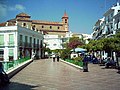
Plaza de la Constitucion, Torrox Pueblo
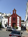
The Oldest Church In Torrox, Torrox Pueblo

Faro de Torrox


Web links
Individual evidence
- ↑ Cifras oficiales de población resultantes de la revisión del Padrón municipal a 1 de enero . Population statistics from the Instituto Nacional de Estadística (population update).
Alameda | Alcaucín | Alfarnate | Alfarnatejo | Algarrobo | Algatocín | Alhaurin de la Torre | Alhaurín el Grande | Almáchar | Almargen | Almogía | Álora | Alozaina | Alpandeire | Antequera | Árchez | Archidona | Ardales | Arenas | Arriate | Atajate | Benadalid | Benahavís | Benalauría | Benalmádena | Benamargosa | Benamocarra | Benaoján | Benarrabá | Campillos | Canillas de Aceituno | Canillas de Albaida | Cañete la Real | Carratraca | Cartajima | Cartama | Casabermeja | Casarabonela | Casares | Coín | Colmenar | Comares | Cómpeta | Cortes de la Frontera | Cuevas Bajas | Cuevas de San Marcos | Cuevas del Becerro | Cútar | El Borge | El Burgo | Estepona | Faraján | Frigiliana | Fuengirola | Fuente de Piedra | Gaucín | Genalguacil | Guaro | Humilladero | Igualeja | Istán | Iznate | Jimena de Líbar | Jubrique | Júzcar | Macharaviaya | Málaga | Manilva | Marbella | Mijas | Moclinejo | Mollina | Monda | Montejaque | Nerja | Ojén | Parauta | Periana | Pizarra | Pujerra | Rincon de la Victoria | Riogordo | Ronda | Salares | Sayalonga | Sedella | Sierra de Yeguas | Teba | Tolox | Torremolinos | Torrox | Totalán | Valle de Abdalajís | Vélez-Málaga | Villanueva de Algaidas | Villanueva de la Concepción | Villanueva de Tapia | Villanueva del Rosario | Villanueva del Trabuco | Viñuela | Yunquera