
Frigiliana
| Frigiliana municipality | |||
|---|---|---|---|
| coat of arms | Map of Spain | ||

|
|
||
| Basic data | |||
| Autonomous Community : | Andalusia | ||
| Province : | Málaga | ||
| Comarca : | Axarquía - Costa del Sol | ||
| Coordinates | 36 ° 48 ′ N , 3 ° 54 ′ W | ||
| Height : | 320 msnm | ||
| Area : | 39.74 km² | ||
| Residents : | 3,009 (Jan 1, 2019) | ||
| Population density : | 75.72 inhabitants / km² | ||
| Postal code : | 29788 | ||
| Municipality number ( INE ): | 29053 | ||
| Nearest airport : | Málaga ( Aeropuerto de Málaga , 59 km ) | ||
| administration | |||
| Official language : | Castilian | ||
| Mayor : | Javier López Ruiz ( PA ) | ||
| Website : | www.frigiliana.es | ||
| Location of the municipality | |||
Málaga Province
|
|||

The white mountain village of Frigiliana is located in Andalusia in the Axarquía district of the province of Málaga in Spain . The village is about 65 km east of Málaga and about 7 kilometers from Nerja and has 3009 inhabitants (as of January 1, 2019).
Frigiliana, which is over 435 m above sea level, is one of the places in the province of Málaga where the original Moorish structure of the old town center is best preserved. Here you can still find the typical narrow streets and white houses decorated with flowers and ornaments, for which the region is known. According to local law, residents are obliged to regularly whitewash their houses. Frigiliana has received the “Most Beautiful Village in Andalusia” award several times.
The place is nestled on the southern slopes of the Sierra de Enmedio, which form part of the Sierra de Almijara Mountains, the border line between the provinces of Málaga and Granada. From many places in town you have a view down to the Mediterranean Sea.
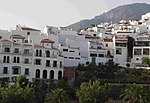
White village of Frigiliana
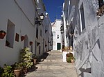
Alley in Frigiliana
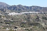
View of Frigiliana


Web links
- Official website of the Frigiliana Tourist Office
- A stroll through Frigiliana
- Statistical information on Frigiliana
Individual evidence
- ↑ Cifras oficiales de población resultantes de la revisión del Padrón municipal a 1 de enero . Population statistics from the Instituto Nacional de Estadística (population update).
Alameda | Alcaucín | Alfarnate | Alfarnatejo | Algarrobo | Algatocín | Alhaurin de la Torre | Alhaurín el Grande | Almáchar | Almargen | Almogía | Álora | Alozaina | Alpandeire | Antequera | Árchez | Archidona | Ardales | Arenas | Arriate | Atajate | Benadalid | Benahavís | Benalauría | Benalmádena | Benamargosa | Benamocarra | Benaoján | Benarrabá | Campillos | Canillas de Aceituno | Canillas de Albaida | Cañete la Real | Carratraca | Cartajima | Cartama | Casabermeja | Casarabonela | Casares | Coín | Colmenar | Comares | Cómpeta | Cortes de la Frontera | Cuevas Bajas | Cuevas de San Marcos | Cuevas del Becerro | Cútar | El Borge | El Burgo | Estepona | Faraján | Frigiliana | Fuengirola | Fuente de Piedra | Gaucín | Genalguacil | Guaro | Humilladero | Igualeja | Istán | Iznate | Jimena de Líbar | Jubrique | Júzcar | Macharaviaya | Málaga | Manilva | Marbella | Mijas | Moclinejo | Mollina | Monda | Montejaque | Nerja | Ojén | Parauta | Periana | Pizarra | Pujerra | Rincon de la Victoria | Riogordo | Ronda | Salares | Sayalonga | Sedella | Sierra de Yeguas | Teba | Tolox | Torremolinos | Torrox | Totalán | Valle de Abdalajís | Vélez-Málaga | Villanueva de Algaidas | Villanueva de la Concepción | Villanueva de Tapia | Villanueva del Rosario | Villanueva del Trabuco | Viñuela | Yunquera