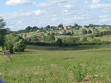
Błotnia (Trąbki Wielkie)
| Błotnia | ||
|---|---|---|

|
|
|
| Basic data | ||
| State : | Poland | |
| Voivodeship : | Pomerania | |
| Powiat : | Gdański | |
| Gmina : | Trąbki Wielkie | |
| Geographic location : | 54 ° 11 ′ N , 18 ° 24 ′ E | |
| Residents : | 181 (December 31, 2010) | |
| Postal code : | 83-041 | |
| Telephone code : | (+48) 58 | |
| Economy and Transport | ||
| Street : | Ext. 226 Przejazdowo - Horniki Dolne | |
| Next international airport : | Danzig | |
Błotnia [ˈbwɔtɲa] (German Braunsdorf ) is a village within the rural community Trąbki Wielkie ( Groß Trampken ) in the powiat Gdański ( district of Danzig ), Pomeranian Voivodeship , in northern Poland .
It is located on Provincial Road 226, about 10 km west of Trąbki Wielkie , 19 km southwest of Pruszcz Gdański ( Praust ) and 27 km southwest of Gdansk .
The village had 181 inhabitants on December 31, 2010.
history
Błotnia was called Braunsdorf and from 1818 belonged to the district of Danzig and came with it to Germany in 1871 . With the dissolution of the district, Braunsdorf became part of the new district of Danziger Höhe in 1887, and with this, from 1920 to 1939, it became part of the Danzig mandate of the League of Nations. In 1939, in an act not recognized by international law , the Third Reich annexed the mandate area and incorporated it into the occupying Danzig-West Prussia , to which Braunsdorf belonged until the end of the Second World War .
Footnotes
- ↑ a b Główny Urząd Statystyczny, Portret miejscowości statystycznych w gminie Trąbki Wielkie (powiat gdański, województwo pomorskie) w 2010 r. Online query
- ^ The Genealogical Place Directory gov.genealogy.net
- ↑ West Prussian local directory www.westpreussen.de

