Bad Einsiedel
|
Bad Einsiedel
Municipality of Seiffen / Erzgeb.
Coordinates: 50 ° 38 ′ 48 ″ N , 13 ° 29 ′ 9 ″ E
|
||
|---|---|---|
| Postal code : | 09548 | |
| Area code : | 037362 | |
|
Location of Bad Einsiedel in Saxony |
||
Bad Einsiedel is a small one belonging to the Saxon community of Kurort Seiffen / Erzgeb. proper settlement.
geography
Bad Einsiedel is about 2.5 kilometers east of Seiffen in the Ore Mountains . The settlement is completely surrounded by the so-called Einsiedler Forest .
A municipal road connects to the Seiffen district of Heidelberg and the crossing state road 207 Eppendorf - Deutscheinsiedel , which here follows the course of a historic Erzgebirge pass. The summit of the Deutscheinsiedler saddle at 720 m above sea level. NN is about 600 meters south of Bad Einsiedel.
history
Cistercian monastery courtyard
The place was first settled around 1209 as part of the colonization of the ridge region of the Ore Mountains by Cistercians from the Ossegg monastery .
The decisive factor for this was the first mountain screaming in the Freiberg area , which was followed by the seizure of land for the respective domain and thus the safeguarding of the natural resources there.
The only viable connection to this region at the time was a route via Dux, Brüx and from there following a Bohemian path northwards into the region around the present-day towns of Böhmisch-Einsiedel and Deutscheinsiedel. In a file from 1560 in the Main State Archives in Dresden , this area is described as follows:
"With, [...] the brothers - Do ethero a Clauss and Capelle confessed, Ford Arnsbergk up to the Einsiedel, a village called, Which kegen Brüx belongs, And a house with several fields and meadows [...], then up to Dreier Mr. Reinung [...] "
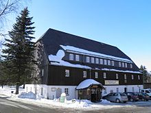
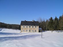
This proves, among other things, that the name Brüderwiese , where a central starting point for the settlement of the mountain ridge originated, does not come from exiles who settled there in the late 17th century, but rather goes back to the presence of Cistercians in this area. The aforementioned “house with a number of fields and meadows” can only be the area of Bad Einsiedel. The current buildings were constructed between 1723 and 1753. The dimensions of these three buildings correspond to those of an archaeologically investigated monastery courtyard ( grangie ) of the Ossegg monastery elsewhere. It can be assumed that today's buildings were built on the foundations of the earlier grangie. The size of the complex suggests an important monastery courtyard. On a map from 1694, which is also in the HStA in Dresden, the area in question is referred to as "Des Meister Heyde". Heyde stands for cleared land, the Cistercian converses who were entrusted with the management of a monastery courtyard, for example , were called masters or masters .
Medicinal springs and spa
The four sources of iron and silicic acid in the Frauenbach were verifiably discovered around 1550 and soon afterwards described in a paper by Leonhard Thurneysser .
But water also had a symbolic meaning for the Cistercians. They probably knew about the healing properties of the spring water and possibly used it. The sources could also have been decisive for the creation of a grangie at this location.
Thurneysser attributed a healing effect on ulcers , melancholy and open wounds to the sources . Continuous use of the springs probably did not take place until the 18th century, as the first bathhouse with bathing rooms was not built until 1723. The von Schönberg family, who lived at Purschenstein Castle , had a main house built in 1753 to accommodate permanent guests. In the 19th century Bad Einsiedel developed into a health resort for financially strong guests, who cured various skin diseases and rheumatism here . During this time, lawns, pavilions, winter gardens as well as a shooting range and a bowling alley were built. In 1840 the bath house comprised 9 rooms with 12 tubs. A water analysis carried out in 1846 confirmed the healing properties of the Frauenbach springs. In 1881 the small settlement was the highest spa and mineral bath in Saxony. In 1937 the spa was closed due to a lack of demand.
Bad Einsiedel increasingly established itself as a climatic health resort and winter sports resort. During the GDR era, the buildings were used by the FDGB as a rest home and for residential purposes. After the facilities served as a resettling home between 1992 and 1995, they are currently used as a forest restaurant with a guesthouse and residential building, as well as a horse-drawn carriage operation.
In 2017 the healing spring of the Frauenbach was found again and examined for renewed use.
additional
In addition to the healing springs, mining also gained importance for a short time. Around 1700 an amethyst deposit was discovered near Bad Einsiedel and opened up through various pits. Bowls made from "Purschensteiner Amethyst" are now part of the collections of the Green Vault in Dresden . Mining only lasted for a few decades, however, because Johann Friedrich Wilhelm von Charpentier spoke of formerly viable mines as early as 1778. There was also a serpentinite deposit north of Bad Einsiedel .
In the past, there is also said to have been a horse changing and resting station near Bad Einsiedel.
Personalities
- Johannes Lohs (1889–1918), naval officer and submarine commander in the First World War
literature
- About Olbernhau and Seiffen (= values of our homeland . Volume 43). 1st edition. Akademie Verlag, Berlin 1985.
- District Office Mittlerer Erzgebirgskreis, Ed .: On the history of the cities and communities in the Middle Erzgebirgskreis. A timetable (parts 1-3)
- The conquest of the Cistercians in the Seiffen area. In: Albrecht Kirsche: Cistercians, Glassmakers and Turners - Glassworks in the Ore Mountains and Vogtland and their influence on Seiffen's wood art. Waxmann Verlag GmbH Münster, 2005, pp. 38-47 ISBN 3-8309-1544-6
- Jan Görner: When the healing water gushes again one day ... , Free Press Marienberg, June 8, 2019
Web links
- Bad Einsiedel in the Digital Historical Directory of Saxony
- Waldgasthof Bad Einsiedel
Individual evidence
- ↑ Albrecht Kirsche: Cistercians, glassmakers and turners , p. 45
- ↑ Saxon. HStA Dresden, Rep. XXII, Frauenstein No. 1a, Bl. 2
- ↑ Saxon. HStA Dresden, Saxon land survey, map series Oeder-Zimmermann, Bl. XXa (Frauenstein), early 17th century
- ^ A b Albrecht Kirsche: Cistercians, glassmakers and turners , pp. 39–41
- ↑ HITRADIO RTL SACHSEN and Radio Erzgebirge ; Jan Görner: Seiffener rediscovers mineral springs (accessed on May 2, 2017)


