
Mníšek v Krušných horách
| Mníšek | |||||
|---|---|---|---|---|---|
|
|||||
| Basic data | |||||
| State : |
|
||||
| Region : | Ústecký kraj | ||||
| District : | Must | ||||
| Municipality : | Nová Ves v Horách | ||||
| Area : | 772.6746 ha | ||||
| Geographic location : | 50 ° 38 ′ N , 13 ° 30 ′ E | ||||
| Height: | 750 m nm | ||||
| Residents : | 15 (2011) | ||||
| Postal code : | 435 45 | ||||
| License plate : | U | ||||
| traffic | |||||
| Street: | Sayda - Litvínov | ||||


Mníšek ( German Einsiedl , formerly Bohemian Einsiedel ) is a district of Nová Ves v Horách in the Czech Republic .
geography
Mníšek is on the left side of the Schweinitz ( Svídnice ) at an altitude from 700 to 765 m above sea level. M on the ridge of the Ore Mountains. It is only separated from Deutscheinsiedel in Germany by the Grenzbach Schweinitz. The Teichhübel (818 m) rises to the north, the Brandhübel (781 m) to the northeast, the Kamenec ( Steinhübel , 814 m) and the Mračný vrch ( Göhrenberg , 852 m) to the east, and the Větrny vrch ( Käsherdberg , 800 m) to the southeast. and the Jeřabina ( Haselstein , 788 m), south the Bratrská (774 m), in the west the Ahornberg (833 m) and northwest the Schwartenberg (789 m). The moorland of Deutscheinsiedel extends north in the border area.
Neighboring towns are Frauenbach, Rauschenbach and Neuwernsdorf in the north, Klíny in the northeast, Rašov and Sedlo in the east, Horní Ves , Lounice , Křižatky and Mariánské Údolí in the southeast, Mikulovice in the south, Nová Ves v Horách , Deutschneudorf and Brüderwiese in the southwest and Deutscheinsiedel , Heidelberg and Bad Einsiedel in the northwest.
history
The place was built on the former Bohemian Way , also called "Alter Böhmischer Steig " or "Old Salt Road", a trade route that led from Prague to Saxony. Archaeological finds indicate that a settlement already existed at the beginning of the 13th century. In 1450 Mníšek was mentioned as the customs post of the Hněvín Castle in Brüx .
In 1560 a hermitage and a chapel of the Ossegg monks were mentioned. The place served the monks as a rest stop on their trips to the Altzella Monastery and as a starting point for the monks who are knowledgeable about mining in their ore search. Not only did they discover silver in the process, it is also assumed that they were involved in finding the copper ores in Deutschneudorf.
In 1562 Johann von Weitmühl ( Jan z Veitmile ), with the permission of his father Sebastian von Weitmile ( Šebestián z Veitmile ), dedicated a part of the forest, called the Kingdom, to his seventeen subordinates. They should clear the square and build a settlement. The establishment of the place is closely related to the mining of silver, but above all to the large amount of wood required to run the huts. After the town of Brüx had also acquired the Brüx Castle and the associated goods in 1595 , it brought its goods together in a domain based in Kopitz , with Bohemian Einsiedel being the highest-lying village.
In 1613 the place was hit by a plague epidemic. 59 out of 220 inhabitants survived, who then undertook an annual procession in honor of St. Rosalie to Gebirgsneudorf . During the Napoleonic Wars , the French plundered Mníšek. The population hid in the surrounding forests during the brief occupation.
Even in the 19th century, the former trade route for the connection between Bohemia and Saxony did not lose its importance and was expanded into a road between 1841 and 1844. The ceremonial opening with the participation of Archduke Stefan took place on August 23, 1844. A memorial in the village also commemorates this event with the following inscription: “In memory of the presence of Sr. Imperial Highness Archduke Stephan under the highest management of the Archduke Stephan as head of the Hereditary Kingdom of Bohemia, this street was completed. “In 1844, Böhmisch-Einsiedel consisted of 63 houses with 442 German-speaking residents. In the village there was an official hunter's house, an inn, a mill with a board saw and an Imperial and Royal border customs office. Because of the altitude, the cultivation of crops was limited to oats and potatoes, although these did not mature in unfavorable years. The parish was Gebirgsneudorf. Until the middle of the 19th century, Bohemian Einsiedel remained subject to the Kopitz rule.
After the abolition of patrimonial , Böhmisch Einsiedel formed a district of the Johnsdorf community in Saatzer Kreis and the judicial district of Brüx from 1850 . At that time, 462 people lived in the village. From 1868 the village belonged to the Brüx district . In the last quarter of the 19th century, Bohemian Einsiedel became a popular holiday destination. The nearby forests and mountain meadows attracted those seeking relaxation from the surrounding industrial cities. The inhabitants lived mainly from forest management and the construction of wooden toys. From 1905 the village belonged to the newly formed judicial district Oberleutensdorf. In 1910, Einsiedl broke away from Johnsdorf and formed its own community. In 1916 the small imperial jubilee church was consecrated, which was blown up on March 12, 1964. As a result of the Munich Agreement , Einsiedl was added to the German Reich in 1938 and belonged to the district of Brüx until 1945 . In 1939 there were 374 people in the community. After the end of the Second World War, Mníšek came back to Czechoslovakia and most of the German-Bohemian population was expelled . In 1948 Mníšek was assigned to the Okres Litvínov, since its abolition in 1961 the village has belonged again to the Okres Most . Most of the vacant houses fell into disrepair and were demolished. In 1961 it was incorporated into Nová Ves v Horách.
In 2002 the Mníšek / Deutscheinsiedel car border crossing was opened, and a Vietnamese market was also set up in front of the border. As a result, the formerly quiet resort developed into one of the liveliest places in the Ore Mountains of the Okres Most.
Development of the population
|
|
|
Attractions
- Jeřabina cliff
- Wooden cross on the way to Nová Ves, erected in 1913
- Memorial stone for road construction, erected in 1844
- Memorial stone for those who fell in World War I, unveiled in 1925

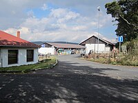
Older house in Mníšek
View of the frontier market

Wooden cross on the way to Nová Ves


literature
- Local history of the school district of Brüx - the judicial districts of Brüx, Oberleutensdorf, Katharinaberg. Publishing house of the German teachers' association in the districts of Brüx, Brüx 1908
Individual evidence
- ↑ http://www.uir.cz/katastralni-uzemi/706019/Mnisek-v-Krusnych-horach
- ↑ a b Historický lexikon obcí České republiky - 1869-2015. (PDF) Český statistický úřad, December 18, 2015, accessed on February 19, 2016 (Czech).
- ↑ Johann Gottfried Sommer The Kingdom of Bohemia , Vol. 14 Saatzer Kreis, 1846, p. 114.
- ^ Michael Rademacher: German administrative history from the unification of the empire in 1871 to the reunification in 1990. District of Brüx (Czech. Most). (Online material for the dissertation, Osnabrück 2006).
