Nová Ves v Horách
| Nová Ves v Horách | ||||
|---|---|---|---|---|
|
||||
| Basic data | ||||
| State : |
|
|||
| Region : | Ústecký kraj | |||
| District : | Must | |||
| Area : | 2627.5629 ha | |||
| Geographic location : | 50 ° 36 ' N , 13 ° 29' E | |||
| Height: | 640 m nm | |||
| Residents : | 466 (Jan 1, 2019) | |||
| Postal code : | 435 45 | |||
| License plate : | U | |||
| structure | ||||
| Status: | local community | |||
| Districts: | 4th | |||
| administration | ||||
| Mayor : | David Kádner (as of 2013) | |||
| Address: | Nová Ves v Horách 33 435 45 Nová Ves v Horách |
|||
| Municipality number: | 567329 | |||
| Website : | www.novavesvhorach.cz | |||
| Location of Nová Ves v Horách in the Most district | ||||

|
||||
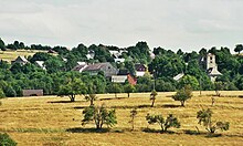
Nová Ves v Horách (German Gebirgsneudorf , formerly Rottendorf ) is a municipality in the Okres Most in the Czech Republic .
geography
The municipality of Nová Ves v Horách is located in the northwestern part of the country in the Bohemian Ore Mountains on the border with Saxony .
Community structure
The municipality of Nová Ves v Horách consists of the districts Lesná (Charge) , Mikulovice (Nickelsdorf) , Mníšek (Hermitage) and Nová Ves v Horách (Mountain New Village) as well as the settlements of Červená Jáma (Rothe Grube) and Lniště (Flax Ground) . The municipality is divided into the cadastral districts of Lesná v Krušných horách, Mikulovice v Krušných horách, Mníšek v Krušných horách and Nová Ves v Horách.
Neighboring places
| Deutschneudorf | Neuhausen / Erzgeb. | |
| Hora Svaté Kateřiny (Sankt Katharinaberg) |

|
Klíny (Göhren) |
| Boleboř (Göttersdorf), Vysoká Pec (Hohenofen) | Horní Jiřetín (Obergeorgenthal) | Litvínov (Oberleutensdorf) |
history
1564 was the first written mention in Hamfescht , issued at the Hněvín Castle in Brüx . The growing mining of ore and coal probably led to the foundation of the community. In 1585 the Brüx Castle and all the parishes were sold to Ladislav von Lobkowicz . In 1591 Bohuslav von Lobkowicz destroyed the Protestant church.
In 1599, 1611, 1613 and 1680 the plague depopulated the whole place. In 1629 the village was forcibly Catholicized. 44 houses were burned during the Swedish military occupation in 1639. In 1780–1784 a new church was built. In 1846 the village had 121 houses and 961 inhabitants, from 1850 it formed a community in the judicial district of Katharinaberg . The Mníšek Church, completed in 1916, was blown up in 1964.
In the 19th and 20th centuries, the population was mainly engaged in agriculture, the timber industry and the manufacture of toys. A large part of them worked in the mines in Saxony. After the end of World War II until 1947, the German residents about the internment were, according to the Benes decrees , expelled .
Attractions
- Church of the Archangel Michael, built 1779–1784
- Statue of St. John of Nepomuk, created 1777
- Lniště hunting lodge
- near the Mníšek district: the small Jeřabina (Haselstein) lookout tower
Sons and daughters of the church
- Harald Thiel (1931–2002), German artist


