Klíny
| Klíny | ||||
|---|---|---|---|---|
|
||||
| Basic data | ||||
| State : |
|
|||
| Region : | Ústecký kraj | |||
| District : | Must | |||
| Area : | 1843.2323 ha | |||
| Geographic location : | 50 ° 38 ' N , 13 ° 33' E | |||
| Height: | 812 m nm | |||
| Residents : | 143 (Jan. 1, 2019) | |||
| Postal code : | 436 01 | |||
| License plate : | U | |||
| traffic | ||||
| Street: | Horní Litvínov - Neuhausen | |||
| structure | ||||
| Status: | local community | |||
| Districts: | 3 | |||
| administration | ||||
| Mayor : | Jiří Matoušek (as of 2013) | |||
| Address: | Klíny 61 43601 Litvínov 1 |
|||
| Municipality number: | 567191 | |||
| Website : | mesta.obce.cz/kliny | |||
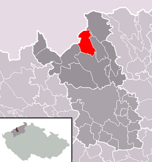
| Location of Klíny in the Most district | ||||

|
||||
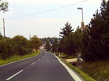
Klíny (German Göhren ) is a municipality in Okres Most in Ústecký kraj in the north of the Czech Republic . It is located six and a half kilometers northwest of Horní Litvínov .
geography
location
Klíny is located on a plateau of the Ore Mountains ridge near the German border, surrounded by the valleys of the Bílý potok (Flößbach , formerly the Gold River) , the Svídnice ( Schweinitz ) and the Loupnice (Frauenbach) . In the north rise the Pestrý ( Farbenhübel , 871 m) and the Jelení hlava ( deer head , 874 m), in the east the Černý vrch (889 m), the Studenec ( Höllberg , 878 m), the Loučná (956 m) and the Střelná ( Hohe Schuß , 868 m), in the southeast of the Holubí vrch ( Nitschenberg , 716 m), in the south of the Mračný vrch ( Göhrenberg , 852 m), in the southwest of the Kamenec ( Steinhübel , 814 m), in the west of the Brandhübel (781 m) m) and the Teichhübel (818 m) as well as in the northwest of the Kluge-Hübel (until 2004 roof height , 834 m). To the northeast lies the Fláje dam , in the east the deep valley Šumný důl (Rauschengrund) formed by the Bílý potok, and to the south the Janov dam . In the west, in the border area, extends the moorland of Deutscheinsiedel, which also includes Černý rybník , located on the north-western edge of the village . The Bílý potok and Svídnice rises near Klíny.
Community structure
The municipality of Klíny consists of the districts Klíny (Göhren) , Rašov (Rascha) and Sedlo (Zettl) . Basic settlement units are Klíny I, Klíny II, Rašov and Sedlo. The municipality is divided into the cadastral districts Klíny I, Klíny II and Rašov u Litvínova.
Neighboring places
| Neuhausen / Erzgeb. | Český Jiřetín (Georgendorf) | |
| Nová Ves v Horách (Mountain New Village) |

|
Meziboří (Schönbach) |
| Litvínov (Oberleutensdorf) |
Direct neighbors are Neuwernsdorf , Český Jiřetín and Fláje in the north, Jiřík in the northeast, Dlouhá Louka in the east, Meziboří , Sedlo and Rašov in the southeast, Lounice and Křižatky in the south, Mikulovice in the southwest, Mníšek , Deutscheinsiedel , Heidelberg and Bad Einsiedel in the west Heidelbach, Frauenbach and Rauschenbach in the northwest.
history
The first settlement on Černý rybník took place around 3000 BC. In the 12th century, miners from Saxony came to the area in the Hercynian Primeval Forest and mined silver ore in Klíny . The tunnels 1 and 7 were at the church, their mouth holes were later buried. At first the forest belonged to the Bohemian kings; but it soon came into the possession of various lords, including the Hrabischitzer , lords of Riesenburg .
The mountain village of St. Wenceslas Mountain (Hora Svatého Václava) was probably founded in the 14th century by the lords of Riesenburg, its name derives from the plateau of the same name. The toponym St. Wenceslasberg , however, only existed for a short time and was dropped in the 14th century. The first written mention of the village Gerij at St. Wenzelberg (villa Gerij in Monte S. Wenczeslai) took place in 1355 in the Confirmation books (Libri confirmationum) , as Slauko V of Riesenburg in 1354 he built the church of St.. Anthony of Padua a Had pastor installed. The village had previously been part of the Lutwinow parish . The first- appointed pastor Hermann received confirmation from the Archdiocese of Prague on April 17, 1355. At that time the church was actually only a small mountain chapel. Because of the low income in Gerij, no pleban lasted longer than three years. On August 7, 1357, pastor Klemens resigned and was replaced by the cleric Nicolaus from Lewin near Auscha . He was followed in 1362 by Mathias from Schlan , this on November 13, 1364 by Georg from Bischouitz (Puschwitz). Further mentions are then missing.
Because of over-indebtedness, the Borso d. Ä. and Borso d. J. von Riesenburg in 1398 sell the rule Riesenburg to Margrave Wilhelm I of Meissen . During the siege of Brüx by the Hussites , the Göhren church was probably also destroyed. After the Hussite Wars, most of the population became Protestant. With the Treaty of Eger in 1459, Riesenburg was again part of the Kingdom of Bohemia. In the 16th century, copper and lead were mined. In the course of time, the village was called Gery , Gerij-Jeren , Jerno , Ghern , Ghörn , Khern , na Klínach . The Bohemian name Klíny (German wedge ) arose because the village was wedged into the forest, as it were. When Theobald von Lobkowicz's sons were inherited on Dux in 1538, Göhren Wenzel Popel von Lobkowicz was given. On January 21, 1585, Emperor Rudolf II sold Göhren to Ladislaus von Lobkowicz , who fell out of favor ten years later. In 1595 Rudolf II sold the part of Göhren belonging to Hněvín Castle to the town of Brüx . After the Battle of the White Mountain , the share in Brüx was confiscated by Göhren (na Klínach) and transferred to Albrecht von Waldstein , as the city of Brüx had supported the Protestants financially. In the 1640s Göhren and Zettl were again looked after by the pastor in Obergeorgenthal . On July 16, 1666, Johann Friedrich von Waldstein acquired a share from Göhren including Zettl and Rascha and joined him to his rule Dux . The other part was returned to the city of Brüx; they united him with the Kopitz estate . In 1680 Johann Friedrich von Waldstein raised the lordships of Dux and Oberleutensdorf to a family affide . In the summer of 1680 the plague broke out in Bohemia . However, both parts of Göhren were largely spared. Mining stopped after the Thirty Years War . Thereafter, the residents were mostly lumberjacks, day laborers , a few farmers and factory workers. Agricultural products were hay, grain, oats (rarely ripe) and potatoes. In the village itself there was neither a baker nor a butcher, not even a shop. Charcoal was produced and hunting was carried out on the manor houses.
From 1794 Göhren also had an elected judge. From 1794 to 1809 it was Bernhard Garnick, from 1804 to 1806 Anton Geißler from Zettl, 1812 Josef Tropschuh, 1811 to 1820 Franz Josef Göpfert. The school went into operation in 1827 and the Göhren community was formed four years later from Göhren, Zettl and Rascha. Anton Geissler was elected as the first head, and municipal councilors were Josef Garnich and Michael Göpfert.
In 1831 Göhre or Göhrn consisted of 51 houses with 364 German-speaking residents. Of these, 36 houses with 252 inhabitants (Duxer Göhrn) to Dux and 15 houses with 112 inhabitants (Brüxer Göhrn) to Kopitz were subject . The forester's house belonged to the Dux side. Parish was Ober-Leitensdorf . Until the middle of the 19th century, Göhre remained partially subordinate to the Fideikommissherrschaft Dux and the city of Brüx.
After the abolition of patrimonial formed Göhren / Jerno 1850 a district of the municipality Johnsdorf in Leitmeritzer county and judicial district Brüx. At that time 391 people lived in the village. From 1868 the village belonged to the Brüx district . On July 7th, 1857 the landlord Josef Berger decided in his last will to build a new church, after which the foundation stone was laid. A misunderstanding with the property seller delayed the construction until 1870. The church of St. Anthony of Padua was then built at 784 m above sea level, surrounded by forests, in the Renaissance style with Romanesque windows. The painter Wilhelm Kandler created the main altarpiece of St. Anthony and the side altar painting of St. Wenceslaus. Chaplain Franz Schuldes was appointed the first pastor on April 17, 1871. However, each spring the church suffered from excessively high groundwater, which regularly flooded the entrance and stayed until early summer. The altar and the altar paintings were soon attacked by the moisture.
In 1876 Göhren / Klíny broke away from Johnsdorf and together with Rascha and Zettl formed their own community. From 1905 the community belonged to the newly formed court district Oberleutensdorf. In 1930 the community had 397 inhabitants; 255 of them lived in the district of Göhren. As a result of the Munich Agreement , Göhren was added to the German Reich in 1938 and belonged to the district of Brüx until 1945 . In 1939 354 people lived in the community. After the end of World War II, Klíny returned to Czechoslovakia and most of the German-Bohemian population was expelled. 1948 Klíny was assigned to the Okres Litvínov; since its abolition in 1961, the community has again belonged to Okres Most . In 1950 only 51 people lived in Klíny, compared to 105 in 1961 and 91 in 1970. Klíny became a recreational settlement during this time. In the years 1960 to 1962 the cemetery was leveled. The church, which had fallen into disrepair since the 1960s, was demolished in 1985. Since 2007 the community has had a coat of arms and a banner. Today, Klíny is a local recreation and winter sports resort with downhill runs and the Krušnohorská lyžařská magistrála (Ore Mountain Ski Route) for the residents of the Okres Most.
Attractions
- Wooden bell tower; the statue of the Virgin Mary of Lourdes inside comes from the demolished church.
Web links
Individual evidence
- ↑ http://www.uir.cz/obec/567191/Kliny
- ↑ Český statistický úřad - The population of the Czech municipalities as of January 1, 2019 (PDF; 7.4 MiB)
- ↑ http://www.uir.cz/casti-obce-obec/567191/Obec-Kliny
- ↑ http://www.uir.cz/zsj-obec/567191/Obec-Kliny
- ↑ http://www.uir.cz/katastralni-uzemi-obec/567191/Obec-Kliny
- ↑ Johann Gottfried Sommer: The Kingdom of Bohemia, Vol. 14: Saatzer circle. 1846, p. 114.
- ^ Johann Gottfried Sommer: The Kingdom of Bohemia, Vol. 1: Leitmeritzer circle. 1833, p. 145.
- ^ Michael Rademacher: German administrative history from the unification of the empire in 1871 to the reunification in 1990. District of Brüx (Czech. Most). (Online material for the dissertation, Osnabrück 2006).


