
Baie Lazare
|
Baie Lazare
district of Seychelles |
|
|---|---|
  |

|
| Geographic location : | |
| Island: | Mahé (Seychelles) |
| Surface: | 12.1 km² |
| Residents: | 3200 |
| Population density: | Inhabitants / km² |
| Motto: | Friendship and Unity for Progress |
| ISO 3166-2 code | SC-06 |
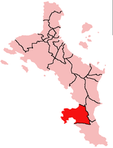
Baie Lazare is an administrative district of the Seychelles on the island of Mahé .
geography
_-_de_-_colored.svg)
The district is located on the southwest coast of Mahé. It is bounded by the districts of Anse Boileau , Anse Royale and Takamaka .
The named bay is located south of a headland that extends to the west. To the north, the Baie La Mouche closes the district. On the headland the most prominent elevation is the Conical Hill ( ⊙ ). The Baie Lazare is enclosed by the caps Pointe Lazare (W) and Pointe Maravi .
The district has ISO 3166-2 code SC-06.
Individual evidence
- ↑ (2009 update of the 2002 census) Government of the Seychelles: Statistical Bulletin, District Population 2007 and Population estimates 2008–2009 . National Statistics Bureau, Victoria 2009. ( Page no longer available , search in web archives ) Info: The link was automatically marked as broken. Please check the link according to the instructions and then remove this notice.
- ↑ geonames.org .
- ↑ iso.org .
Anse aux Pins |
Anse Boileau |
Anse Etoile |
Anse Royale |
Au Cap |
Baie Lazare |
Baie Sainte Anne |
Beau Vallon |
Bel Air |
Bel Ombre |
Cascade |
English River |
Glacis |
Grand Anse (Mahé) |
Grand Anse (Praslin) |
La Digue and Inner Islands |
Les Mamelles |
Mont Buxton |
Mont Fleuri |
Plaisance |
Pointe La Rue |
Port Glaud |
Roche Caïman |
Saint Louis |
Takamaka
no district: Outer Islands