
Mont Fleuri
|
Mont Fleuri
district of Seychelles |
|
|---|---|
 .svg) |

|
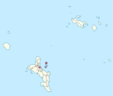
| Geographic location : |
Coordinates: 4 ° 38 ′ S , 55 ° 27 ′ E |
| Island: | Mahé (Seychelles) |
| Surface: | 6.1 km² |
| Residents: | 3607 |
| Population density: | 591 inhabitants / km² |
| Motto: | Surmount and Flourish |
| ISO 3166-2 code | SC-18 |

Mont Fleuri is one of the 25 administrative districts of the Seychelles . The district forms part of the capital Victoria and is located south of the city center. Mont Fleuri was considered a “Lower Middle Class” district in colonial times. Today the district is home to the country's major educational institutions, including the Polytechnic College , Teachers Training College, and the French and International Schools and other educational institutions. Other public institutions include the Victoria Hospital and the Departments of Foreign Affairs, Education and the Environment. The first settlers on the island of Mahé began to settle in Mont Fleuri along the Rochon River in 1771. In addition to the area on the main island of Mahé, the six islands in the Sainte Anne Marine National Park in front of the port of Victoria belong to the district, including Sainte Anne and Île au Cerf, on which there are hotels, and the island of Moyenne , which is both part of the Ste Anne Marine Parks is, as well as has the status of an independent national park. One of the attractions in Mont Fleuri is the botanical garden named after the district .
Individual evidence
- ↑ World Gazetteer website: Seychelles: Administrative division (population and area) . ( Memento of the original from December 29, 2011 in the Internet Archive ) Info: The archive link was automatically inserted and not yet checked. Please check the original and archive link according to the instructions and then remove this notice. Queryed on December 16, 2010.
- ^ Government of the Seychelles: Statistical Bulletin, Population and Vital Statistics No. 2 of 2010 . National Statistics Bureau, Victoria 2010. (PDF; 890 kB)
Anse aux Pins |
Anse Boileau |
Anse Etoile |
Anse Royale |
Au Cap |
Baie Lazare |
Baie Sainte Anne |
Beau Vallon |
Bel Air |
Bel Ombre |
Cascade |
English River |
Glacis |
Grand Anse (Mahé) |
Grand Anse (Praslin) |
La Digue and Inner Islands |
Les Mamelles |
Mont Buxton |
Mont Fleuri |
Plaisance |
Pointe La Rue |
Port Glaud |
Roche Caïman |
Saint Louis |
Takamaka
no district: Outer Islands