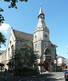
Banbury
Location in England
|
Banbury is a town on the River Cherwell in Oxfordshire ( England ). It is the administrative seat of the Cherwell district and an important economic and business center for the predominantly rural area.
Location and population
Banbury is 103 km northwest of London , 61 km southeast of Birmingham , 43 km south of Coventry and 34 km northwest of the county town of Oxford . Unofficially, this area is also known as Banburyshire , which includes the Cherwell district and parts of the neighboring counties of Northamptonshire and Warwickshire . In 2001, Banbury had 41,802 inhabitants, together with the surrounding parishes and parishes, the last census in 2011 gave 46,853 people.
history
The place has been inhabited since Roman times. There was a Roman villa at nearby Wykham Park. Banbury developed under strong Danish influence during the Anglo-Saxon period . Its medieval prosperity was based on wool. Banbury Castle was built in 1135 by order of the Bishops of Lincoln . In the English Civil War it was besieged, but not destroyed. Banbury was owned by the king and a royal city because of its proximity to Oxford, but the residents were strict puritans . During the English civil wars in the 1640s, Oliver Cromwell temporarily moved into the oldest pub in town - the “Ye Olde Reindeer Inn”. In the "Globe Room" of the same pub he is said to have planned the Edgehill fight, according to local legend. The castle was damaged after the war and later demolished.
Banbury is the birthplace of Banbury cakes , an English pastry specialty first prepared by Edward Welchman here in his pastry shop on Parsons Street in the 16th century .
The completion of the Oxford Canal in 1790 resulted in significant growth for the city. In 1850, Banbury was also connected to the railway network, which allowed a direct connection to London and the north. In place of the former castle, there is now a modern shopping center, Castle Quay .
During the Second World War , the so-called Banbury sheets ("Banbury sheets") were produced in Banbury , a cryptanalytic tool that the British Codebreakers (code breakers) in the town of Bletchley , about 50 km to the east, used to get into the with the rotor key machine Enigma to break into encrypted secret communications of the German Navy .
Banbury has been twinned with Hennef since 1981 .
economy
Mainly companies from the automotive supply industry, electrical industry, aluminum and food processing and printing plants have settled in Banbury. The Formula 1 teams Haas and Manor are based here.
On a former military airfield , the Royal Air Force Station Gaydon, RAF Gaydon for short, which existed between 1942 and 1974, is now the Heritage Motor Center , the headquarters of Aston Martin and a development center for Jaguar Land Rover . RAF Gaydon, about 17 km northwest of Banbury, was a location of the RAF Bomber Command during the Second World War and from 1955 the first operational base of the Vickers Valiant . The former British Leyland acquired the area in 1978 and from then on initially used it as a vehicle test center.
A little to the south is the American military base RAF Barford St John , a training airfield of the RAF Bomber Command during the Second World War . With the former RAF Chipping Warden station , about 10 km to the northeast, there is another bomber school airfield from the wartime, which is now used as an industrial site.
sons and daughters of the town
- Richard Bevan Braithwaite (1900–1990), philosopher and science theorist
- Alan Lloyd Hodgkin (1914–1998), biochemist and Nobel Prize winner
- Rodney Gould (born 1943), motorcycle racer
- Gary Glitter (* 1944), rock 'n' roll musician
- Will Bratt (* 1988), racing driver
Web links
Individual evidence
- ^ Manor - Formula One Team. (No longer available online.) In: manorf1team.com. Archived from the original on March 14, 2015 ; accessed on March 17, 2016 . Info: The archive link was inserted automatically and has not yet been checked. Please check the original and archive link according to the instructions and then remove this notice.
Coordinates: 52 ° 4 ′ N , 1 ° 20 ′ W


