Bandabari
|
Bandabari district |
|
|---|---|
| Coordinates | 13 ° 32 ' N , 2 ° 8' E |
| Basic data | |
| Country | Niger |
| Niamey | |
| Arrondissement | Niamey III |
| ISO 3166-2 | NE-8 |
| Residents | 695 (2012) |
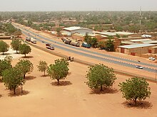
Bandabari is a neighborhood ( French : quartier ) in the Arrondissement Niamey III of the city of Niamey in Niger .
geography

Bandabari is located east of Niamey's historic city center. The surrounding districts are Couronne North in the northwest, Banifandou II in the northeast, Route Filingué in the southeast and Madina in the southwest. The district is located in a plateau with a sand layer more than 2.5 meters deep, which allows better infiltration than in other parts of the city.
The standard scheme for street names in Bandabari is rue MD 1 , where the French rue for street is followed by MD for Madina and finally a number. This goes back to a project to name streets in Niamey in 2002, in which the city was divided into 44 zones, each with its own letter abbreviations. These zones do not necessarily coincide with the administrative boundaries of the eponymous districts. The rue MD 1 scheme is used not only in Madina but also in Bandabari.
history
Bandabari was created during a drought in the 1960s through immigration from the Zarma areas around the city. The place name comes from the Zarma language and means "turn your back". This indicates the inability to share food with relatives and friends. From its original character as a refugee settlement, there was soon nothing to be seen in Bandabari. With the division of Niamey into five districts in 1979, Bandabari became part of the 3rd district, which in 1989 with the 4th district in the sub-municipality Niamey II, which in turn was dissolved in 1996 in the previous form.
population
At the 2012 census, Bandabari had 695 residents who lived in 125 households.
Infrastructure
There are several public primary schools in Bandabari. The oldest, the Ecole primaire de Bandabari I , was founded in 1977.
literature
- Z. Sountalma: Modèles socio-culturels et habitat à Niamey: le cas du quartier Bandabari . Mémoire de DEA. Université Paris VII, Paris 1983.
Web links
Individual evidence
- ↑ a b National Repertoire des Localités (ReNaLoc). (RAR) Institut National de la Statistique de la République du Niger, July 2014, p. 716 , accessed on 7 August 2015 (French).
- ↑ Hamadou Issaka, Dominique Badariotti: Les inondations à Niamey, enjeux autour d'un phenomène complexe . In: Cahiers d'Outre-Mer . No. 263 , September 2013, p. 384 ( journals.openedition.org [accessed April 21, 2019]).
- ↑ Catherine Farvacque-Vitkovic, Lucien Godin, Hugues Leroux, Florence Verdet, Roberto Chavez: Street Addressing and the Management of Cities . World Bank, Washington, DC 2005, ISBN 0-8213-5815-4 , pp. 85 and 89 .
- ↑ Abdourahmane Idrissa, Samuel Decalo: Historical Dictionary of Niger . 4th edition. Scarecrow, Plymouth 2012, ISBN 0-7864-0495-7 , pp. 336 .
- ↑ Kokou Henri Motcho: Niamey, Garin captan Salma ou l'histoire du peuplement de la ville de Niamey . In: Jérôme Aloko-N'Guessan, Amadou Diallo, Kokou Henri Motcho (eds.): Villes et organization de l'espace en Afrique . Karthala, Paris 2010, ISBN 978-2-8111-0339-2 , pp. 23 .
- ↑ Daniel Barreteau, Ali Daouda: Systèmes éducatifs et multilinguisme au Niger. Results scolaires, double flux . Orstom / Université Abdou Moumouni de Niamey, Paris / Niamey 1997, ISBN 2-7099-1365-8 , p. 86 ( horizon.documentation.ird.fr [PDF; accessed 29 May 2019]).
