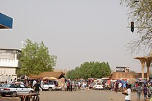
Banizoumbou (Niamey)
|
Neighborhood Banizoumbou |
|
|---|---|
| Coordinates | 13 ° 31 ' N , 2 ° 7' E |
| Basic data | |
| Country | Niger |
| Niamey | |
| Arrondissement | Niamey III |
| ISO 3166-2 | NE-8 |
| Residents | 3216 (2012) |
Banizoumbou (also: Banizoubou ) is a district ( French : quartier ) in the Arrondissement Niamey III of the city of Niamey in Niger .
geography

Banizoumbou is located in Niamey city center between Boulevard de la Liberté and Boulevard de l'Indépendance. The neighboring districts are Abidjan or its part Balafon in the northeast, Lacouroussou in the southeast, Kalley Center in the south, Maourey in the southwest and Gandatché in the west. The district is located in a plateau with a sand layer more than 2.5 meters deep, which allows better infiltration than in other parts of the city.
Banizoumbou covers an area of about 30.8 hectares . Of this, 6.9 hectares, more than a fifth, are taken up by the market area of the Grand Marché . The standard scheme for street names in Banizoumbou and other districts is rue GM 1 , where the French rue for street is followed by the abbreviation GM for Grand Marché and finally a number. This goes back to a project to name streets in Niamey in 2002, in which the city was divided into 44 zones, each with its own letter abbreviations.
history
The district goes back to the French colonial era, which lasted until 1960. Historically, it is the northeast of the Koira Tagui district at its original location.
population
At the 2012 census, Banizoumbou had 3,216 inhabitants who lived in 606 households. At the 2001 census, the population was 3,694 in 606 households, and at the 1988 census, the population was 6,082 in 1,015 households.

Infrastructure
The public primary school Ecole primaire de Banizoumbou was founded in 1978.
Web links
Individual evidence
- ↑ Hamadou Issaka, Dominique Badariotti: Les inondations à Niamey, enjeux autour d'un phenomène complexe . In: Cahiers d'Outre-Mer . No. 263 , September 2013, p. 383–384 ( journals.openedition.org [accessed April 21, 2019]).
- ^ The Study on Sanitation Improvement for the Niamey City in Republic of Niger. Appendix F: Existing Urban Conditions. (PDF) Japan International Cooperation Agency (JICA), August 2000, p. F-4 , accessed on April 19, 2019 .
- ↑ Catherine Farvacque-Vitkovic, Lucien Godin, Hugues Leroux, Florence Verdet, Roberto Chavez: Street Addressing and the Management of Cities . World Bank, Washington, DC 2005, ISBN 0-8213-5815-4 , pp. 85 and 89 .
- ↑ Apollinaire Tini: La gestion des déchets solid ménagers à Niamey au Niger: essai pour une stratégie de gestion durable . Thèse de doctorat. Institut National des Sciences Appliquées de Lyon, Lyon 2003, p. 43 ( theses.insa-lyon.fr [PDF; accessed May 1, 2019]).
- ↑ Arouna Hamidou Sidikou : Niamey . In: Les Cahiers d'Outre-Mer . No. 111 , September 1975, p. 212 ( persee.fr [accessed May 5, 2019]).
- ↑ Répertoire National des localites (ReNaLoc). (RAR) Institut National de la Statistique de la République du Niger, July 2014, p. 716 , accessed on 7 August 2015 (French).
- ^ Répertoire National des Communes (RENACOM). (RAR) Institut National de la Statistique de la République du Niger, accessed on November 8, 2010 (French).
- ↑ Recensement Général de la Population 1988: Répertoire National des Villages du Niger . Bureau Central de Recensement, Ministère du Plan, République du Niger, Niamey March 1991, p. 225 ( web.archive.org [PDF; accessed May 4, 2019]).
- ↑ Daniel Barreteau, Ali Daouda: Systèmes éducatifs et multilinguisme au Niger. Results scolaires, double flux . Orstom / Université Abdou Moumouni de Niamey, Paris / Niamey 1997, ISBN 2-7099-1365-8 , p. 85 ( horizon.documentation.ird.fr [PDF; accessed May 29, 2019]).