
Cité Fayçal (Niamey)
|
District Cité Fayçal |
|
|---|---|
| Coordinates | 13 ° 30 ' N , 2 ° 8' E |
| Basic data | |
| Country | Niger |
| Niamey | |
| Arrondissement | Niamey III |
| ISO 3166-2 | NE-8 |
| Residents | 1390 (2012) |
Cité Fayçal is a neighborhood ( French : quartier ) in the Arrondissement Niamey III of the city of Niamey in Niger .
geography
(1).jpg)
(1).jpg)
Cité Fayçal is located in the southeast of the urban municipality of Niamey. The district is bordered by the streets of Boulevard du 15 Avril, Avenue de l'OUA, Boulevard de l'Indépendance and Boulevard Tanimoune. The neighboring districts are Nouveau Marché in the northwest, Poudrière in the northeast and Gamkalley Golley in the south. In the southeast, Cité Fayçal is bordered by the Niamey train station and in the west by the Garba-Hassane barracks . The district extends over an area of about 29.5 hectares and is located in a plateau with a layer of sand less than 2.5 meters deep, which means that only limited infiltration is possible.
The standard scheme for street names in Cité Fayçal is rue CI 1 , with the French rue for street followed by CI for Cité and finally a number. This goes back to a project to name streets in Niamey in 2002, in which the city was divided into 44 zones, each with its own letter abbreviations. These zones do not necessarily coincide with the administrative boundaries of the eponymous districts. The rue CI 1 scheme is used not only in Cité Fayçal, but also in parts of Poudrière.
history
The Cité Fayçal district was founded in 1972. Here, apartments of medium and high standards were built for higher officials. Cité is the French word for "city", Fayçal is the French spelling of Faisal , the king of Saudi Arabia who was murdered in 1975 .
population
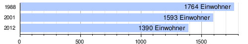
At the 2012 census, Cité Fayçal had 1,390 inhabitants who lived in 210 households. At the 2001 census, the population was 1,593 in 246 households, and at the 1988 census, the population was 1,764 in 235 households.
Infrastructure
There is a health center in the district with a Center de Santé Intégré (CSI).
Web links
Individual evidence
- ↑ a b Hamadou Issaka, Dominique Badariotti: Les inondations à Niamey, enjeux autour d'un phenomène complexe . In: Cahiers d'Outre-Mer . No. 263 , September 2013, p. 383–384 ( journals.openedition.org [accessed April 21, 2019]).
- ^ The Study on Sanitation Improvement for the Niamey City in Republic of Niger. Appendix F: Existing Urban Conditions. (PDF) Japan International Cooperation Agency (JICA), August 2000, p. F-4 , accessed on April 19, 2019 .
- ↑ Catherine Farvacque-Vitkovic, Lucien Godin, Hugues Leroux, Florence Verdet, Roberto Chavez: Street Addressing and the Management of Cities . World Bank, Washington, DC 2005, ISBN 0-8213-5815-4 , pp. 85 and 89 .
- ^ Benjamin Michelon, Laurence Wilhelm, Ibrahima Goumey: Diagnostic de l'armature commerciale de la ville de Niamey. Final report. (PDF) Groupe Huit, March 2015, p. 13 , accessed on April 20, 2019 (French).
- ↑ Répertoire National des localites (ReNaLoc). (RAR) Institut National de la Statistique de la République du Niger, July 2014, p. 716 , accessed on 7 August 2015 (French).
- ^ Répertoire National des Communes (RENACOM). (RAR) Institut National de la Statistique de la République du Niger, accessed on November 8, 2010 (French).
- ↑ Recensement Général de la Population 1988: Répertoire National des Villages du Niger . Bureau Central de Recensement, Ministère du Plan, République du Niger, Niamey March 1991, p. 225 ( web.archive.org [PDF; accessed May 4, 2019]).
- ^ Niger DSS. In: Systems Nationale d'Information Sanitaire (SNIS). Ministère de la Santé Publique, République du Niger, accessed on June 9, 2019 (French).