
Barbès - Rochechouart (Paris Métro)
|
|
|
|---|---|

|
|
| Tariff zone | 1 |
| Line (s) |
|
| place | Paris IX , X , XVIII |
| opening | March 26, 1903 |


Barbès - Rochechouart [ barbɛsrɔʃɛʃwa ] is a transfer station of the Paris Métro . It is served by lines 2 and 4 . Before 1907 it was called "Boulevard Barbès".
location
The metro station is located on the south-eastern edge of Montmartre , on the border of the Quartier de Rochechouart of the 9th arrondissement with the Quartier Saint-Vincent-de-Paul of the 10th arrondissement and the Quartiers de Clignancourt and de la Goutte d'Or des 18th arrondissements of Paris . The station of line 2 is located as a high station above the median of the Boulevard de la Chapelle east of the intersection with the Boulevard Barbès - Boulevard de Magenta street . The underground station of line 4 is located in the axis of this street under the aforementioned intersection.
Surname
It is named after the adjacent streets, Boulevard Barbès and Boulevard de Rochechouart. Armand Barbès was a revolutionary French republican during the uprising against King Ludwig Philip and in the February 1848 Revolution . Marguerite de Rochechouart was the abbess of the Benedictine Abbey of Montmartre, which was closed in 1790 .
history
On January 31, 1903, the eastern extension of line 2 from Anvers to Bagnolet (since 1970: Alexandre Dumas ) was put into operation. The station of line 2 was opened on March 26, 1903, until then the trains drove through without stopping.
The opening of the station of line 4 took place on April 21, 1908, when the first section from Porte de Clignancourt to Châtelet was opened.
description

Both stations have side platforms on two main tracks each. The elevated station of line 2 is above ground at the western beginning of a 2.2 kilometer long viaduct section . The structure of this station largely corresponds to that of the other stations in the elevated position of Line 2. The station is 75 m long and has 4.10 m wide side platforms on two parallel tracks. At the western end of the station, the platforms were subsequently widened on both sides to a length of approx. 20 m.
Two longitudinal beams, each resting on a row of iron columns, carry the track bed and the inner edges of the platforms. Their outer edges and the side walls rest on two further longitudinal girders, which are supported by brick pillars. At each of the four corners of the station, a pillar protrudes over the roof edge for design reasons. The platforms are covered in full length, the side walls are glazed. To the west, along Boulevard de Rochechouart, there is a ramp to the Anvers station in the tunnel .
The station of line 4 is located in the tunnel and is slightly inclined, it crosses line 2 in a curve almost at right angles. Their cross-section is elliptical , the side walls follow the curvature of the ellipse. The ceiling and walls are tiled in white. In the middle of the station, the vault is broken through by the distribution level. The station was originally also 75 m long, in the mid-1960s it was extended to 90 m and the line converted for the use of rubber-tired trains .
The entrances to line 2 are on the above. Crossing and at the junction with Rue Guy Patin. In the middle under the elevated railway station, stairs, escalators and elevators are used to change between the two lines. In the median of the Boulevard de Rochechouart, under the elevated railway viaduct, there are two further entrances to the underground distribution level above the line 4 station. They are each marked with a yellow “M” in a double circle after the entrance decor designed by Hector Guimard was dismantled in 1987.
vehicles
Conventional trains run on Line 2, since 2008 and now exclusively the MF 01 series . In the early years, two-axle vehicles were used, which were later replaced by five-car trains from Sprague-Thomson . The latter stayed on the line until 1981, with mixed operation with the successor series MF 67 from 1979 .
The vehicles on line 4 run on nitrogen-filled rubber tires, six-car trains from the MP 59 series replaced the five-car trains of the “classic” Sprague-Thomson design between 1966 and 1967. The MP 89 CC series currently operates on Line 4 .
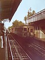
Sprague-Thomson type train leaves Line 2 station for Nation , 1977

MF-67 train in the elevated station, 2008

Station of line 4 with a rubber-tyred train of the MP 59 series departing southwards , 2010

MP 89 CC in the station of Line 4 during its renovation, 2017


_MP59_par_Cramos.JPG)

Others

On August 10, 1903 at around 6:53 p.m. on the ramp between the Anvers and Boulevard Barbès stations, a short circuit in a vehicle caused a smoldering fire . It triggered the disaster in the Couronnes and Ménilmontant train stations , in the course of which 84 people died.
On August 21, 1941, the Resistance fighter Pierre Georges shot and killed the German officer candidate Alfons Moser in the station of Line 4 . This act is considered to be the first attempt on the German occupation forces in France during World War II .
Remarks
- ↑ To distinguish it from Line 2 South (today Line 6 ) it was called Line 2 North until October 14, 1907
- ↑ The side walls of the similarly constructed elevated railway stations on line 6 are bricked and the tracks are also covered
- ↑ The dismantled parts have since adorned the entrance to the Bolivar station on line 7bis
- ↑ CC means "Conduite Conducteur" (driver-controlled), in contrast to the driverless type MP 89 CA
Web links
literature
- Gérard Roland: Stations de métro. D'Abbesses à Wagram . 2003, ISBN 2-86253-307-6 .
Individual evidence
- ↑ a b Jean Tricoire: Un siècle de métro en 14 lignes. De Bienvenüe à Météor . 2nd Edition. La Vie du Rail, Paris 2000, ISBN 2-902808-87-9 , p. 157 .
- ↑ Jean Tricoire: op. Cit. P. 150.
- ↑ a b Jean Tricoire: op. Cit. P. 183 f.
- ^ A b Brian Hardy: Paris Metro Handbook . 3. Edition. Capital Transport Publishing, Harrow Weald 1999, ISBN 1-85414-212-7 , pp. 36 .
- ↑ Jean Tricoire: op.cit. P. 51.
- ↑ Jean Tricoire: op.cit. P. 53.
- ↑ Jean Tricoire: op.cit. P. 18 f.
| Previous station | Paris metro | Next station |
|---|---|---|
|
Anvers ← Porte Dauphine |
|
La Chapelle Nation → |
|
Château Rouge ← Porte de Clignancourt |
|
Gare du Nord Mairie de Montrouge → |
Coordinates: 48 ° 53 ′ 1.5 ″ N , 2 ° 20 ′ 59.6 ″ E