Barrhead (East Renfrewshire)
|
Barrhead Scottish Gaelic Ceann a 'Bhàirr |
||
|---|---|---|
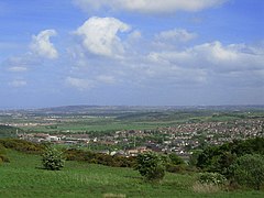
| View over Barrhead | ||
| Coordinates | 55 ° 48 ′ N , 4 ° 23 ′ W | |
|
|
||
| Residents | 17,443 2011 census | |
| administration | ||
| Post town | GLASGOW | |
| ZIP code section | G78 | |
| prefix | 0141 | |
| Part of the country | Scotland | |
| Council area | East Renfrewshire | |
| British Parliament | East Renfrewshire | |
| Scottish Parliament | Renfrewshire South | |
Barrhead ( Gaelic : Ceann a 'Bhàirr ) is a town in the Scottish council area of East Renfrewshire .
geography
The city lies in the north of East Renfrewshire and has a border with the Council Area Glasgow to the north . The city center of Glasgow is about eleven kilometers northeast. Another border exists with the council area Renfrewshire to the west . The center of the local town of Paisley is about six kilometers away in a north-westerly direction. Barrhead is part of the Glasgow agglomeration belt. It lies on the small river Levern , which flows a few kilometers south of Long Loch and flows into one of the two headwaters of the Cart in Glasgow . Ferenze Hill, around 180 m high, is located on the eastern edge .
history
Barrhead developed in the course of industrialization from several adjacent towns. The city was founded around 1773. The textile industry was mainly responsible for the rapid population growth. Many businesses in this branch of industry developed in Barrhead, including cotton mills, dye works and fabric printing plants. There were also iron or wood processing companies and stoneware manufacturers. In the nearby quarry Boylestone was also copper degraded. In 1894 Barrhead received the rights of a burgh . In the course of this, buildings for the Burgh Council (now 124 Main Street ) and a courthouse ( 128 Main Street ) were built. Today Barrhead is still industrial. Among other things, leather goods and pet food are produced there.
In 1841 there were 3,492 people in Barrhead. Ten years later, the number had almost doubled to 6069, but then remained almost constant for two more decades. From 12,971 inhabitants in 1961, the population grew to its peak of 18,420 in 1981. In 2011, 17,443 was counted in Barrhead.
traffic
Barrhead is on the A736 which starts north on the A8 and M8 in Glasgow. The road runs through the southern Glasgow boroughs, Barrhead and Neilston to end in the south in Irvine . The M77 passes Barrhead two miles east. In 1847 Barrhead was connected to the rail network and received its own station on the newly formed Glasgow, Barrhead and Neilston Direct Railway . For this purpose, a crossing of the Levern north of the city was created with the Salterland Viaduct . Today the station is on the Glasgow South Western Line of the First ScotRail operates. The Glasgow Airport is located eight kilometers to the northwest.
Attractions
There are currently 13 listed structures in Barrhead. Eight of these are listed in category B and five in category C. These include the Bourock Parish Church and the Barrhead South Parish Church, two church buildings from the mid-19th century. There are also five mansions, two bridges each and administration buildings, a stables and the Masonic Temple of Barrhead . In the district Arthurlie is the Arthur's Cross (also Arthurlie cross an historic), the stem preserved Celtic Cross from the 10th or 11th century, a Scheduled Monument found in Barrhead. It stood on Arthurlie House's grounds for a while , but that was not where it was originally.
sons and daughters of the town
- John Davidson (1857-1909), poet
- Edward Arthur Walton (1860-1922), painter
- Robert Stevenson (1869–?), Former football player
- Tommy McInally (1899–1955), former Scottish football player
- Ellen Dawson (1900–1967), communist activist and leader of the American Textile Union
- Bob McPhail (1905-2000), former football player
- Matthew McDiarmid (1914–1996), essayist and poet
- Alex McLeish (* 1959), former Scottish soccer player
- Marianne Saliba (* 1960), Australian politician
- Douglas Henshall (born 1965), actor
- Gordon McCorkell (born 1983), actor
Individual evidence
- ^ List of Gaelic expressions
- ↑ a b c d Barrhead East Renfrewshire. In: David Munro, Bruce Gittings: Scotland. An Encyclopedia of Places & Landscapes. Collins et al., Glasgow 2006, ISBN 0-00-472466-6 .
- ↑ a b c d Barrhead. In: Francis H. Groome: Ordnance Gazetteer of Scotland: A Survey of Scottish Topography, Statistical, Biographical and Historical. Volume 1: (A - Coru). Thomas C. Jack, Grange Publishing Works, Edinburgh et al. 1882, pp . 131-132 .
- ^ Levern Water. In: David Munro, Bruce Gittings: Scotland. An Encyclopedia of Places & Landscapes. Collins et al., Glasgow 2006, ISBN 0-00-472466-6 .
- ↑ Listed Building - Entry . In: Historic Scotland .
- ↑ Listed Building - Entry . In: Historic Scotland .
- ↑ entry. In: The Gazetteer for Scotland. 2011.
- ↑ 2011 census
- ↑ Listed Building - Entry . In: Historic Scotland .
- ↑ Scheduled Monument - Entry . In: Historic Scotland .


