Baumgarten (Dietersburg)
|
Baumgarten
Community Dietersburg
Coordinates: 48 ° 29 ′ 43 ″ N , 12 ° 59 ′ 29 ″ E
|
||
|---|---|---|
| Height : | 447 m above sea level NHN | |
| Residents : | 200 (May 25 1987) | |
| Incorporation : | July 1, 1971 | |
| Area code : | 08565 | |
|
Location of Baumgarten in Bavaria |
||
|
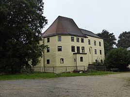
Baumgarten Castle
|
||
Baumgarten is a part of the municipality of Dietersburg in the Lower Bavarian district of Rottal-Inn . Until 1971 it formed an independent municipality.
location
The church village Baumgarten is located about four kilometers east of Dietersburg in the Isar-Inn hill country .
history
Baumgarten owes its foundation to the Romans. The place was on a Roman road that led from Haidenburg via Baumgarten to Pfarrkirchen . Baumgarten was the ancestral seat of the nobles von Baumgarten as early as the 12th century . A certain Dietricus de Pomgarten is cited as a seal witness around 1130. This family died out in 1338 with Georg von Baumgarten. In the following years, the Counts of Hals can be identified as the legal owners. After the last count of this family died, Baumgarten fell to the Landgraves of Leuchtenberg , who, however, after a short time declared their surrender in favor of the Counts of Ortenburg . Around 1417 the people of Siegenheim became the owners of Baumgarten.
On August 24, 1456, Friedrich Pienzenau zu Hartmannsberg became the new lord of the fortress, dwelling and yard of Baumgarten. In 1565 the Pienzenauer also acquired the property in Peterskirchen ; since then Baumgarten and Peterskirchen have been merged into one estate. Other owners followed: in 1640 the nobles of Hienheim, in 1673 the counts of Rheinstein and in 1821 the counts of Arco-Valley . The castle is still in their possession today. From 1821 to 1848, the Hofmark was followed by the second class Baumgarten patrimonial court , which was in the hands of the Counts of Arco-Valley.
The Baumgarten community emerged from the tax district of the same name in 1818. In 1964 it had 42 districts and belonged to the Pfarrkirchen district . On July 1, 1971, the municipality of Baumgarten was incorporated into the municipality of Dietersburg as part of the regional reform . In 1987 Baumgarten had 200 inhabitants.
Attractions
- Baumgarten Castle was built in the early Renaissance style in the 16th century and later changed several times. Towards the end of the war it served as a refugee camp and after the war from 1948 to 1961 as a retirement home.
- The castle chapel of St. Bartholomew was built in 1796 on the foundations of an earlier chapel in the classical style. On Easter vigil in 1988 it was badly damaged by fire. Countess Monica auf Valley financed the restoration for the most part, so that services could be held in the chapel again in 1991.
societies
- Baumgarten senior citizens' club
- Bayer. Red Cross, Service Group Egglham-Baumgarten
- DJK-SV Peterskirchen / Baumgarten
- Baumgarten volunteer fire department
- Beekeeping Association Baumgarten-Peterskirchen
- Catholic women's association Peterskirchen-Baumgarten
- Small animal breeding association Baumgarten
- Warrior u. Soldier comradeship Baumgarten
- Baumgarten tennis club
- Water bird shooters Baumgarten
literature
- Ilse Louis: Parish churches. The nursing courts Reichenberg and Julbach and the rule Ering-Frauenstein . I / XXXI in the Historical Atlas of Bavaria , Munich 1973 ( digitized ).
Web links
- Baumgarten in the location database of the Bayerische Landesbibliothek Online . Bavarian State Library
Individual evidence
- ↑ Bavarian State Office for Statistics and Data Processing (Ed.): Official local directory for Bavaria, territorial status: May 25, 1987 . Issue 450 of the articles on Bavaria's statistics. Munich November 1991, DNB 94240937X , p. 218 ( digitized version ).


