Bedersdorf
|
Bedersdorf
Wallerfangen municipality
|
||
|---|---|---|
| Coordinates: 49 ° 18 ′ 11 " N , 6 ° 38 ′ 31" E | ||
| Height : | 279 m | |
| Area : | 2.21 km² | |
| Residents : | 336 (2007) | |
| Population density : | 152 inhabitants / km² | |
| Incorporation : | 1st January 1974 | |
| Postal code : | 66798 | |
| Area code : | 06837 | |
|
Location of Bedersdorf in Saarland |
||
|
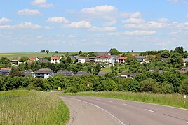
View of Bedersdorf
|
||
Bedersdorf (Saarländisch Bäddaschtroff ) is a district of the municipality Wallerfangen in the district of Saarlouis ( Saarland ). Bedersdorf was an independent municipality until the end of 1973.
Bedersdorf lies on the Saargau . The local church of St. Margaretha , the village fountain and the Lorraine farmhouses are well worth seeing .
history
The earliest coin finds from Bedersdorf show that the area was already settled at the time of the Roman emperor Diocletian (284–305). Bedersdorf was first mentioned in a document in 1030, when the Margravine Jutta von Lothringen donated goods and rights to the tithe of “Beterstorf” of the St. Matthias Abbey in Trier .
As part of the regional and administrative reform in Saarland , the previously independent municipality of Bedersdorf was assigned to the municipality of Wallerfangen on January 1, 1974 . Bedersdorf has been a district and a municipality since then.
Web links
Individual evidence
- ↑ Geoplatt ( Memento of November 13, 2007 in the Internet Archive )
- ^ Bedersdorf ( Memento from April 22, 2009 in the Internet Archive ), wallerfangen.de
- ^ Federal Statistical Office (ed.): Historical municipality directory for the Federal Republic of Germany. Name, border and key number changes in municipalities, counties and administrative districts from May 27, 1970 to December 31, 1982 . W. Kohlhammer, Stuttgart / Mainz 1983, ISBN 3-17-003263-1 , p. 808 .


