
Kerlingen
|
Kerlingen
Wallerfangen municipality
Coordinates: 49 ° 19 ′ 2 " N , 6 ° 39 ′ 3" E
|
||
|---|---|---|
| Height : | 330 m | |
| Area : | 4.26 km² | |
| Residents : | 625 (December 31, 2008) | |
| Population density : | 147 inhabitants / km² | |
| Incorporation : | 1st January 1974 | |
| Postal code : | 66798 | |
| Area code : | 06837 | |
Location of Kerlingen in Saarland |
||
 Kerlingen in Saargau
|
||

Kerlingen is a district of the municipality Wallerfangen in the district of Saarlouis ( Saarland ). Kerlingen was an independent municipality until the end of 1973.
geography
Kerlingen is located in the Saargau on the southwest slope of the Scheidberg.
history
The oldest documented mention of the place under the name Kirlinga took place around 950. In later documents the spellings Karlingis (1123), Keirlingen (1183), Kirlingen (1294), Kerlinga and Kerchelingen (1356), Kerling-lès- Sarrelouis (19th century).
In 1154 Kerlingen was named in connection with the Abbey Fraulautern in an allodium to "Kyrlingen".
Like many other places in the Saargau, Kerlingen belonged to the Duchy of Lorraine for a long time and to France until the beginning of the 19th century.
As part of the Saarland regional and administrative reform , the previously independent municipality of Kerlingen was assigned to the municipality of Wallerfangen on January 1, 1974 . Kerlingen has been a district and a municipality since then.
Attractions
The “Three Capuchins”, a Gallo-Roman rock relief, can be found near Kerlingen. The Celtic deities Nantosuelta and Sucellus are said to be depicted . Nantusuelta was the patron goddess of house and court, but also of the underworld. She was holding a staff with a small house on top. This represented the connection of the good spirits underground with the human world. Sucellus was the god of miners and blacksmiths, agriculture and the forest.
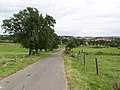
Dirt road to Kerlingen
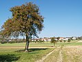
Kerlingen (fields)
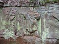
"Three Capuchins" (Gallo-Roman relief)


Individual evidence
- ^ Federal Statistical Office (ed.): Historical municipality directory for the Federal Republic of Germany. Name, border and key number changes in municipalities, counties and administrative districts from May 27, 1970 to December 31, 1982 . W. Kohlhammer, Stuttgart / Mainz 1983, ISBN 3-17-003263-1 , p. 808 .
Web links
- Kerlingen at www.wallerfangen.de
- Kerlingen at saarlandbilder.net
- Literature on Kerlingen in the Saarland Bibliography
Bedersdorf | Düren | Gisingen | Him | Ittersdorf | Kerlingen | Leidingen | Oberlimberg | Rammelffang | St. Barbara | Catfish catch