
Belgian Quarter (Cologne)
.jpg)


The Belgian Quarter is an inner-city district of Cologne in the southern Neustadt-Nord and is one of the most popular and expensive residential areas in the city. Its name is derived from the street names that refer to Belgian provinces or cities. Specifically, these are the cities of Antwerp , Ghent , Brussels and Liege as well as the provinces of Brabant , Limburg and the Flanders region . In addition, the Maastricht and Utrecht Strasse refer to Dutch cities.
history
middle Ages
Today's Brussels Street and Moltkestrasse were once part of the medieval Bischofsweg . The smaller northern part of Brusseler Strasse (between Antwerpener Strasse and Venloer Strasse ) runs on the old medieval Bischofsweg, the middle part (between Aachener Strasse and Antwerpener Strasse) on the new Bischofsweg. The southern part of Moltkestrasse (between Jülicher Strasse and Aachener Strasse) is based on the new Bischofsweg. Horticulture prevailed in the area between the medieval city wall and Bischofsweg, while agriculture and cattle breeding predominated in the outer castle area. Horticulture concentrated on growing vegetables and viticulture on small plots delimited by fences or walls. Evidently since 1474/75 there was no permanent settlement within the agricultural area, not even in the later Belgian Quarter, which remained uninhabited until the founding period .
The medieval Bischofsweg formed the city limits, the elector considered the Bischofsweg, which ran about 250 to 800 meters in front of the city wall, as the border. The Bischofsweg contained a plot of land of 368 hectares.
Founding period
In the French era , the Bischofsweg formed the border between the cantons of Weiden and Cologne from February 5, 1799 . It was abandoned as a city boundary in November 1883.
The city architect Josef Stübben presented plans for the city expansion on October 14, 1881. He received the order to have the walls of the medieval city fortifications with their 12 gates largely dismantled and to create a spacious and magnificent ring boulevard in their place . With the first breakthrough of the city wall on Gereonswall on June 18, 1881 and its further demolition, the steadily growing city had the opportunity to expand into the area in front of the field in the area of today's Cologne Neustadt - for which building was previously prohibited .

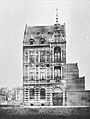
Brabanter Straße 74 - one of the first houses in the district (1884)

Antwerpener Strasse 75 / corner of Friesenplatz (1884)
Maastrichter Strasse 45 (1885)

Flanders Street (around 1890)

Brusseler Strasse / corner of Neue Maastrichter Strasse (around 1890)

Antwerpener Strasse (around 1898)

Brussels Square with St. Michael's Church (1908)


The Cologne architect Carl August Philipp had already submitted a development plan for the fortress terrain in 1879. He was a member of the Belgian “Capitalist Consortium”, which on June 17, 1878 had submitted an offer of 11.794 million Reichsmarks to the Prussian War Minister for the fortress terrain - the later purchase price. Construction work in the Belgian Quarter began shortly after the city wall was torn down on June 18, 1881. The city council's assembly dealt with the naming of the streets in the Belgian Quarter on March 6, 1884 and decided on the Liège, Maastricht, Antwerp and Ghent streets and Brussels Street with the indication that in this quarter - where there is already a Limburg and a Flemish street - "all of Holland and Belgium want to be gathered". Urban alignment plans finally ensured the course of the new roads to be created. For example, the alignment plans no. 13 and 27 laid down by the city council on May 25, 1882 and October 30, 1884 provided for the route of Lütticher Strasse between Flandrische Strasse and Moltkestrasse.
In May 1889 the Archdiocese of Cologne acquired the property on Brussels Square and built the Church of St. Michael there, which was consecrated on September 29, 1894 and built between 1902 and 1906. The Brusseler Platz was partly built on the terrain of the lunette 5 , a former intermediate work of the city fortifications. The square was named with reference to the existing Brussels Street and in addition to the street names in the Belgian Quarter.
At the turn of the 20th century, prestigious Art Nouveau residences were built in the streets around the square , some with mirrored marble stairwells, for example at Brusselser Platz 14 (around 1898, demolished in 1974) and 11–21 (around 1898), even earlier in Brusselser Strasse 1–5 (1893) or much later in no. 92 (1904). There were tracery parapets on , among other places, Brusselser Platz 17 or Brusselser Strasse 33. The residential buildings on Lütticher Strasse had front gardens (with the exception of the eastern section); Lütticher Straße 34 (1903), built in the style of historicism , has been a listed building - like many in the district - since August 2, 1983. Other houses followed in Antwerpener Strasse 3 (around 1886), Genter Strasse 23 (1905) and Antwerpener Strasse 24–40 (1900–1905). The houses Flandrische Straße 12-20 and Lütticher Straße 1–5 were a characteristic example of a group development with several houses, completed by Carl August Philipp in 1885; Of these, only No. 5 has survived today. The Utrecht Strasse as an approximate retention of the old Melatener Weg over the Moltkestrasse to the railway embankment was only decided in the city council meeting on February 14, 1889. Most of the roads in this area were not laid until after 1890. The name of Maastrichter Straße was originally valid all the way to Maastricht Gate, it was not until 1903 that the section from Brussels Square to Maastricht Gate was named “New Maastrichter Straße”.
20th century
During the time of National Socialism , the district administration of Cologne-Land was located at Lütticher Straße 19 from May 25, 1933, but only until November 4, 1933. The street names in the Belgian Quarter corresponded exactly to the ideas of the time of National Socialism in their naming principles firmly laid in 1939 that the "Summary of roads to road districts by allocating name of a certain kind is appropriate, as this find their bearings is substantially facilitated the local residents." in the Second world war, the bombs hit on Sept. 28, 1944, numerous patrician houses in the neighborhood, also the Church of St. Michael was not spared. Mayor Theo Burauen lived at Brusselser Platz 20 before the war and lived from June 1945 to 1953 at Brusselser Strasse 68. In the Veedel , numerous patrician houses survived the bombings and are now among the most sought-after in the city. From 1977 the redevelopment of the quarter began with emphasis on the green areas. In the period that followed, the district developed into one of the most popular in the city.
Location and importance

In the Belgian Quarter, street names were chosen in the form of cluster names according to a specific region. It is bounded in the north by Venloer Strasse, in the east by Flandrische / Limburger Strasse, in the south by Aachener Strasse and in the west by Moltkestrasse. The north-eastern corner is the Friesenplatz . The Brussels street as the main axis of the Belgian quarter refers to the Belgian capital and forms the central axis in the quarter; at 998 meters it is his longest street. It leads past Brusseler Platz with the Church of St. Michael and crosses Aachener Strasse.
In the trendy district there are boutiques, galleries, theaters, goldsmiths, trendy pubs, cafes and bars. The numerous boutiques merged in 2004 to form the “Chic Belgique” interest group. Between March 2005 and February 2011 there was a reading stage on Brussels Square . Residents of Brussels Square have been fighting against the night life since World Youth Day in 2005 , when there was a church-organized stage program here. Since then, teenagers and young adults have discovered the square - primarily in the summer months - as a popular place to relax. The first citizens' complaints to this, it was in 2008. The Cologne Administrative Court By judgment of 20 October 2011, the urban fixed for the period of 19 March to 31 October 2011 lock time reduction per order notice for the immediately available on the Brussels Square Kiosk (0: 00 - 6:00 a.m.). According to several reports, the between 500 and 1000 mostly young people emit a disturbing noise.
In the July 2010 issue, the district was named the most livable district of Cologne by the trendy magazine Prinz . The editors took into account, for example, rental prices, infrastructure, quality of going out, restaurant density and security.
Web links
- List of architectural monuments in the Neustadt-Nord district of Cologne
- koeln.de: Belgian quarter
- PRINCE: Belgian quarter
- Photo documentation of the Belgian Quarter
- Map of the Belgian Quarter (PDF file; 89 kB)
Individual evidence
- ↑ Fred Kaufmann, Dagmar Lutz, Gudrun Schmidt-Esters: Cologne street names: Neustadt and Deutz . Greven, Cologne 1996, ISBN 978-3-7743-0293-8 , p. 39.
- ↑ Fred Kaufmann, Dagmar Lutz, Gudrun Schmidt-Esters: Cologne street names: Neustadt and Deutz . Greven, Cologne 1996, ISBN 978-3-7743-0293-8 , p. 101
- ↑ Hartmut Zuckert: Common land and common land abolition . 2003, p. 82
- ↑ Settlement Research : Archeology, History, Geography , Volumes 1–2. Verlag Siedlungsforschung, Bonn 1983, p. 144.
- ^ Joachim Deeters: The French Years: Exhibition on the occasion of the invasion of the revolutionary troops in Cologne on October 6, 1794 . Ed .: Historical Archive of the City of Cologne, 1994, DNB 942472535 , p. 33.
- ↑ Walther Zimmermann: Die Kunstdenkmäler des Rheinlands , Volume 23. 1978, p. 48.
- ↑ a b Walther Zimmermann: Die Kunstdenkmäler des Rheinlands , Volume 23. 1978, p. 86.
- ↑ a b Walther Zimmermann: Die Kunstdenkmäler des Rheinlands , Volume 23. 1978, p. 84.
- ↑ Fred Kaufmann, Dagmar Lutz, Gudrun Schmidt-Esters: Cologne street names: Neustadt and Deutz . Greven, Cologne 1996, ISBN 978-3-7743-0293-8 , p. 39.
- ↑ Walther Zimmermann: Die Kunstdenkmäler des Rheinlands , Volume 23. 1978, p. 219.
- ↑ Walther Zimmermann: Die Kunstdenkmäler des Rheinlands , Volume 23. 1978, p. 218.
- ↑ Walther Zimmermann: Die Kunstdenkmäler des Rheinlands , Volume 23. 1978, p. 137.
- ↑ Naming principles 1939, § 3 f) (6)
- ↑ Rough Guides UK, Northrine Westphalia , in 2012, above, p.
- ^ Marion Werner: From Adolf-Hitler-Platz to Ebertplatz . Böhlau, Cologne / Weimar / Vienna 2008, ISBN 978-3-412-20183-8 , p. 307.
- ↑ Die Welt from June 10, 2014, The Great Trench
- ^ VG Köln, Az .: 1 K 2016/11
Coordinates: 50 ° 56 '18.4 " N , 6 ° 56' 4.9" E