
Venloer Strasse (Cologne)
The Venloerstraße with a length of 8536 meters (to the city limits) one of the longest arterial roads Cologne and extends from Fries space to the northwest in the direction of the Dutch border town Venlo .
Creation of the road


In the inner city, Venloer Straße initially led to the Venloer Tor, which was part of the medieval city wall and was closed in May 1911. In contrast to other arterial roads in Cologne ( Aachener Straße , Bonner Straße and Luxemburger Straße ) it cannot be traced back to an old Roman road and therefore cannot look back on a long history. Finds from 1996 near today's St. Mechtern church show a Roman villa rustica that stood here in the first to third centuries. Hermann von Weinberg mentioned 1553 Mechtern nor as inhabited place, "because vur account deficits the gonfern-cloister hatt confessed." At the Cologne Cityscape of 1570 of Arnold Mercator is one of Friesentor drawn to the image border extending to the northwest, unnamed road that pastures and Field is surrounded. The Mechterner Hof (“Martiren”) is the only building in the area in the Cologne sweat map of Abraham Hogenberg in 1609, the Tranchot map from 1807/1808 describes it as “Mechten hoff”. Apart from this courtyard there was no other settlement. Venloer Strasse took its first unofficial name, “Am Potzweiler Weg”, from the nearby settlement “Potzweyler” (today Butzweilerhof ).
Founding period
On the Tranchot card from 1807/1808, Venloer Strasse is already called “An der Bickendorffer Strass”, according to Ferdinand Franz Wallraf 's address book “ Itinéraire de Cologne ” , which was valid from January 1, 1813 , it was called “rue de Cologne à Venlo” during the French era . It was raised in 1825 as "Bickendorfer Weg" to the district road. However, the funds necessary for the expansion were lacking, so banker Ludolf Camphausen turned to the city of Cologne. The expansion finally took place in 1842, from 1843 it was called "Cöln-Venloer Straße". In 1865 she received to Ehrenfeld city limits pavement and ended even in 1889 at the intersection of railroad track in Bickendorf amounting today no. 888th
As recently as 1840 there were hardly any settlements in the area of what would later become Ehrenfeld, a total of 32 inhabitants lived here that year. In 1845, apart from the Mechterner and Subbelrather Hofs, there were only a few houses on the "Ziegelfeld", an area between the Mechtener and Subbelrather Hofs, on which bricks were mainly produced for the city fortifications and the buildings within Cologne. The Cologne city architect Johann Peter Weyer , who resigned from his office in April 1844 because of his numerous private property speculations, recognized the favorable location of Venloer Strasse and purchased land here on June 4, 1844, shortly after his resignation; he probably already had a clear idea of a settlement in this room. On November 19, 1844, his brother Franz Weyer bought a building plot on Venloer Strasse on the old brick works "Volcksfeld". In January 1845, the construction company Johann Friedrich Welter & Mathias Breuer bought the Subbelrather Hof, from brick builder Johann Wahlen (* 1792, † November 1, 1866) they acquired an area of 18 acres at Venloer Straße No. 273. On June 23, 1845 she bought an area between Stammstrasse and Subbelrather Strasse from Franz Weyer, and on July 20, 1845 she acquired an area on Simrockstrasse from Anton Schlösser.
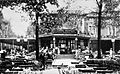
Venloer Straße 40: Stadtgarten (1907)

Venloer Straße 338: Ehrenfeld Town Hall (1902)

Venlo Gate: laying down (May 1911)

Venloer Straße 260: "Haus Mertens" (1853)

Venloer Straße 286: Church of St. Joseph

Venloer Straße 531: residential and commercial building (around 1890)


In the spring of 1845, the first residential buildings were built on Venloer Strasse. The dance hall “Rothes Haus” was a tourist destination for Cologne residents from April 1845 until around 1850. The property built by FJ Maus was initially called “Effertsgut”. The oldest secular, still preserved "Haus Mertens" at no. 260 dates from 1853 and remained in family ownership between 1866 and 1971. It was one of the so-called "three-window houses" which, according to the Prussian building regulations, were tax-exempt with a width of up to 20 feet (6.28 meters). The oldest building is the Bickendorfer Rochus Chapel (No. 645), probably built in 1666 by the Cologne canon Heinrich von Mering , the new building was completed on August 12, 1849 according to plans by the cathedral builder Ernst Friedrich Zwirner . The Church of St. John in front of the Latin Gate in No. 1228 was built by Vincenz Statz in 1851-1853 . The Fort VII as part of the Cologne fortress ring was south of the Venloerstraße and was 1841-1846 to a design by Heinrich Ferdinand Schuberth built. In the course of the construction of the railway line, it was closed around 1912. After 1889, the “Kölner Tattersaal” used as a riding arena was built on the site.
industrialization

Venloer Straße 241: Foundation building from 4711 (1874)

Venloer Straße 241: Administration and storage center 4711 (today: "Barthonia-Forum")
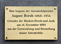
Venloer Straße 295: memorial plaque for August Horch

Venloer Straße 387–389: Helioswerke (before 1900)

Venloer Straße 387–389: Heliosturm

Venloer Straße 387–389: View from the Heliosturm to the industrial city of Ehrenfeld (around 1900)
Venloer Straße 387–389: View from the Heliosturm (August 2006)


The Bickendorf freight depot , which opened in 1863 near Venloer Strasse , led to a number of industrial settlements. In addition to the six existing brickworks, the first factory to be built was that of the wallpaper manufacturer Philipp Hoffmann, after he had acquired a plot of land on March 20, 1845 at No. 308 / corner of Philippstrasse. This was followed by the Rheinische Glashütten-Actien-Gesellschaft (April 1864; No. 356), the wagon factory Peter Herbrand (September 1866; No. 427) also manufactured horse-drawn trams (also for Berlin), Ferdinand Mülhens relocated part of his 4711 in March 1874 -Production from Glockengasse to Venloer Straße 241 / Vogelsanger Straße 66-100. Helios AG , founded on July 31, 1884, set up a 44-meter-high test lighthouse on its factory site in No. 387-389 in 1885 and sold lighthouses to Borkum ( Roter Sand ), Sylt ( Kampen ), Wangerooge and the Weser estuary. The entire sea signal technology of the Kiel Canal , consisting of 20 beacons, also came from here. The automobile manufacturer and Audi founder August Horch started developing in his company A. Horch & Cie. his first automobiles on Venloer Strasse 295 in a former horse stable. The first car ("Model 1") was built in July 1900 and was presented in January 1901 with a spectacular maiden voyage that was not entirely free of breakdowns. Due to a lack of money, the mechanical engineering company Bauer & Lange took a stake in Horch's company, which led to the move to Reichenbach in the Vogtland in March 1901 . The English gas company set up a gas factory near the Subbelrather Hof in 1860 and signed a gas supply contract with the Ehrenfeld community that ran until December 1894. In this, she undertook to set up 8 gas lamps on Venloer Strasse, which she had to maintain free of charge until December 1894. On August 28, 1897 , Cornelius Stüssgen opened his first grocery store, the “Kölner Konsumanstalt”, at Venloer Strasse 466 . The Mauser works were established in 1896 by the company's founder Alfons Mauser in Schramberg and moved to Venloer Strasse 155 in 1898; There they manufactured sheet steel goods such as steel furniture, steel packaging and tools, many of which received patents such as the famous "Mauser barrels". In 1922 the company moved to Brühl , where the packaging manufacturer Mauser GmbH still produces today.
In the meantime, the Engel pharmacy opened on Venloer Straße 325 in 1859. The upswing in Ehrenfeld led to the spin-off from Müngersdorf on January 1, 1867 and merger with Subbelrath, and on October 8, 1879 to the final departure from the mayor's association through the award of the Rhenish city regulations . In 1880 the representative, neo-Gothic style Ehrenfeld town hall, planned by Vincenz Statz, was completed in No. 338. It was demolished in 1956 because of war damage. In the city council meeting on May 4, 1882, the existing street name Venloer Straße was confirmed. A horse-drawn bus line from Ehrenfeld-Neumarkt-Bocklemünd began in 1887, and the horse-drawn tram line, which opened on October 31, 1891, connected Venloer Strasse with Heumarkt .
Modern times
Since September 14, 1902, the electric tram has been running from Heliosstrasse via Venloer Strasse to Cologne-Kalk , followed by the “Neumarktbahn” on the same day and the “Stadtgartenbahn” to Heumarkt on March 1, 1903. Operator Ernst Hardt & Co. obtained the cars from the nearby Herbrand works. Since May 1935 there was a central gypsy camp at No. 888 on the embankment of the Bickendorf freight station , to which the gypsies living in caravans were forcibly assigned.
The "small housing colony" settlement Bickendorf I-III was built according to the garden city concept between 1913 and 1938 by a team of architects led by Wilhelm Riphahn , the first project by GAG Immobilien . Of the three construction phases, the so-called "Rosenhof-Siedlung" Bickendorf II is located on Venloer Straße and connects to the south of the already existing "Siedlung Bickendorf I" and the "Gartensiedlung Bickendorf III". Houses 716–724 were built by 1940. Many of the buildings in Ehrenfeld and on Venloer Strasse fell victim to the bombing of May 30, 1942 during the Second World War . On March 6, 1945, American soldiers marched across the rubble landscape of Venloer Strasse.
There were a total of 12 cinemas on Venloer Strasse, including the Monopol Theater in No. 250 (1920–1929), Union-Lichtspiele Ehrenfeld No. 254 (1917–1929), Urania-Lichtspiele No. 265 (1913–1984), Kino für Jedermann No. 312 (1952), Helios Ehrenfeld No. 383 (1908–1982), Astoria Bickendorf No. 569 (1925–1959), Atelier in the UFA-Palast No. 658, Rochus Bickendorf No. 626 (1929–1941 ) or Die Crank Bickendorf No. 668 (1949–1957).
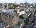
Herbert Eklöh opened the first American-style supermarket in Germany on September 26, 1957 in the Rheinlandhalle (No. 389) with a sales area of 2000 m². Between 1955 and 1961, a building complex was built by Peter Neufert for the building and agricultural machinery trade Gebrüder Finger in No. 1275 , which is still used today by Fasieco-Finger . In 1962, 4711 moved into the new administration building planned by the house architects Rudolf and Wilhelm Koep at no. 241–245 / corner of Vogelsanger Strasse. These 4 hectare factories were built in several construction stages from 1950, the hallmarks of which are the curtain walls in the company colors gold (gold anodized steel frame) and turquoise blue (glass plates). After 4711 moved here in 1991, the "Barthonia Forum" was created in 1994 with a rental area of 119,295 m² (named after investor Heinz Barth), which opened on November 5, 1996. The striking Westcenter (601–603), built in 1971 by Franz Kaiser and consisting of 4 buildings, consists of 407 apartments with 20,300 m² of living space on 25 floors and was acquired in July 2014 by European Property Investors Special Opportunities 3 for 27.5 million euros. In 1985 the district town hall opened (419–421), the subway line of the Cologne Stadtbahn under Venloer Strasse opened on May 30, 1992. On November 7, 2009, the foundation stone for the DITIB Central Mosque in Cologne was laid in No. 160 .
Buildings and landmarks

Venloer Straße: Cologne West train station

Venloer Straße 273: St. Mary's Assumption (July 2008)

Venloer Straße 378–389: Helios building

Venloer Straße 601–603: Rochuskapelle and Westcenter (March 2005)
Venloer Straße 732: "Siedlung Bickendorf II" (May 2010)

Venloer Straße 1152: Jewish cemetery (March 2007)

Venloer Straße 1203: Fettenhof (around 1912)


The residential and commercial buildings in the first section after Friesenplatz date back to the 19th century, for example No. 10 (1885), No. 11 (1884) or No. 28 (1894). The following city garden is the remainder of a larger park that later had to give way to the Cologne West train station and was laid out in 1833 by Johann Peter Weyer . The Stadtgarten restaurant at No. 40 dates from 1898, the construction of which was supervised by the city gardener Adolf Kowallek . The Cologne West train station (Hans-Böckler-Platz) opened for passenger traffic on May 25, 1894, the entrance facade of which is now from the time it was founded. On February 17, 1956, the city decided to rename the western side of the Venloer Wall in Hans-Böckler-Platz , the trade union building at Venloer Strasse 42 was given the address Hans-Böckler-Platz 1 on April 20, 1965. The houses No. 231 –235 date from 1886.
The market chapel of St. Mariä Himmelfahrt (“Maatkapell”) with its forecourt facing Venloer Straße (No. 273) commemorates the founder of Ehrenfeld, the brickworks owner Johann Wahlen, who had it built as a family chapel by his son-in-law Vincenz Statz and inaugurated in February 1863. The transeptless Catholic parish church of St. Joseph (1872/75) at No. 286, planned by the same architect, is designed in the neo-Gothic style and is the largest church in the district. The Rheinlandhalle (No. 389) was a converted assembly hall of the Helioswerke, which had functioned as an event hall with a cycling track since October 1927. Here Adolf Hitler had his first appearance in Cologne on August 18, 1930 in front of 10,000 spectators on the occasion of the upcoming Reichstag election. No. 535 is Cologne's oldest coffee roastery, "Schamong Coffee" from September 1949, at No. 951 a Roman fountain was found. This is followed by two manors, namely the Weyerhof / Palanterhof (No. 1178) from 1778 and the Arnoldshof (No. 1198). The Arnoldshof is named after the tenant Arnold Conzen, who lived here around 1650. The dark red brick building with the year 1741 in wall anchors is the oldest farm in the area, its manor house was classified as dilapidated in 1985 and sold in 1988. After the renovation of the 8,500 m² property, 15 courtyard houses and 18 country-style condominiums were built, which were ready for occupancy in November 1991. The Fettenhof in No. 1203 was first mentioned in 1170. “Fats” used to be understood to mean bars that fenced off courts or places of assembly. The manor building with stables was rebuilt around 1820. The owner of the property was the city of Cologne, which in 1976 left it to the “ Compagnons du Devoir ” as a long-term lease. Up to 70 French journeyman craftsmen lived here and renovated the property between 1977 and 1988 and completely refurbished it between 2009 and December 2011 so that it could be sold as condominiums. The journeymen had to give up the farm in 2004 due to insufficient staff. The first burial took place on October 1, 1917 in the 523,000 m² West Cemetery at No. 1132. The neighboring, 44,818 m² Jewish cemetery in No. 1152 was built in 1918, the entrance buildings are by Robert Stern, built until May 1930. With around 5000 grave sites, it is the largest Jewish cemetery in Cologne.
Location and importance
When Ehrenfeld was founded, Venloer Strasse was a favorable prerequisite for developing space as a trunk road that had been recently expanded. It is the most important shopping street in the Ehrenfeld district and at the same time an important transport link to Cologne city center. The street, which is partially equipped with a median , has the highest house numbers in Germany, within the city limits up to No. 1451, continuing in Pulheim to No. 1501. In Cologne, it leads through the districts of Neustadt-Nord , Ehrenfeld , Bickendorf , Bocklemünd / Mengenich and Vogelsang . Important road crossings in Cologne are Bismarckstrasse (with a connection to the Belgian Quarter ), Hans-Böckler-Platz, Innere Kanalstrasse , Piusstrasse / Franz-Geuer-Strasse, Sömmeringstrasse / Hansemannstrasse, Ehrenfeldgürtel, Leyendeckerstrasse, Äußere Kanalstrasse, Militärringstrasse and junction 102 to the federal motorway 1 . The Cologne Stadtbahn serves Venloer Straße with lines 3, 4 and 13 (sometimes also line 5). Below the Venloerstraße the light rail Cologne runs of lines 3 and 4 with the stops Metro Station Hans-Böckler-Platz / Bf West , Piusstraße , Körnerstraße , Metro Station Venloerstraße / belt , Metro Station Leyendeckerstraße , äußere kanalstraße and Akazienweg . Then it runs above ground on Venloer Straße.
The Venloer Straße is part of the federal highway 59 ( ![]() ) and runs from the border of the administrative district of Cologne via Rommerskirchen , Rheydt , Mönchengladbach and Viersen to the state border at Kaldenkirchen before Venlo . In Pulheim it still leads past Pulheimer See as Venloer Straße and forms the L 183 / K 24 at the Bonnstraße intersection , in Rommerskirchen it is called Grevenbroicher Straße, which is called Kölner Landstraße after the intersection with the K 26 and via the Autobahn junction Mönchengladbach via the federal motorway 61 continues (94.7 km).
) and runs from the border of the administrative district of Cologne via Rommerskirchen , Rheydt , Mönchengladbach and Viersen to the state border at Kaldenkirchen before Venlo . In Pulheim it still leads past Pulheimer See as Venloer Straße and forms the L 183 / K 24 at the Bonnstraße intersection , in Rommerskirchen it is called Grevenbroicher Straße, which is called Kölner Landstraße after the intersection with the K 26 and via the Autobahn junction Mönchengladbach via the federal motorway 61 continues (94.7 km).
media
The car workshop of Holger Parsch, one of the filming locations of the VOX series and YouTube channel “ Die Autodoctors ” , is at number 725 in a backyard .
Others
Web links
Individual evidence
- ^ Hiltrud Kier : Cologne: Kunstführer, 1980, p. 147
-
^ Hermann von Weinsberg: Book Weinsberg. Volume 2, 1553, Leipzig 1887, p. 24
where the virgin monastery used to be - ↑ the monastery was built in 1180 for regular canons and was named after the parish church "zu den Martyrern" (from Latin "ad martyres"; incorrect pronunciation resulted in "Mechtern")
- ^ Hiltrud Kier: Cologne: Kunstführer, 1980, p. 147
- ↑ Heinrich Rösger: Ehrenfeld, suburb of Cologne. 1868, p. 21 ff.
- ^ Joseph Klersch, Heribert A. Hilgers: From the Imperial City to the Big City: Cityscape and Economy in Cologne 1794-1860. 1925, p. 110
- ^ Gerhard Curdes, Markus Ulrich: The development of the Cologne urban area. 1997, p. 188
- ↑ Barbara Becker-Jákli: Fear God, honor the king. 1988, p. 143
- ^ Henriette Meynen: The residential buildings in the north-western suburb of Cologne with Ehrenfeld as the center. 1978, p. 40
- ^ Henriette Meynen: The residential buildings in the north-western suburb of Cologne with Ehrenfeld as the center. 1978, p. 40
- ↑ the estate, first mentioned in 1227, was located on the Ehrenfeldgürtel / Subbelrather Straße
- ↑ Here Wahlen donated the market band
- ^ Henriette Meynen: The residential buildings in the north-western suburb of Cologne with Ehrenfeld as the center. 1978, p. 41
- ^ Henriette Meynen: Research on German regional studies. Volumes 210-211, 1978, p. 280
- ↑ Heinrich Rösger: Ehrenfeld, suburb of Cologne. 1868, p. 22
- ↑ it is part of the Cologne – Aachen railway line built between 1838 and 1841
- ↑ Soap production took place here between 1874 and 1943 and 1946 to 1993
- ↑ Kölner Geschichtsverein: Yearbook. Volume 73, 2002, p. 60
- ↑ Heinrich Rösger: Ehrenfeld, suburb of Cologne. 1868, p. 26
- ↑ the name developed from Obelraedt, Sobbelroide and Zobelrode
- ↑ Fred Kaufmann, Dagmar Lutz, Gudrun Schmitz-Esters: Cologne street names: Neustadt and Deutz. 1996, p. 134
- ^ Nazi Documentation Center: Cologne under National Socialism. 2001, p. 163
- ^ Construction phase I: 1913-1919 Riphahn / Caspar Maria Grod with over 800 residential units and 578 single-family homes; II: 1923–1938 Riphahn / Grod with 1121 apartments as "Rosenhof-Siedlung"; III: 1919-1926
- ^ Peter Fuchs: Chronicle of the history of the city of Cologne. Volume 2, 1991, p. 295
- ↑ Rotary construction of the warehouse and dispatch building in 1950, extension and soap factory in 1958, administration building in 1962
- ↑ Fred Kaufmann, Dagmar Lutz, Gudrun Schmitz-Esters: Cologne street names: Neustadt and Deutz. 1996, p. 62
- ^ Hiltrud Kier, Ulrich Krings: Stadtspuren, Denkmäler in Köln. Volume 2, 1998, p. 225
- ^ Society for transnational cooperation: documents. Volume 62, 2006, p. 62
- ^ Gerhard Curdes, Markus Ulrich: The development of the Cologne urban area. 1997, p. 188
- ↑ Klaus Barber: 007 is at 17: Famous numbers and their stories. 2015, 1503
- ↑ Otto von Mülmann : Statistics of the administrative district of Düsseldorf. Volume 3, 1867, p. 646
Coordinates: 50 ° 56 ′ 52 ″ N , 6 ° 55 ′ 19.5 ″ E