Benton, Alabama
| Benton | |
|---|---|
|
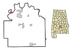
Location in Alabama
|
|
| Basic data | |
| Foundation : | 1832 |
| State : | United States |
| State : | Alabama |
| County : | Lowndes County |
| Coordinates : | 32 ° 18 ′ N , 86 ° 49 ′ W |
| Time zone : | Central ( UTC − 6 / −5 ) |
| Residents : | 49 (as of 2010) |
| Population density : | 61.3 inhabitants per km 2 |
| Area : | 0.9 km 2 (approx. 0 mi 2 ) of which 0.8 km 2 (approx. 0 mi 2 ) is land |
| Height : | 43 m |
| Postal code : | 36785 |
| Area code : | +1 334 |
| FIPS : | 01-05692 |
| GNIS ID : | 0113937 |
Benton is a city in Lowndes County in the US state of Alabama . According to the 2000 census, Benton had 47 inhabitants, according to an estimate from 2010 it was 49 inhabitants.
geography
Benton's geographic coordinates are 32 ° 18 ′ N , 86 ° 49 ′ W (32.306248, −86.817551). According to the United States Census Bureau , Benton has a total area of 0.9 km², of which 0.8 km² is land and 0.1 km² (= 8.82%) is water. The city is located in central Alabama in the southern United States and directly on the 512-kilometer-long Alabama River , which later merges into the Mobile River and finally flows into the Mobile Bay and the Gulf of Mexico .
Nearby locations include White Hall (6 km east), Tyler (7 km northwest), Sardis (16 km southwest), and Selma (20 km northwest). The next larger city with 205,000 inhabitants is the capital of Alabama, Montgomery, about 37 kilometers to the east .
history
The town's original name was Maull's Landing , as it was on land that James Maull had acquired. In 1832 he laid out today's city there. It received its new name when it was incorporated in reference to Thomas Hart Benton , a commanding officer from South Carolina . In the steamship era , Benton became a trading center on the Alabama River . In 1855 the urban area was greatly expanded after Edward Maull bought large pieces of land and ceded them to the city. In 1870 about 2627 people lived here.
When rail traffic replaced steamships as the most important means of transport, the importance of the city declined rapidly and its population declined, until today only a few dozen residents have remained in the city.
traffic
US Highway 80 and Alabama State Route 8 run through the south of the city on a shared route .
About 15 kilometers to the west is the airport of the city of Selma, Craig Field , 36 kilometers east also the Montgomery Regional Airport .
Demographics
According to the 2000 census , Benton had 47 inhabitants, divided into 18 households and 14 families. The population density was 58.5 inhabitants / km². 76.6% of the population were white and 24.4% were African American. children under the age of 18 lived in 38.9% of households. The average household income was $ 90,000 and 7.5% of the population lived below the poverty line .
By the 2010 census , the population rose slightly to 49.
Personalities
- Bill Traylor (1856–1949), self-taught draftsman and painter
Web links
- Statistical data on Benton (English)
- Benton in the Encyclopedia of Alabama (English)
