Berghöfe (Wittenberge)
|
Berghöfe
City of Wittenberge
Coordinates: 52 ° 58 ′ 41 ″ N , 11 ° 48 ′ 11 ″ E
|
|
|---|---|
| Height : | 20 m |
| Postal code : | 19322 |
| Area code : | 03877 |
|
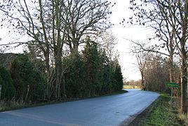
Village road north of the development
|
|
Berghöfe is a residential area in the Lütjenheide district of the city of Wittenberge in the Prignitz district in Brandenburg .
geography
The place is a good five hundred meters east-northeast from Lütjenheide and just under four kilometers east-southeast from Wittenberge. He is surrounded by the FFH area Elbdeichvorland, the bird sanctuary Lower Elbe Valley, the nature reserve Wittenberge-Rühstädter Labe region, the Biosphere Reserve Riverine Landscape Elbe and the conservation area Brandenburg Elbe Valley.
Immediately to the east of the locality is the Kreuzwasser, an about 3.6 hectare backwater , which is used today as fishing waters. To the north the Karthane flows past the place. Neighboring towns are Breese in the north, Klein Lüben in the east, Zwischenendeich and Schadebeuster in the south and Lütjenheide and Wallhöfe in the west.
literature
- Historical Gazetteer Brandenburg - Part 1 - Prignitz - A-M . Modifications made by Lieselott Enders . In: Klaus Neitmann (Ed.): Publications of the Brandenburgisches Landeshauptarchiv (State Archive Potsdam) - Volume 3 . Founded by Friedrich Beck . Publishing house Klaus-D. Becker, Potsdam 2012, ISBN 978-3-88372-032-6 , pp. 241,535 .
Web links
- Berghöfe in the historical directory of the association for computer genealogy
- Information about the city on wittenberge.de
Individual evidence
- ↑ a b City of Wittenberge - districts according to § 45 municipal constitution. In: service.brandenburg.de. Ministry of the Interior and Local Affairs of the State of Brandenburg, accessed on April 13, 2015 .
- ↑ a b Map service for protected areas. Federal Agency for Nature Conservation, accessed on April 13, 2015 .
- ↑ Water profile Kreuzwasser. In: anglermap.de. Gerhard Michling, accessed April 13, 2015 .

