Bierbach (Odenwald)
|
Bierbach
Coordinates: 49 ° 45 ′ 44 ″ N , 8 ° 51 ′ 28 ″ E
|
|
|---|---|
| Height : | 196 m above sea level NN |
| Postal code : | 64395 |
| Area code : | 06161 |

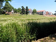
Fire water and fish pond next to the Bierbach
Bierbach is a hamlet that lies on both sides of the Bierbach . This body of water represents the boundary between Fränkisch-Crumbach and Wersau (municipality of Brensbach ) in Hesse . The settlement has no local character. It consists of a farm south of the stream and three farms on the north side. The existence of the hamlet is documented under the spelling Burbach since 1314 and as Burlebach in 1433.
Transport and infrastructure
Bierbach is accessible to traffic via a municipal road. This branches off from Kreisstraße 74 at the exit of Wersau to the south and ends in Bierbach. Bierbach has the same postcode and phone code as Brensbach.
Web links
Commons : Bierbach - Collection of images, videos and audio files
- Bierbach (Wersau district), Odenwaldkreis. Historical local dictionary for Hessen. In: Landesgeschichtliches Informationssystem Hessen (LAGIS).
- Bierbach (Fränkisch-Crumbach district), Odenwaldkreis. Historical local dictionary for Hessen. In: Landesgeschichtliches Informationssystem Hessen (LAGIS).
Individual evidence
- ↑ Karl E. Demandt: Regesten der Graf von Katzenelnbogen. No. 3617, April 14, 1433

