Bierberg (Kalefeld)
| Bierberg | ||
|---|---|---|
|
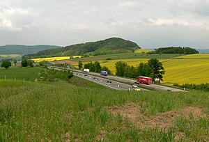
Beer mountain from the south with the Federal Highway 7 seen |
||
| height | 267.5 m above sea level NHN | |
| location | Lower Saxony , Germany | |
| Coordinates | 51 ° 46 '33 " N , 10 ° 2' 17" E | |
|
|
||
The Bierberg is a nearly 267.5 m high mountain near Kalefeld in the Northeim district .
location
It is located south of Kalefeld and Echte . It is also north of Imbshausen and east of Eboldshausen . The federal motorway 7 , where a motorway parking lot is named after him , runs past the mountain to the west , and the B 248 passes to the east, and the B 445 and the Aue (Leine) to the north .
history
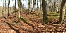
In the early Middle Ages there was probably the Bierburg on the top of the mountain , which is still visible today as an unevenness in the ground.
This is where the Northeim Landwehr ran. The Schnedekrug carter pub was built at the Landwehr passage .
In October 1545, in the run-up to the Schmalkaldic War, there was a clash of opposing troops with a strength of more than 10,000 men each, although Moritz (Saxony) was still trying to mediate. Landgrave Philip I (Hesse) , whose ally Ernst III. (Braunschweig-Grubenhagen) , had the better position from Bierberg and was able to arrest the Catholic Heinrich II (Braunschweig-Wolfenbüttel) when he came to his army camp for talks in good faith . Despite the mediation efforts of his ally Hilmar von Münchhausen , he was arrested with his son in Ziegenhain and was not released until 1547.
literature
- Georg Frebold: Geological Guide through the Hannoversche Bergland, Volume 1, 1925, p. 47
Web links
Individual evidence
- ↑ NiedersachsenViewer, scale 1: 1000 on the official map 1: 5000, no terrain point recognizable, accessed on March 13, 2013 ( memento of the original from January 20, 2016 in the Internet Archive ) Info: The archive link was inserted automatically and has not yet been checked. Please check the original and archive link according to the instructions and then remove this notice.
- ↑ Dietrich Denecke : Methodical investigations, in: Göttinger geographische Abhandlungen 54, 1969, pp. 150, 200
- ↑ Helmut Jäger, Erhard Kühlhorn: Historical and regional excursion map of Lower Saxony: sheet Osterode am Harz, 1970, p. 108
- ^ Erich Brandenburg: Moritz von Sachsen, 1898, p. 403
- ^ Friese: Allusions to the history of the city of Northeim, in: Vaterländisches Archiv des Historisches Verein für Niedersachsen, 1840, page 322
- ↑ Yearbook of the History Association for the Duchy of Braunschweig, 1903, p. 1ff


