Bierlichtbach
| Bierlichtbach | ||
|
|
||
| Data | ||
| location | Niederau and Priestewitz , District of Meissen , Saxony , Germany | |
| River system | Elbe | |
| Drain over | Hopfenbach → Röderneugraben → Große Röder → Schwarze Elster → Elbe → North Sea | |
| source | In Ockrilla , district of Niederau 51 ° 11 ′ 36 ″ N , 13 ° 30 ′ 12 ″ E |
|
| muzzle | Northwest of Lenz in den Hopfenbach Coordinates: 51 ° 15 '17 " N , 13 ° 32' 44" E 51 ° 15 '17 " N , 13 ° 32' 44" E
|
|
| Left tributaries | Bach from Stauda | |
| Right tributaries | Erlichtbach , Pferdebach | |
The Bierlichtbach is a flowing body of water in the municipalities of Niederau and Priestewitz in the Saxon district of Meißen .

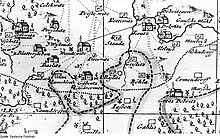
Lower course of the Bierlichtbach on a map of the Grossenhain office drawn by Adam Friedrich Zürner , 1711/1730
The 4.8 km long tributary of the Hopfenbach , a tributary of the Große Röder , has its source on the B 101 in Ockrilla , a district of Niederau. From there it flows in a north-easterly direction through Jessen and Böhla , then between the Priestewitz districts of Baßlitz and Geißlitz . It flows into the Hopfenbach northwest of Lenz .
In the winter of 2015/2016, a measure to improve flood protection was carried out in Böhla .
Footnotes
-
↑ Announcement: widening of the trench profile Bierlichtbach in 01561 Priestewitz. eVergabe.de, 2015, accessed on July 29, 2017 . Jörg Richter: sloppiness on the Bierlichtbach. In: Saxon newspaper . February 13, 2016. Retrieved July 29, 2017 .