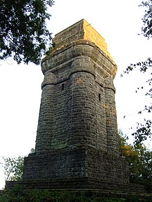
Bismarck Tower (Kassel)
| Bismarck Tower | |
|---|---|
| Tower type: | Observation tower |
| State : | Germany |
| State : | Hesse |
| Location : | kassel |
| Location : | on the Brasselsberg |
| Geo coordinates : | 51 ° 17 '24 " N , 9 ° 24' 26.5" E |
| Site altitude: | approx. 432 m above sea level NHN |
| Tower height: | 25.5 m |
| Viewing platform height: | 456.3 m above sea level NHN |
| Construction time : | 1903-1904 |
The Bismarck Tower in Kassel is a lookout tower built from 1903 to 1904 on the Brasselsberg in the Hohen Habichtswald in Northern Hesse ( Germany ) and with a height of 25.5 m it is the highest of 47 Bismarck towers based on the "Götterdämmerung" design.
Geographical location
The Bismarck Tower is located in the Habichtswald Nature Park about 70 m south-southeast of the summit of the Brasselsberg ( 434.2 m above sea level ), a mountain spur on the eastern flank of the Kassel part of the Hohe Habichtswald .
Bismarck Tower
Description and history
The foundation work for the Bismarck Tower took place in 1903. The actual construction work began on February 15, 1904. The supporting masonry of the tower was made from basalt stones, the facing from basalt tuff and the original steps were made from basalt, whereby the basalt and basalt tuff was mostly extracted in the Hohe Habichtswald . The drawn-in ceilings and the viewing platform were constructed as concrete ceilings with iron girders. The work ended in August 1904. The 25.5 m high tower was inaugurated on September 2, 1904 ( Sedan Day).
The square base of the tower is 8.66 m by 8.66 m. In addition to the 10 outer steps leading to the base of the tower, there were originally 86 steps inside the tower that led to the upper floor of the tower at a height of 15.48 m, from where 25 more steps lead to the viewing platform. Nowadays there are a total of 120 inner steps. The square viewing platform, which is 456.3 m above sea level. NHN is 4.92 m by 4.92 m inside diameter.
The tower had to be renovated several times, for example after lightning struck during a thunderstorm on May 28, 1962, and the balustrade on the north-west side was damaged. The tower reopened on April 15, 1967. Between August 1996 and October 10, 1997, renovation work was carried out on the tower crown and shaft. The 100th anniversary of the tower was celebrated on September 2nd, 2004. From mid-2008 to mid-October 2010, the building was closed due to severe damage to the staircase. Therefore, in 2010 the iron staircase filled with concrete was replaced by a stainless steel staircase.
Possibility of viewing
The tower's viewing platform offers a particularly good view of Kassel and the low mountain ranges surrounding the Kassel basin (see also here ). Among other things, these goals can be recognized from up there: in the north-north-east the Reinhardswald , in the north-east the Harz with the Brocken , in the east the Kaufunger Wald , the Hohe Meißner and the Söhre , in the south-east the Große Inselsberg in the Thuringian Forest and the Alheimer in the Stölzinger mountains , in the south-southeast, the in Baunatal standing Volkswagen plant in Kassel , in the south of Baunsberg and beyond the Knüllgebirge the southwest its Langeberge . Over the forest landscape of the Habichtswald you can look to the north-north-west located figure of Hercules , which can be seen especially in the cold season directly above the bare tree tops.
Individual evidence
- ↑ a b c d e f g h i j k l m n o p q r s t u Bismarckturm Kassel , on bismarcktuerme.de
- ↑ a b Topographic map Stadtatlas Kassel ( M. = 1: 10.000), publisher : Stadt Kassel, Vermessung und Geoinformation, 2009
- ↑ a b Article Bismarck Tower open again , on stadtteilkultur-brasselsberg.de (pdf; 955.8 kB)
Web links
- View from the Bismarck Tower (labeling of visual targets can be activated), on panorama-photo.net

