Blavet (Brittany)
| Blavet | ||
| Data | ||
| Water code | FR : J5-0210 | |
| location | France , Brittany region | |
| River system | Blavet | |
| source | in the parish of Bourbriac 48 ° 26 ′ 55 ″ N , 3 ° 14 ′ 39 ″ W |
|
| Source height | approx. 283 m | |
| muzzle |
Atlantic Ocean near Port-Louis Coordinates: 47 ° 44 ′ 17 " N , 3 ° 20 ′ 31" W 47 ° 44 ′ 17 " N , 3 ° 20 ′ 31" W |
|
| Mouth height | 0 m | |
| Height difference | approx. 283 m | |
| Bottom slope | approx. 1.9 ‰ | |
| length | 149 km | |
| Left tributaries | Sulon , Daoulas , Ével | |
| Right tributaries | Sarre , Scorff | |
| Small towns | Pontivy | |
| Navigable | from the mouth to Pontivy | |
|
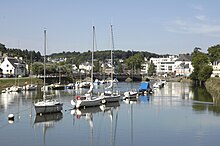
The Blavet at Pontivy |
||
The Blavet is a coastal river in Brittany , in north-west France .
geography
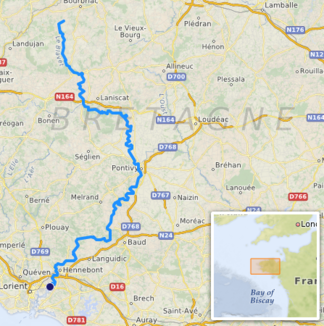
The source of the Blavet is located in the municipality of Bourbriac in the Côtes-d'Armor department . The river meets the Canal de Nantes à Brest near Gouarec , takes in the Daoulas and flows south into the Morbihan department . There it touches Pontivy , where the Canal de Nantes à Brest divides into two arms, one of which, the Canal du Blavet, forms the further course of the river to Hennebont . At the end of its course, the Blavet forms the Rade de Lorient Bay , which flows into the Scorff from the north , and flows into the Atlantic Ocean at Port-Louis after 149 kilometers . It feeds the lakes on its way
shipping
The river has been channeled through locks and is therefore suitable for shipping in its lower reaches. Today 28 locks are still in operation between Pontivy and the estuary. To the north of Pontivy, the Blavet is part of the Canal de Nantes à Brest , which can no longer be navigated in the direction of Brest . However, you can continue east on this canal, for example to Rohan or Redon . Below Hennebont , the river is influenced by the tides and is one of the sea waterways .


