
Boardwalk in Wittmoor

With Wittmoor bog trackway two are prehistoric trackways referred to 1898 (Bohlenweg I) and 1904 (boardwalk II) in Wittmoor in the north of Hamburg were discovered. The boardwalk dates from the 4th and 7th centuries AD and connected the eastern and western banks of the marshy moor, which was then difficult to access . Part of the older Bohlenweg II is shown in the permanent archaeological exhibition of the Hamburg Archaeological Museum in Hamburg-Harburg .
Location

Both plank paths are found in Wittmoor, which lies in the area of the Hamburg districts of Duvenstedt and Lemsahl-Mellingstedt , and extends across Schleswig-Holstein to the Norderstedt district of Glashütte . When degradation of peat parts were cut planks of a historic path in Wittmoor over again. In 1898 the schoolmaster and local researcher Ludwig Frahm followed the advice of the carpenter Hinrich Mohr from Poppenbüttel, who showed him the location of the Bohlenweg I, which he called Russendamm . In 1900 Frahm exposed a larger part of the plank path and published his excavation results in 1901 and 1913. In total, two plank paths have been found in Wittmoor so far, which were excellently preserved due to the storage in the moist soil .
Boardwalk I

The Bohlenweg I was discovered in 1898, partially exposed in 1900 and 1901 by Frahm together with Prof. Wilms and examined again in the first half of the 20th century by the archaeologists Hugo Prejawa and Kolumbe. The path ran in an east-south-east direction across the Wittmoor and was about 500 m long. During the Second World War , the western part of the moor in particular was increasingly peated for fuel production , with larger parts of the path being destroyed. This boardwalk was much simpler than the older boardwalk II. The route only consisted of neatly hewn oak boards 180 to 200 cm long and 20 to 30 cm wide, which were laid directly on the surface of the moor without joists. The boardwalk was embedded in the peat just 1 m below the surface of the site. In this part of the moor, too, peat was regularly extracted for fuel production, whereby the path was also gradually destroyed. The well-preserved wooden planks along the way were used as firewood by the peat cutters.
Location: 53 ° 42 ′ 10 ″ N , 10 ° 4 ′ 18 ″ E
Bohlenweg II

Bohlenweg II was founded in 1904 by the Hamburg geologist Dr. Wolff discovered. This also ran in an east-south-east direction, about 500 m south-south-west and almost parallel to the plank path I, through the Wittmoor. This had a length of about 600 m. This path, too, was gradually destroyed by regular shedding. In 1947, Kellermann carried out excavations in the middle part of the path and found an approximately 2 m long stretch of path that is now on display in the permanent exhibition of the Hamburg Archaeological Museum. The substructure of the path consisted of two split oak planks , which were laid parallel to each other on a sand or gravel fill on the formerly marshy terrain. Layers of split oak boards about 130 to 160 cm in length and 25 to 45 cm in width and a thickness of two to six cm across the direction of the path were laid on the planks. The sleepers were notched to prevent them from slipping on the planks. Every second threshold was cut at an angle at the ends. Birch sticks were hammered into the ground through the gaps to prevent the sleepers from slipping. A large part of the path excavated by Kellermann resembled a construction site, in some cases the wood of the path had been torn out and thrown together in one place. Next to it were newly prepared pieces of wood, which were intended for installation, as well as objects interpreted as tools, such as a lifting tree and clapper . Charred small pieces of wood suggest a fireplace.
In 1938, the Bohlenweg was initially dated to the 6th century BC by means of pollen analysis , whereas a radiocarbon dating of 1957 showed an age around the birth of Christ. The more recent dendrochronological dating of 1996 showed that the trees were felled around the year 330 AD. Location: 53 ° 42 ′ 0 ″ N , 10 ° 4 ′ 10 ″ E
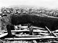
Excavation situation in the 1930s

Detail of Bohlenweg II in the 1930s
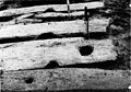
Mortise hole in a road plank in the 1930s


interpretation
With the discovery of the two plank paths, the doctrine at the time that such paths only occurred south of the Elbe could be corrected. The plank paths found show that in earlier times there was a lively exchange between the western and eastern banks of the moor and that the traffic routes were viewed as so important that a considerable logistical and material effort was made to build paths through the moor instead of closing it bypass or bypass. Archaeologically, however, no settlements belonging to the boardwalk have been proven.
literature
- Reinhard Schindler : The soil antiquities of the Free and Hanseatic City of Hamburg . Christians, Hamburg 1960, p. 119–121, map supplement 1 (different numbering of the plank paths).
- Erich Kolumbe, Max Beyle: The plank paths in Wittmoor (Holstein) and their position in the pollen diagram . In: Hansische Gilde (Hrsg.): From Hansisches Raum . Evert, Hamburg 1938.
- Ludwig Frahm : How we found the first boardwalk on Wittmoor . In: Yearbook of the Alster Association: 30 Years of the Alster Association . No. 18 . Christiansen, Hamburg-Wandsbek 1930, p. 26-29 .
- Hugo Prejawa: The boardwalk in Wittmoor (Holstein) . In: Communications from the Anthropological Association in Schleswig-Holstein . Lipsius & Tischer, Kiel 1911, p. 57-67, panel XI .
Web links
- Ferdinand Ziesche: Ludwig Frahm's thirst for research - discovery in Wittmoor . In: Alstertal magazine . November 2006, p. 118–119 ( alster-net.de [PDF; 257 kB ; accessed on July 6, 2012]).
- Nature - The Wittmoor at Vereinigung Duvenstedt e. V.
Individual evidence
- ↑ The names of the plank paths No. I for the northern, younger and No. II for the southern, older follow the names in the local archive of the Archaeological Museum Hamburg and the early publications (Schindler uses a different name for the paths).
- ↑ Subject area mobility, showcase No. 80.
- ↑ a b Rüdiger Articus, Jochen Brandt, Elke Först, Yvonne Krause, Michael Merkel, Kathrin Mertens, Rainer-Maria Weiss: Archaeological Museum Hamburg, Helms-Museum: A tour through the ages (= publications of the Archaeological Museum Hamburg Helms-Museum . No. 101 ). Hamburg 2009, ISBN 978-3-931429-20-1 , pp. 108 .
- ↑ a b Heinrich Friedrich Ludwig Frahm : How we found the first boardwalk on the Wittmoor . In: Yearbook of the Alster Association: 30 Years of the Alster Association . No. 18 . Christiansen, Hamburg-Wandsbek 1930, p. 26-29 .
- ^ A b Ferdinand Ziesche: Ludwig Frahm's urge to research - discovery in Wittmoor . In: Alstertal magazine . November 2006, p. 118–119 ( alster-net.de [PDF; 257 kB ; accessed on July 6, 2012]).
- ↑ a b c d e Reinhard Schindler: The soil antiquities of the Free and Hanseatic City of Hamburg . Hans Christians, Hamburg 1960, p. 119–121, map supplement 1 (different numbering of the plank paths).
- ↑ H. Preiawa: The Wittmoor bog trackway . In: Communications from the Anthropological Association in Schleswig-Holstein . No. 19 . Lipsius & Tische, 1901, ISSN 0179-9703 , p. 57-67 .
- ↑ R. Averdieck, Münnich: Palynological considerations on the history of settlements in the north of Hamburg with the aid of newer dating methods . In: Hammaburg . No. 5 , 1957, ISBN 978-3-931429-22-5 , ISSN 0173-0886 , pp. 9 .
- ^ Wulf Thieme: Old ways over the moor . In: H. Linde-Lebke (Ed.): From the former Tangstedter Heide to today's Norderstedter district Glashütte, 100 years 1896–1996 . S. 23-25 .
- ^ Wulf Thieme: 9. Prehistory and early history . In: Jürgen Ehlers (Ed.): Geological map of Hamburg 1:25 000 - Explanations for sheet no. 2326 Fuhlsbüttel . Geological State Office, Hamburg 2011, p. 82–106 , here pp. 100–102 ( hamburg.de [PDF; 12.1 MB ; accessed on July 6, 2012]).